Florence Topo Map Ohio
To zoom in, hover over the map of Florence
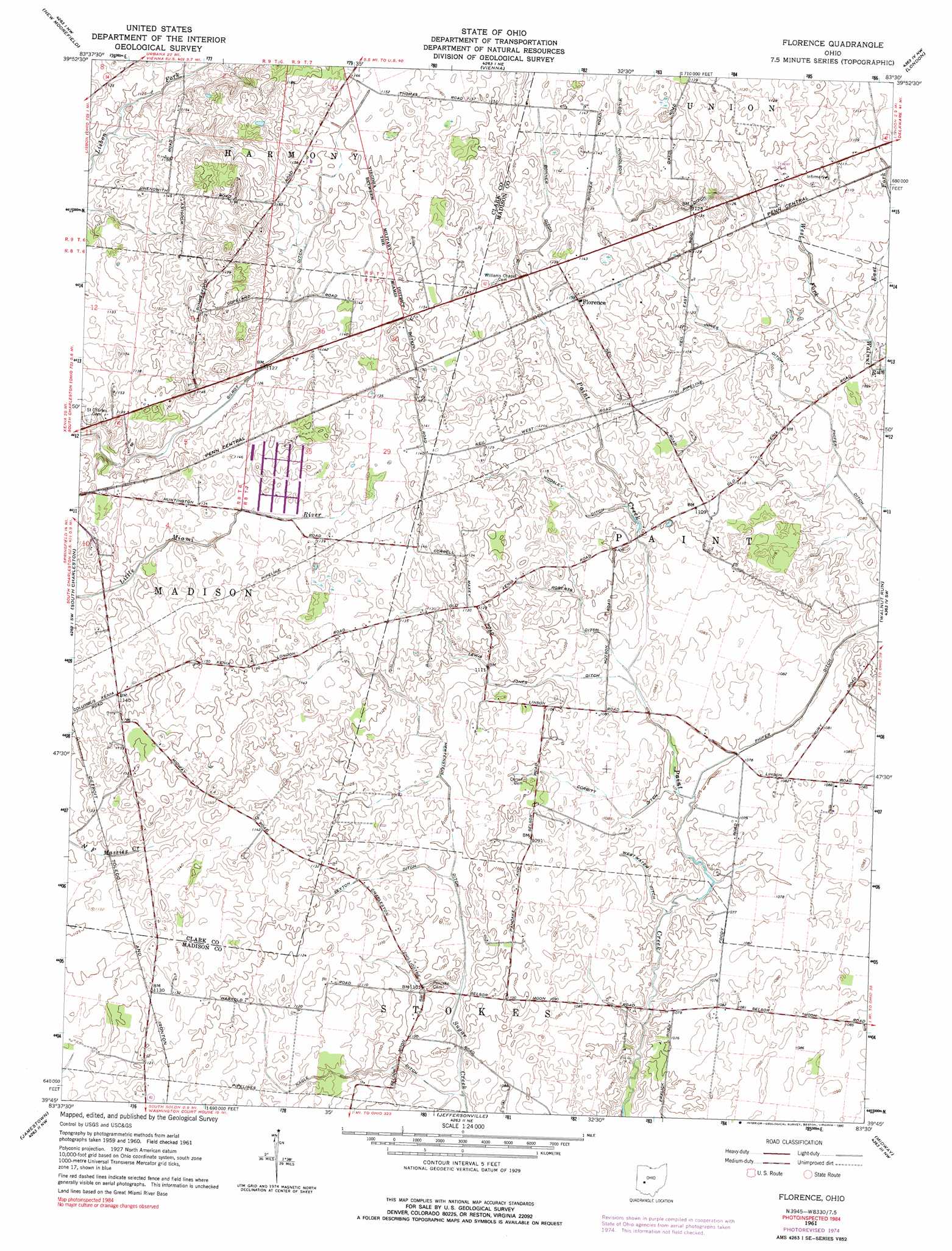
USGS Topo Quad 39083g5 - 1:24,000 scale
| Topo Map Name: | Florence |
| USGS Topo Quad ID: | 39083g5 |
| Print Size: | ca. 21 1/4" wide x 27" high |
| Southeast Coordinates: | 39.75° N latitude / 83.5° W longitude |
| Map Center Coordinates: | 39.8125° N latitude / 83.5625° W longitude |
| U.S. State: | OH |
| Filename: | o39083g5.jpg |
| Download Map JPG Image: | Florence topo map 1:24,000 scale |
| Map Type: | Topographic |
| Topo Series: | 7.5´ |
| Map Scale: | 1:24,000 |
| Source of Map Images: | United States Geological Survey (USGS) |
| Alternate Map Versions: |
Florence OH 1961, updated 1962 Download PDF Buy paper map Florence OH 1961, updated 1975 Download PDF Buy paper map Florence OH 1961, updated 1990 Download PDF Buy paper map Florence OH 2010 Download PDF Buy paper map Florence OH 2013 Download PDF Buy paper map Florence OH 2016 Download PDF Buy paper map |
1:24,000 Topo Quads surrounding Florence
Urbana West |
Urbana East |
Mechanicsburg |
Plumwood |
Plain City |
Springfield |
New Moorefield |
South Vienna |
London |
West Jefferson |
Clifton |
South Charleston |
Florence |
Walnut Run |
Big Plain |
Cedarville |
Jamestown |
Jeffersonville |
Midway |
Mount Sterling |
Port William |
Bowersville |
Milledgeville |
Washington Court House |
New Holland |
> Back to 39083e1 at 1:100,000 scale
> Back to 39082a1 at 1:250,000 scale
> Back to U.S. Topo Maps home
Florence topo map: Gazetteer
Florence: Airports
Gordin Airport elevation 346m 1135′Florence: Canals
Bonner Ditch elevation 345m 1131′Corbitt Ditch elevation 329m 1079′
Gilroy Ditch elevation 342m 1122′
Hertenstein Ditch elevation 334m 1095′
Jones Ditch elevation 338m 1108′
Nagle Ditch elevation 337m 1105′
Roberts Ditch elevation 333m 1092′
Sexton Ditch elevation 337m 1105′
Westwater Ditch elevation 327m 1072′
Wilson Nicholson Ditch elevation 345m 1131′
Woosley Ditch elevation 338m 1108′
Florence: Populated Places
Florence elevation 349m 1145′Florence: Streams
East Fork Walnut Run elevation 332m 1089′West Fork Walnut Run elevation 332m 1089′
Florence digital topo map on disk
Buy this Florence topo map showing relief, roads, GPS coordinates and other geographical features, as a high-resolution digital map file on DVD:
 map DVD")