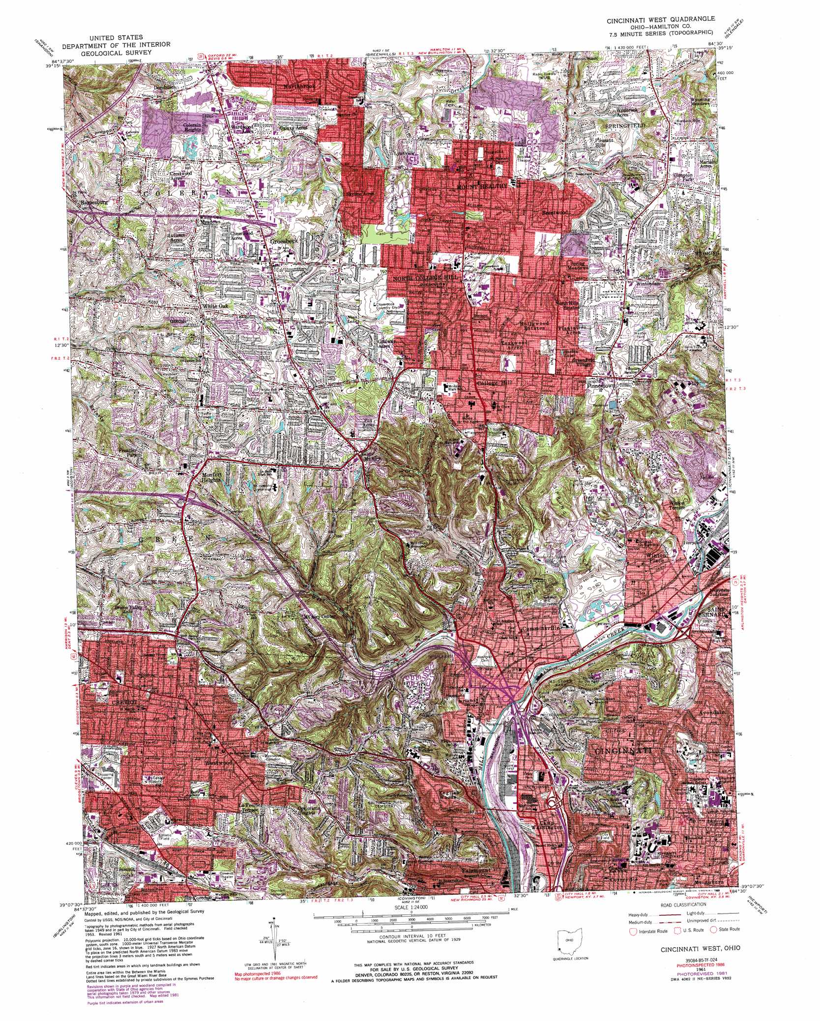
Cincinnati West Topo Map Ohio
To zoom in, hover over the map of Cincinnati West
USGS Topo Quad 39084b5 - 1:24,000 scale
| Topo Map Name: | Cincinnati West |
| USGS Topo Quad ID: | 39084b5 |
| Print Size: | ca. 21 1/4" wide x 27" high |
| Southeast Coordinates: | 39.125° N latitude / 84.5° W longitude |
| Map Center Coordinates: | 39.1875° N latitude / 84.5625° W longitude |
| U.S. State: | OH |
| Filename: | o39084b5.jpg |
| Download Map JPG Image: | Cincinnati West topo map 1:24,000 scale |
| Map Type: | Topographic |
| Topo Series: | 7.5´ |
| Map Scale: | 1:24,000 |
| Source of Map Images: | United States Geological Survey (USGS) |
| Alternate Map Versions: |
Cincinnati West OH 1953, updated 1955 Download PDF Buy paper map Cincinnati West OH 1961, updated 1963 Download PDF Buy paper map Cincinnati West OH 1961, updated 1971 Download PDF Buy paper map Cincinnati West OH 1961, updated 1976 Download PDF Buy paper map Cincinnati West OH 1961, updated 1982 Download PDF Buy paper map Cincinnati West OH 1961, updated 1989 Download PDF Buy paper map Cincinnati West OH 1961, updated 1989 Download PDF Buy paper map Cincinnati West OH 2010 Download PDF Buy paper map Cincinnati West OH 2013 Download PDF Buy paper map Cincinnati West OH 2016 Download PDF Buy paper map |
1:24,000 Topo Quads surrounding Cincinnati West
Reily |
Millville |
Hamilton |
Trenton |
Monroe |
Harrison |
Shandon |
Greenhills |
Glendale |
Mason |
Hooven |
Addyston |
Cincinnati West |
Cincinnati East |
Madeira |
Lawrenceburg |
Burlington |
Covington |
Newport |
Withamsville |
Rising Sun |
Union |
Independence |
Alexandria |
New Richmond |
> Back to 39084a1 at 1:100,000 scale
> Back to 39084a1 at 1:250,000 scale
> Back to U.S. Topo Maps home
Cincinnati West topo map: Gazetteer
Cincinnati West: Airports
Good Samaritan Hospital Heliport elevation 226m 741′Cincinnati West: Bridges
Hopple Street Viaduct elevation 143m 469′Cincinnati West: Crossings
Interchange 14 elevation 287m 941′Interchange 17 elevation 176m 577′
Interchange 18 elevation 155m 508′
Interchange 19 elevation 146m 479′
Interchange 4 elevation 167m 547′
Interchange 6 elevation 152m 498′
Interchange 9 elevation 161m 528′
Cincinnati West: Dams
Zillig Pond Dam elevation 264m 866′Cincinnati West: Forests
Mount Airy Forest elevation 241m 790′Cincinnati West: Islands
Strauch Island elevation 151m 495′Cincinnati West: Parks
Avenue Grounds (historical) elevation 149m 488′Blue Rock Oval elevation 152m 498′
Bosken Park elevation 263m 862′
Bracken Woods Park elevation 245m 803′
Brentwood Park elevation 234m 767′
Bron Bacevich Stadium elevation 163m 534′
Burnett Woods elevation 227m 744′
Campus Green elevation 232m 761′
Chester Park elevation 153m 501′
Cheviot Municipal Swimming Pool elevation 286m 938′
Cincinnati Zoological Gardens elevation 220m 721′
Classon Park elevation 260m 853′
College Hill Park elevation 269m 882′
Corryville Playground elevation 220m 721′
Corryville Triangle Park elevation 263m 862′
Edgewood Grove Park elevation 206m 675′
Emery Park elevation 170m 557′
Farbach-Werner Nature Preserve elevation 268m 879′
Felter Park elevation 233m 764′
Forest Avenue Wetland Park elevation 256m 839′
Fox Preserve elevation 244m 800′
Harvest Home Park elevation 286m 938′
Haubner Field elevation 277m 908′
Heritage Park elevation 243m 797′
Hille Playground elevation 143m 469′
Hoffner Historic District elevation 154m 505′
Jacob Hoffner Park elevation 152m 498′
La Boiteaux Woods elevation 211m 692′
Library Square elevation 241m 790′
Ludlow Monument elevation 150m 492′
Lytle Park elevation 151m 495′
McEvory Park elevation 251m 823′
McMicken Commons elevation 256m 839′
Mecklenburgs Garden elevation 245m 803′
Mount Airy Park elevation 264m 866′
Mount Storm Park elevation 224m 734′
Newberry Wildlife Sanctuary elevation 227m 744′
Nippert Stadium elevation 229m 751′
Oakamp Playground elevation 272m 892′
Saint Clair Heights Park elevation 242m 793′
Saint Peters Lick Run Historic District elevation 177m 580′
Salway Park elevation 149m 488′
Sigma Sigma Commons elevation 232m 761′
South Fairmount Playground elevation 148m 485′
Springfield Township Athletic Field elevation 249m 816′
Taft Field elevation 153m 501′
University Commons elevation 228m 748′
Valley Park elevation 155m 508′
Warder Park elevation 268m 879′
Wayne Playground elevation 155m 508′
Westwood Common elevation 270m 885′
Westwood Town Center Historic District elevation 275m 902′
Winton Commons elevation 180m 590′
Cincinnati West: Populated Places
Autumn Acres elevation 258m 846′Barnesburg elevation 245m 803′
Brentwood elevation 243m 797′
Camp Washington elevation 155m 508′
Chesswood Acres elevation 267m 875′
Cheviot elevation 277m 908′
Clifton elevation 209m 685′
Clifton Heights elevation 241m 790′
Colerain Heights elevation 268m 879′
College Hill elevation 272m 892′
Compton Park elevation 250m 820′
Corryville elevation 235m 770′
Crestwood Acres elevation 281m 921′
Cumminsville elevation 158m 518′
Cyclorama Heights elevation 268m 879′
Dornbusch elevation 266m 872′
English Woods elevation 239m 784′
Fairmount elevation 172m 564′
Finneytown elevation 271m 889′
Fox Acres elevation 273m 895′
Galaxy Acres elevation 250m 820′
Golfway Acres elevation 264m 866′
Greenfield Village elevation 260m 853′
Groesbeck elevation 264m 866′
Hollywood Estates elevation 252m 826′
Ivorydale Junction elevation 152m 498′
Knowltons Corner elevation 149m 488′
LaFeuille Terrace elevation 256m 839′
Losantville Triangle elevation 245m 803′
Lynnview elevation 243m 797′
Marlain Acres elevation 250m 820′
Monfort Heights elevation 273m 895′
Mount Airy elevation 286m 938′
Mount Airy Center elevation 253m 830′
Mount Healthy elevation 255m 836′
North College Hill elevation 251m 823′
North Hills Estates elevation 265m 869′
Northbrook elevation 253m 830′
Oakdale elevation 261m 856′
Pleasant Hills elevation 241m 790′
Rohs Hill elevation 253m 830′
Saint Jacobs elevation 270m 885′
Saint Peter elevation 158m 518′
Skyline Acres elevation 252m 826′
South Fairmount elevation 148m 485′
Spring Meadows elevation 250m 820′
Summit elevation 266m 872′
Teakwood Acres elevation 259m 849′
Wardwood Acres elevation 260m 853′
Werk Place elevation 280m 918′
Westwood elevation 277m 908′
White Oak elevation 279m 915′
White Oak Meadows elevation 278m 912′
Wildbrook Acres elevation 236m 774′
Winton Place elevation 170m 557′
Winton Terrace elevation 179m 587′
Wintondale elevation 259m 849′
Cincinnati West: Post Offices
Barnesburgh Post Office (historical) elevation 246m 807′Cheviot Post Office (historical) elevation 277m 908′
College Hill Post Office (historical) elevation 272m 892′
College Hill Station Cincinnati Post Office elevation 271m 889′
Cuminsville Post Office (historical) elevation 158m 518′
Cumminsville Station Cincinnati Post Office elevation 152m 498′
Groesbeck Branch Cincinnati Post Office elevation 265m 869′
Groesbeck Post Office (historical) elevation 262m 859′
Mount Airy Post Office (historical) elevation 286m 938′
Mount Healthy Branch Cincinnati Post Office elevation 260m 853′
Mount Healthy Post Office (historical) elevation 257m 843′
Plainville Post Office (historical) elevation 201m 659′
Westwood Post Office (historical) elevation 275m 902′
Westwood Station Cincinnati Post Office elevation 277m 908′
Winton Place Post Office (historical) elevation 166m 544′
Cincinnati West: Ranges
Clifton Hills elevation 213m 698′Cincinnati West: Reservoirs
Brickyard Pond elevation 255m 836′Dream Valley Lake elevation 261m 856′
Haskin Lake elevation 253m 830′
La Boiteaux Pond elevation 253m 830′
Nina Lake elevation 253m 830′
Zillig Pond elevation 264m 866′
Cincinnati West: Streams
Bruce Creek elevation 223m 731′Cabin Run elevation 221m 725′
Ross Run elevation 149m 488′
Shepherd Creek elevation 201m 659′
West Fork Mill Creek elevation 143m 469′
Cincinnati West: Woods
McFarlan Woods elevation 216m 708′Parker Woods elevation 172m 564′
Rawson Woods elevation 190m 623′
Cincinnati West digital topo map on disk
Buy this Cincinnati West topo map showing relief, roads, GPS coordinates and other geographical features, as a high-resolution digital map file on DVD:
Northern Illinois, Northern Indiana & Southwestern Michigan
Buy digital topo maps: Northern Illinois, Northern Indiana & Southwestern Michigan