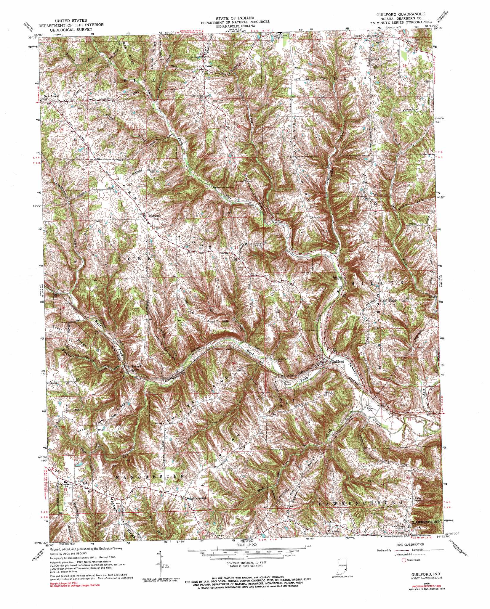
Guilford Topo Map Indiana
To zoom in, hover over the map of Guilford
USGS Topo Quad 39084b8 - 1:24,000 scale
| Topo Map Name: | Guilford |
| USGS Topo Quad ID: | 39084b8 |
| Print Size: | ca. 21 1/4" wide x 27" high |
| Southeast Coordinates: | 39.125° N latitude / 84.875° W longitude |
| Map Center Coordinates: | 39.1875° N latitude / 84.9375° W longitude |
| U.S. State: | IN |
| Filename: | o39084b8.jpg |
| Download Map JPG Image: | Guilford topo map 1:24,000 scale |
| Map Type: | Topographic |
| Topo Series: | 7.5´ |
| Map Scale: | 1:24,000 |
| Source of Map Images: | United States Geological Survey (USGS) |
| Alternate Map Versions: |
Guilford IN 1943 Download PDF Buy paper map Guilford IN 1953, updated 1955 Download PDF Buy paper map Guilford IN 1966, updated 1968 Download PDF Buy paper map Guilford IN 1966, updated 1990 Download PDF Buy paper map Guilford IN 2010 Download PDF Buy paper map Guilford IN 2013 Download PDF Buy paper map Guilford IN 2016 Download PDF Buy paper map |
1:24,000 Topo Quads surrounding Guilford
Metamora |
Brookville |
Whitcomb |
Reily |
Millville |
Batesville |
Spades |
Cedar Grove |
Harrison |
Shandon |
Pierceville |
Sunman |
Guilford |
Hooven |
Addyston |
Milan |
Dillsboro |
Aurora |
Lawrenceburg |
Burlington |
Cross Plains |
Bear Branch |
Aberdeen |
Rising Sun |
Union |
> Back to 39084a1 at 1:100,000 scale
> Back to 39084a1 at 1:250,000 scale
> Back to U.S. Topo Maps home
Guilford topo map: Gazetteer
Guilford: Airports
Helms-Jacobs Airport elevation 283m 928′Guilford: Dams
Kimberly Lake Dam elevation 271m 889′Guilford: Populated Places
Bonnell elevation 193m 633′Dover elevation 286m 938′
Guilford elevation 152m 498′
Kyle elevation 276m 905′
Logan elevation 281m 921′
Wrights Corner elevation 276m 905′
Yorkville elevation 284m 931′
Guilford: Ridges
Bockhorst Ridge elevation 245m 803′Collier Ridge elevation 263m 862′
Devils Backbone elevation 233m 764′
Ester Ridge elevation 271m 889′
Mount Pleasant Ridge elevation 244m 800′
Sawdon Ridge elevation 267m 875′
Sutton Ridge elevation 262m 859′
Turkey Point Ridge elevation 263m 862′
York Ridge elevation 284m 931′
Guilford: Streams
Brushy Fork elevation 161m 528′East Fork Tanners Creek elevation 146m 479′
Ennis Creek elevation 211m 692′
Flys Run elevation 179m 587′
Fox Run elevation 164m 538′
Kline Creek elevation 201m 659′
Leatherwood Creek elevation 209m 685′
Mud Lick Creek elevation 143m 469′
Norton Run elevation 171m 561′
Slab Camp Creek elevation 174m 570′
Soapstone Creek elevation 180m 590′
Turkey Fork elevation 210m 688′
Turkey Run elevation 225m 738′
West Fork Tanners Creek elevation 146m 479′
Ziegler Creek elevation 186m 610′
Guilford digital topo map on disk
Buy this Guilford topo map showing relief, roads, GPS coordinates and other geographical features, as a high-resolution digital map file on DVD:
Northern Illinois, Northern Indiana & Southwestern Michigan
Buy digital topo maps: Northern Illinois, Northern Indiana & Southwestern Michigan