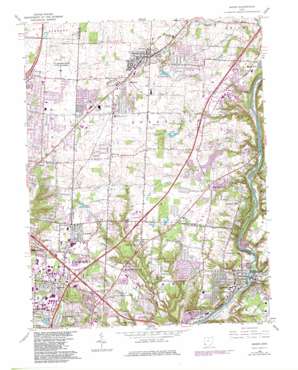
Mason Topo Map Ohio
To zoom in, hover over the map of Mason
USGS Topo Quad 39084c3 - 1:24,000 scale
| Topo Map Name: | Mason |
| USGS Topo Quad ID: | 39084c3 |
| Print Size: | ca. 21 1/4" wide x 27" high |
| Southeast Coordinates: | 39.25° N latitude / 84.25° W longitude |
| Map Center Coordinates: | 39.3125° N latitude / 84.3125° W longitude |
| U.S. State: | OH |
| Filename: | o39084c3.jpg |
| Download Map JPG Image: | Mason topo map 1:24,000 scale |
| Map Type: | Topographic |
| Topo Series: | 7.5´ |
| Map Scale: | 1:24,000 |
| Source of Map Images: | United States Geological Survey (USGS) |
| Alternate Map Versions: |
Mason OH 1955, updated 1956 Download PDF Buy paper map Mason OH 1965, updated 1968 Download PDF Buy paper map Mason OH 1965, updated 1976 Download PDF Buy paper map Mason OH 1965, updated 1982 Download PDF Buy paper map Mason OH 1965, updated 1982 Download PDF Buy paper map Mason OH 2010 Download PDF Buy paper map Mason OH 2013 Download PDF Buy paper map Mason OH 2016 Download PDF Buy paper map |
1:24,000 Topo Quads surrounding Mason
> Back to 39084a1 at 1:100,000 scale
> Back to 39084a1 at 1:250,000 scale
> Back to U.S. Topo Maps home
Mason topo map: Gazetteer
Mason: Airports
Armrel-Byrnes Heliport elevation 262m 859′United Heliport elevation 264m 866′
Youngs Field elevation 232m 761′
Mason: Crossings
Interchange 19 elevation 259m 849′Interchange 22 elevation 265m 869′
Interchange 24 elevation 223m 731′
Interchange 47 elevation 254m 833′
Interchange 50 elevation 241m 790′
Mason: Dams
Al-Char Lake Dam 9242-002 elevation 262m 859′Knechtly Pond Dam elevation 256m 839′
Landen Farm Dam elevation 241m 790′
Pine Hill Lake Dam elevation 247m 810′
Mason: Lakes
Al-Char Lakes elevation 252m 826′Cactus Lake elevation 228m 748′
Carter Lake elevation 262m 859′
Kenridge Lake elevation 246m 807′
Lake Chetac elevation 263m 862′
Mason: Parks
Blue Ash Sports Center elevation 262m 859′Bodley Park elevation 179m 587′
Ciutan Park elevation 236m 774′
Coach Bud Acus Field elevation 259m 849′
Corwin M Nixon Pine Hill Lakes Park elevation 250m 820′
Dulle Park elevation 232m 761′
East Loveland Nature Preserve elevation 177m 580′
Hidden Creek Park elevation 221m 725′
Johnson Nature Preserve elevation 248m 813′
Kings Island Amusement Park elevation 229m 751′
Kings Stadium elevation 225m 738′
Kiwanis Park elevation 179m 587′
Landen-Deerfield Park elevation 237m 777′
Lever Park elevation 230m 754′
McCoy Park elevation 222m 728′
McGinnis Park (historical) elevation 265m 869′
Meadows Park elevation 250m 820′
Oakwood Park elevation 253m 830′
Phillips Park elevation 210m 688′
Pisgah Youth Park elevation 290m 951′
Quinn Park elevation 262m 859′
Seven Gables Park elevation 246m 807′
Stonebridge Park elevation 250m 820′
Symmes Township Park elevation 232m 761′
Voice of America Park elevation 274m 898′
Weller Park elevation 237m 777′
Mason: Populated Places
Brecon elevation 265m 869′Brenner Woods elevation 271m 889′
Brookside Estates elevation 282m 925′
Butterworth (historical) elevation 182m 597′
Clearview elevation 274m 898′
Country Acres elevation 274m 898′
Emery Acres elevation 264m 866′
Foster elevation 182m 597′
Hazelwood elevation 258m 846′
Highpoint elevation 265m 869′
Kenridge elevation 250m 820′
Landen elevation 248m 813′
Loveland elevation 181m 593′
Loveland Park elevation 222m 728′
Mason elevation 247m 810′
Mason Mobile Home Park elevation 264m 866′
Miltomson elevation 281m 921′
Orchard Acres elevation 288m 944′
Pisgah elevation 296m 971′
Shawnee Mobile Home Court elevation 250m 820′
Sixteen Mile Stand elevation 245m 803′
Snidercrest elevation 268m 879′
Socialville elevation 285m 935′
Stonewall Estates elevation 278m 912′
Sunburst Hills elevation 280m 918′
Sycamore elevation 252m 826′
The Woods elevation 278m 912′
Twenty Mile Stand elevation 253m 830′
Twightwee elevation 176m 577′
Wildwood Acres elevation 278m 912′
Mason: Post Offices
Brecon Post Office (historical) elevation 265m 869′Hazlewood Post Office (historical) elevation 257m 843′
Loveland Post Office elevation 181m 593′
Pisgah Post Office (historical) elevation 298m 977′
Pisgah Post Office (historical) elevation 294m 964′
Sixteen Mile Stand Post Office (historical) elevation 246m 807′
Mason: Reservoirs
Al-Char Lake 9242-002 elevation 262m 859′Knechtly Pond elevation 256m 839′
Landen Farm Lake elevation 241m 790′
Pine Hill Lake elevation 247m 810′
Mason: Streams
Bares Run elevation 174m 570′Bear Run elevation 181m 593′
Davis Run elevation 246m 807′
Ertel Run elevation 174m 570′
Hoff Run elevation 179m 587′
O'Bannon Creek elevation 173m 567′
Pine Run elevation 228m 748′
Salt Run elevation 177m 580′
Simpson Creek elevation 184m 603′
Union Run elevation 180m 590′
Mason digital topo map on disk
Buy this Mason topo map showing relief, roads, GPS coordinates and other geographical features, as a high-resolution digital map file on DVD:
Northern Illinois, Northern Indiana & Southwestern Michigan
Buy digital topo maps: Northern Illinois, Northern Indiana & Southwestern Michigan


