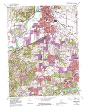
Greenhills Topo Map Ohio
To zoom in, hover over the map of Greenhills
USGS Topo Quad 39084c5 - 1:24,000 scale
| Topo Map Name: | Greenhills |
| USGS Topo Quad ID: | 39084c5 |
| Print Size: | ca. 21 1/4" wide x 27" high |
| Southeast Coordinates: | 39.25° N latitude / 84.5° W longitude |
| Map Center Coordinates: | 39.3125° N latitude / 84.5625° W longitude |
| U.S. State: | OH |
| Filename: | o39084c5.jpg |
| Download Map JPG Image: | Greenhills topo map 1:24,000 scale |
| Map Type: | Topographic |
| Topo Series: | 7.5´ |
| Map Scale: | 1:24,000 |
| Source of Map Images: | United States Geological Survey (USGS) |
| Alternate Map Versions: |
Greenhills OH 1955, updated 1957 Download PDF Buy paper map Greenhills OH 1955, updated 1957 Download PDF Buy paper map Greenhills OH 1965, updated 1968 Download PDF Buy paper map Greenhills OH 1965, updated 1975 Download PDF Buy paper map Greenhills OH 1965, updated 1982 Download PDF Buy paper map Greenhills OH 1965, updated 1982 Download PDF Buy paper map Greenhills OH 2010 Download PDF Buy paper map Greenhills OH 2013 Download PDF Buy paper map Greenhills OH 2016 Download PDF Buy paper map |
1:24,000 Topo Quads surrounding Greenhills
> Back to 39084a1 at 1:100,000 scale
> Back to 39084a1 at 1:250,000 scale
> Back to U.S. Topo Maps home
Greenhills topo map: Gazetteer
Greenhills: Airports
Hamilton County Sheriffs Patrol Heliport elevation 263m 862′Hamilton-Fairfield Airport elevation 189m 620′
Greenhills: Bridges
Jediah Hill Covered Bridge elevation 210m 688′Greenhills: Crossings
Interchange 33 elevation 267m 875′Interchange 36 elevation 256m 839′
Interchange 39 elevation 253m 830′
Greenhills: Dams
Tanglewood Lake Dam elevation 183m 600′Greenhills: Flats
Harper Meadows elevation 212m 695′Greenhills: Lakes
Lake Gloria elevation 260m 853′Greenhills: Parks
Benninghofen Playground elevation 182m 597′Central Park elevation 265m 869′
Dravo Park elevation 171m 561′
Fairfield Optimist Park elevation 171m 561′
Forest Lake Lane Fields elevation 171m 561′
Forestview Park elevation 262m 859′
Gilbert Park elevation 254m 833′
Gilmore Ponds Preserve Metropark elevation 183m 600′
Good Neighbors Park elevation 182m 597′
Greenhills Historic District elevation 244m 800′
Griesmer Playground elevation 178m 583′
Harbin Park elevation 262m 859′
Joyce Park elevation 169m 554′
Kemper Meadow Park elevation 261m 856′
Lakewood Park elevation 204m 669′
Lindenwald Park elevation 183m 600′
Lions Park elevation 181m 593′
Marsh Park elevation 171m 561′
Northbrook Civic Association Playfield elevation 259m 849′
Oakwood Park elevation 204m 669′
Pleasant Run Recreation Center elevation 226m 741′
Point Pleasant Soccer Fields elevation 191m 626′
Powerhouse Playground elevation 180m 590′
Richardson Forest Preserve elevation 218m 715′
Riverside Natural Area elevation 171m 561′
Schuster Park elevation 183m 600′
Water Works Park elevation 174m 570′
Winton Hills Park elevation 213m 698′
Winton Woods elevation 252m 826′
Greenhills: Populated Places
Athlone (historical) elevation 185m 606′Augusta Hills elevation 205m 672′
Bevis elevation 268m 879′
Brandy Wine elevation 174m 570′
Dixiedale elevation 184m 603′
Dry Ridge elevation 281m 921′
Dunlap elevation 261m 856′
Fairfield elevation 180m 590′
Fairplay elevation 172m 564′
Forest Park elevation 255m 836′
Furmandale elevation 192m 629′
Greenhills elevation 245m 803′
Griesmer Addition elevation 183m 600′
Indian Springs elevation 185m 606′
Ixworth (historical) elevation 186m 610′
Jones (historical) elevation 198m 649′
Lindenwald elevation 182m 597′
Mount Healthy Heights elevation 258m 846′
New Burlington elevation 250m 820′
Northgate elevation 269m 882′
Pleasant Run elevation 228m 748′
Pleasant Run Farm elevation 233m 764′
Schenck elevation 186m 610′
Skyview Acres Mobile Home Park elevation 195m 639′
Stockton elevation 212m 695′
Symmes Corner elevation 177m 580′
Town And Country Mobile Home Park elevation 184m 603′
Greenhills: Post Offices
Bevis Post Office (historical) elevation 268m 879′Dry Ridge Post Office (historical) elevation 278m 912′
Dunlap Post Office (historical) elevation 257m 843′
Fairfield Post Office elevation 178m 583′
New Burlington Post Office (historical) elevation 250m 820′
Pleasant Run Post Office elevation 228m 748′
Stockton Post Office (historical) elevation 214m 702′
Symmes Corners Post Office (historical) elevation 177m 580′
Greenhills: Reservoirs
Tanglewood Lake elevation 183m 600′Greenhills: Streams
Banklick Creek elevation 164m 538′Pleasant Run elevation 167m 547′
Greenhills digital topo map on disk
Buy this Greenhills topo map showing relief, roads, GPS coordinates and other geographical features, as a high-resolution digital map file on DVD:
Northern Illinois, Northern Indiana & Southwestern Michigan
Buy digital topo maps: Northern Illinois, Northern Indiana & Southwestern Michigan


