Lebanon Topo Map Ohio
To zoom in, hover over the map of Lebanon
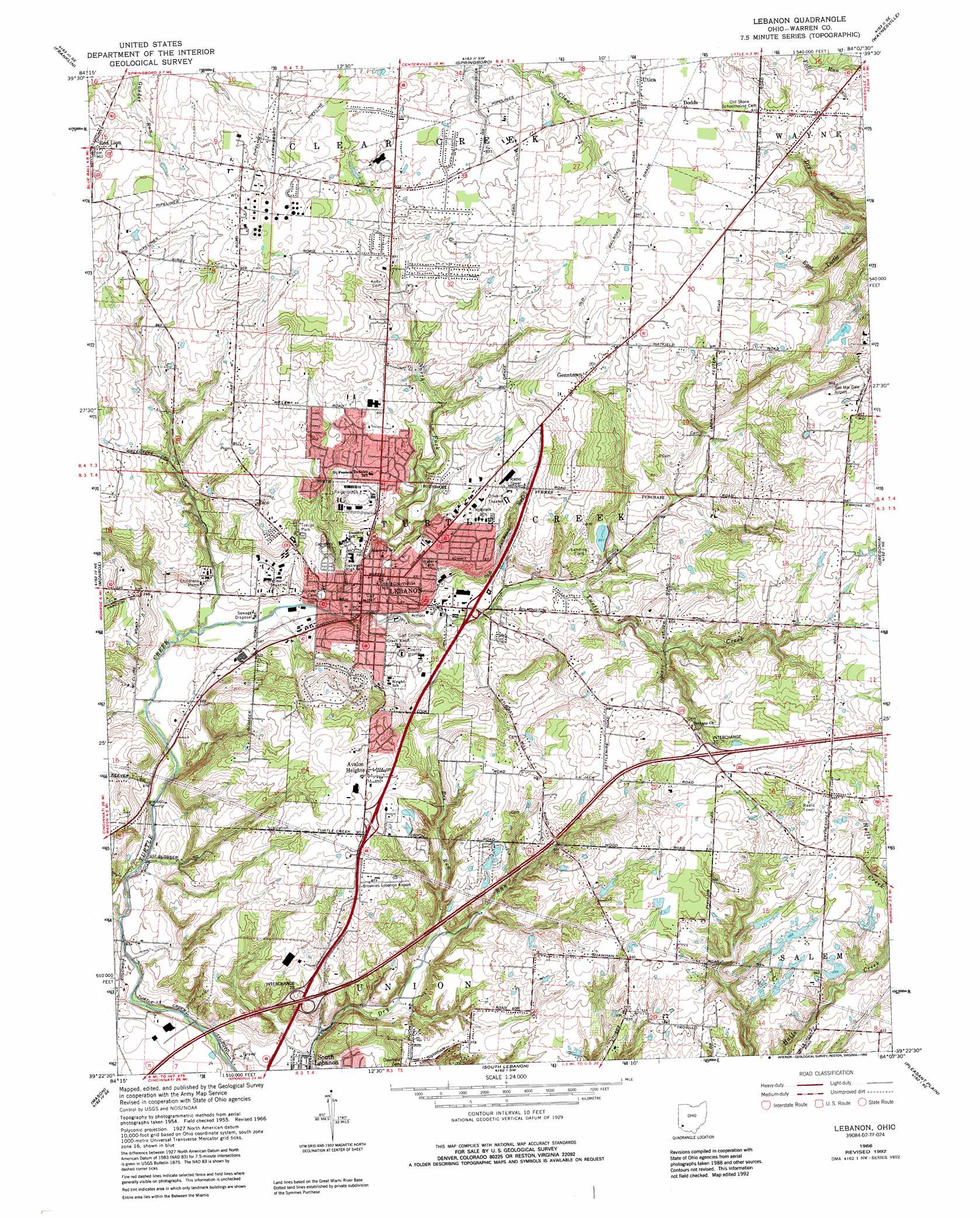
USGS Topo Quad 39084d2 - 1:24,000 scale
| Topo Map Name: | Lebanon |
| USGS Topo Quad ID: | 39084d2 |
| Print Size: | ca. 21 1/4" wide x 27" high |
| Southeast Coordinates: | 39.375° N latitude / 84.125° W longitude |
| Map Center Coordinates: | 39.4375° N latitude / 84.1875° W longitude |
| U.S. State: | OH |
| Filename: | o39084d2.jpg |
| Download Map JPG Image: | Lebanon topo map 1:24,000 scale |
| Map Type: | Topographic |
| Topo Series: | 7.5´ |
| Map Scale: | 1:24,000 |
| Source of Map Images: | United States Geological Survey (USGS) |
| Alternate Map Versions: |
Lebanon OH 1955, updated 1956 Download PDF Buy paper map Lebanon OH 1966, updated 1968 Download PDF Buy paper map Lebanon OH 1966, updated 1975 Download PDF Buy paper map Lebanon OH 1966, updated 1984 Download PDF Buy paper map Lebanon OH 1966, updated 1992 Download PDF Buy paper map Lebanon OH 2010 Download PDF Buy paper map Lebanon OH 2013 Download PDF Buy paper map Lebanon OH 2016 Download PDF Buy paper map |
1:24,000 Topo Quads surrounding Lebanon
Farmersville |
Miamisburg |
Dayton South |
Bellbrook |
Xenia |
Middletown |
Franklin |
Springboro |
Waynesville |
New Burlington |
Trenton |
Monroe |
Lebanon |
Oregonia |
Clarksville |
Glendale |
Mason |
South Lebanon |
Pleasant Plain |
Blanchester |
Cincinnati East |
Madeira |
Goshen |
Newtonsville |
Fayetteville |
> Back to 39084a1 at 1:100,000 scale
> Back to 39084a1 at 1:250,000 scale
> Back to U.S. Topo Maps home
Lebanon topo map: Gazetteer
Lebanon: Airports
Brownies Lebanon Airport elevation 264m 866′Maplewood Orchard Airport elevation 266m 872′
San Mar Gale Airport elevation 293m 961′
Lebanon: Crossings
Interchange 28 elevation 219m 718′Interchange 32 elevation 279m 915′
Lebanon: Dams
Boehmler Pond Dam elevation 246m 807′Fred Lake Dam elevation 228m 748′
Lilley Lake 9341-006 Dam elevation 267m 875′
Lilley Lake Dam elevation 257m 843′
Spear Pond Dam elevation 240m 787′
Stolle Lake Dam Number Two elevation 245m 803′
Lebanon: Parks
Colonial Park elevation 237m 777′East End Historic District elevation 237m 777′
Floraville Historic District elevation 227m 744′
Harmon Park elevation 218m 715′
Lebanon Commerical Historic District elevation 223m 731′
North Broadway Historic District elevation 224m 734′
Runyan Field elevation 215m 705′
Lebanon: Populated Places
Avalon Heights elevation 257m 843′Dodds elevation 296m 971′
Genntown elevation 286m 938′
Lebanon elevation 234m 767′
Lelan (historical) elevation 274m 898′
Merrittstown elevation 291m 954′
Red Lion elevation 293m 961′
Ridge (historical) elevation 265m 869′
Utica elevation 293m 961′
Lebanon: Post Offices
Lebanon Post Office elevation 219m 718′Lebanon: Reservoirs
Boehmler Pond elevation 246m 807′Fred Lake elevation 228m 748′
Lilley Lake elevation 257m 843′
Lilley Lake 9341-006 elevation 267m 875′
Spear Pond elevation 240m 787′
Stolle Lake elevation 245m 803′
Lebanon: Streams
Baker Creek elevation 275m 902′Bee Run elevation 207m 679′
French Run elevation 219m 718′
Howards Run elevation 201m 659′
Hutchinsons Run elevation 253m 830′
Irons Run elevation 244m 800′
Jamisons Run elevation 243m 797′
Little Muddy Creek elevation 195m 639′
Mooneys Run elevation 231m 757′
Mulfords Run elevation 203m 666′
Reeders Run elevation 204m 669′
Thompson Run elevation 238m 780′
Lebanon digital topo map on disk
Buy this Lebanon topo map showing relief, roads, GPS coordinates and other geographical features, as a high-resolution digital map file on DVD:
Northern Illinois, Northern Indiana & Southwestern Michigan
Buy digital topo maps: Northern Illinois, Northern Indiana & Southwestern Michigan