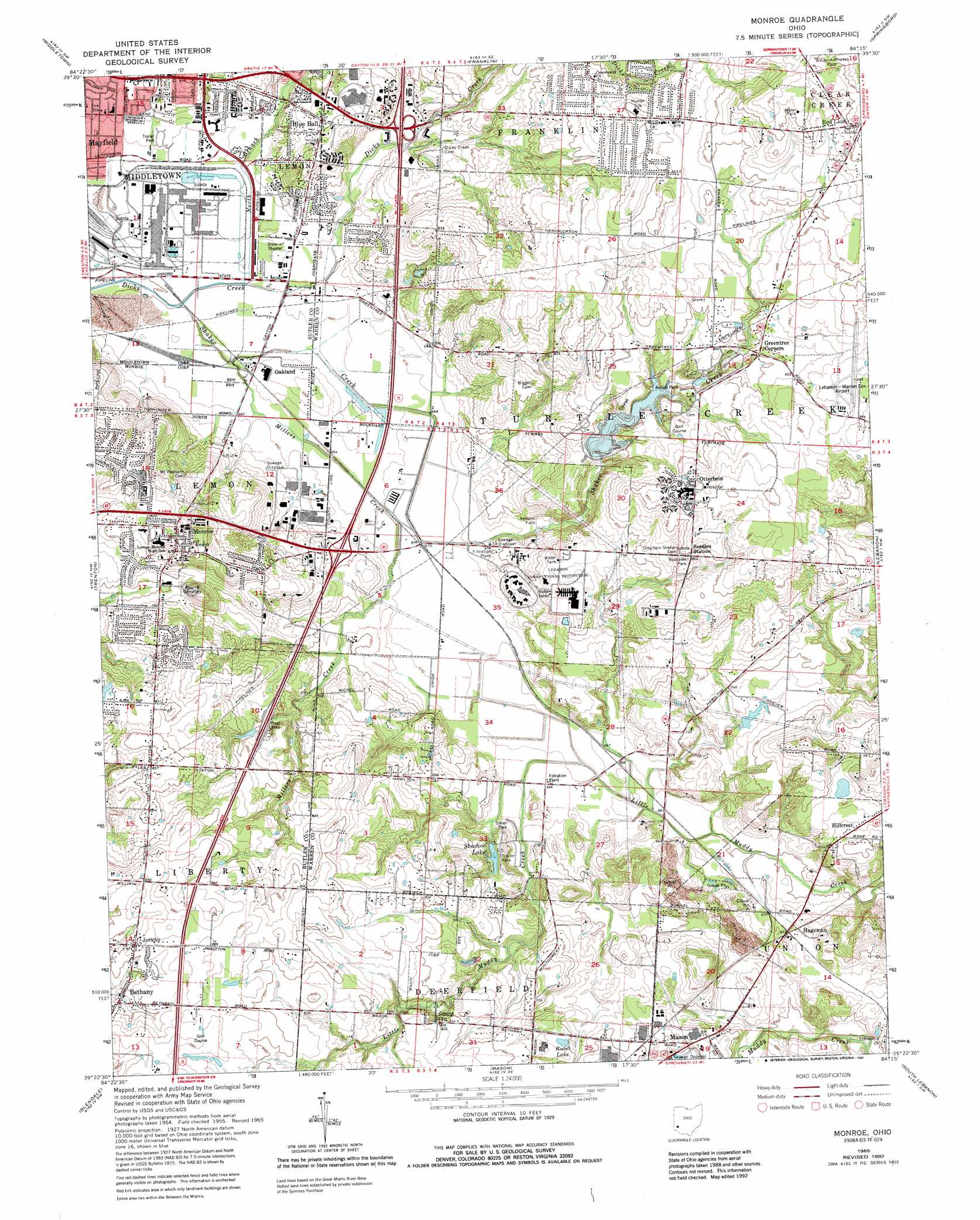
Monroe Topo Map Ohio
To zoom in, hover over the map of Monroe
USGS Topo Quad 39084d3 - 1:24,000 scale
| Topo Map Name: | Monroe |
| USGS Topo Quad ID: | 39084d3 |
| Print Size: | ca. 21 1/4" wide x 27" high |
| Southeast Coordinates: | 39.375° N latitude / 84.25° W longitude |
| Map Center Coordinates: | 39.4375° N latitude / 84.3125° W longitude |
| U.S. State: | OH |
| Filename: | o39084d3.jpg |
| Download Map JPG Image: | Monroe topo map 1:24,000 scale |
| Map Type: | Topographic |
| Topo Series: | 7.5´ |
| Map Scale: | 1:24,000 |
| Source of Map Images: | United States Geological Survey (USGS) |
| Alternate Map Versions: |
Monroe OH 1955, updated 1956 Download PDF Buy paper map Monroe OH 1965, updated 1967 Download PDF Buy paper map Monroe OH 1965, updated 1975 Download PDF Buy paper map Monroe OH 1965, updated 1984 Download PDF Buy paper map Monroe OH 1965, updated 1988 Download PDF Buy paper map Monroe OH 1965, updated 1992 Download PDF Buy paper map Monroe OH 2010 Download PDF Buy paper map Monroe OH 2013 Download PDF Buy paper map Monroe OH 2016 Download PDF Buy paper map |
1:24,000 Topo Quads surrounding Monroe
West Alexandria |
Farmersville |
Miamisburg |
Dayton South |
Bellbrook |
West Elkton |
Middletown |
Franklin |
Springboro |
Waynesville |
Hamilton |
Trenton |
Monroe |
Lebanon |
Oregonia |
Greenhills |
Glendale |
Mason |
South Lebanon |
Pleasant Plain |
Cincinnati West |
Cincinnati East |
Madeira |
Goshen |
Newtonsville |
> Back to 39084a1 at 1:100,000 scale
> Back to 39084a1 at 1:250,000 scale
> Back to U.S. Topo Maps home
Monroe topo map: Gazetteer
Monroe: Airports
District Number 8 Heliport elevation 256m 839′Lebanon-Warren County Airport elevation 270m 885′
Monroe: Crossings
Interchange 29 elevation 209m 685′Interchange 32 elevation 213m 698′
Monroe: Dams
Shadow Lake Dam elevation 237m 777′Shaker Creek Dam elevation 221m 725′
Shroder Lake Dam elevation 220m 721′
Monroe: Parks
Armco Park elevation 236m 774′Lefferson Softball Complex elevation 203m 666′
Monroe Park elevation 232m 761′
Monroe: Populated Places
Bethany elevation 256m 839′Blue Ball elevation 227m 744′
Brittany Heights elevation 237m 777′
Evergreen Farm Estates elevation 264m 866′
Greentree Corners elevation 259m 849′
Hageman elevation 204m 669′
Hillcrest elevation 223m 731′
Hunter elevation 270m 885′
Jericho elevation 265m 869′
Lemon elevation 233m 764′
Mayfield elevation 207m 679′
Monroe elevation 254m 833′
Oakland elevation 201m 659′
Otterbein elevation 270m 885′
Shadow Lake Village elevation 208m 682′
Stokes (historical) elevation 227m 744′
Taylor Village elevation 261m 856′
Monroe: Post Offices
Bethany Post Office (historical) elevation 256m 839′Bethany Post Office (historical) elevation 255m 836′
Blueball Post Office (historical) elevation 228m 748′
Lemon Post Office (historical) elevation 235m 770′
Monroe Post Office elevation 252m 826′
Monroe: Reservoirs
Armco Park Lake elevation 221m 725′Monroe Lake elevation 251m 823′
Rubel Lake elevation 229m 751′
Shadow Lake elevation 237m 777′
Shroder Lake elevation 220m 721′
Monroe: Streams
Ausbergers Creek elevation 200m 656′Clarks Run elevation 199m 652′
Eberharts Run elevation 210m 688′
Fanni Tellis Creek elevation 201m 659′
Harmon Run elevation 201m 659′
Hendricksons Run elevation 210m 688′
Hoovers Run elevation 217m 711′
Hudsons Run elevation 219m 718′
Keever Creek elevation 198m 649′
Millers Creek elevation 198m 649′
Nobles Fork elevation 268m 879′
North Branch Dicks Creek elevation 198m 649′
Shaker Creek elevation 198m 649′
Station Creek elevation 200m 656′
Swamp Run elevation 201m 659′
Monroe digital topo map on disk
Buy this Monroe topo map showing relief, roads, GPS coordinates and other geographical features, as a high-resolution digital map file on DVD:
Northern Illinois, Northern Indiana & Southwestern Michigan
Buy digital topo maps: Northern Illinois, Northern Indiana & Southwestern Michigan