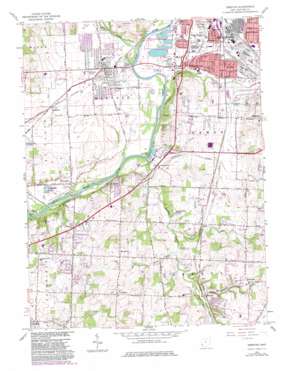
Trenton Topo Map Ohio
To zoom in, hover over the map of Trenton
USGS Topo Quad 39084d4 - 1:24,000 scale
| Topo Map Name: | Trenton |
| USGS Topo Quad ID: | 39084d4 |
| Print Size: | ca. 21 1/4" wide x 27" high |
| Southeast Coordinates: | 39.375° N latitude / 84.375° W longitude |
| Map Center Coordinates: | 39.4375° N latitude / 84.4375° W longitude |
| U.S. State: | OH |
| Filename: | o39084d4.jpg |
| Download Map JPG Image: | Trenton topo map 1:24,000 scale |
| Map Type: | Topographic |
| Topo Series: | 7.5´ |
| Map Scale: | 1:24,000 |
| Source of Map Images: | United States Geological Survey (USGS) |
| Alternate Map Versions: |
Trenton OH 1955, updated 1956 Download PDF Buy paper map Trenton OH 1966, updated 1968 Download PDF Buy paper map Trenton OH 1966, updated 1976 Download PDF Buy paper map Trenton OH 1966, updated 1983 Download PDF Buy paper map Trenton OH 1966, updated 1988 Download PDF Buy paper map Trenton OH 1966, updated 1988 Download PDF Buy paper map Trenton OH 2010 Download PDF Buy paper map Trenton OH 2013 Download PDF Buy paper map Trenton OH 2016 Download PDF Buy paper map |
1:24,000 Topo Quads surrounding Trenton
> Back to 39084a1 at 1:100,000 scale
> Back to 39084a1 at 1:250,000 scale
> Back to U.S. Topo Maps home
Trenton topo map: Gazetteer
Trenton: Crossings
Balls Ferry (historical) elevation 188m 616′Trenton: Forests
Rentschler Forest Preserve elevation 201m 659′Trenton: Lakes
Lesourdsville Lake elevation 187m 613′Trenton: Parks
Americana Amusement Park (historical) elevation 186m 610′Chrisholm Historic Farmstead Metropark elevation 199m 652′
Damon Park elevation 194m 636′
Douglas Park elevation 195m 639′
Dudley Woods Metropark elevation 202m 662′
Excello Locks Metropark elevation 189m 620′
Kumler Field elevation 202m 662′
Michigan Park elevation 200m 656′
Whitney Park elevation 198m 649′
Yankee Park elevation 203m 666′
Trenton: Populated Places
Arbor Crest elevation 232m 761′Bon Veue elevation 196m 643′
Brofield Estates elevation 242m 793′
Brookview elevation 225m 738′
Busenbark elevation 195m 639′
Country Club Highlands elevation 231m 757′
Country View Estates elevation 237m 777′
Dutchland Woods elevation 238m 780′
Excello elevation 191m 626′
Green Acres elevation 206m 675′
Greenlawn elevation 227m 744′
Greystone elevation 213m 698′
Hughes elevation 216m 708′
Hunting Creek Estates elevation 248m 813′
Huntsville elevation 254m 833′
Kyles elevation 216m 708′
Le Sourdsville elevation 196m 643′
Liberty Trails elevation 250m 820′
Linn-Crest Acres elevation 253m 830′
Maustown elevation 247m 810′
North Excello elevation 193m 633′
Oneida elevation 200m 656′
Princeton elevation 258m 846′
Rockdale elevation 210m 688′
Snow Hill elevation 256m 839′
South Excello elevation 211m 692′
South Middletown elevation 194m 636′
Trenton elevation 198m 649′
Woodsdale elevation 188m 616′
Woodsdale Park elevation 186m 610′
Trenton: Post Offices
Excello Post Office (historical) elevation 191m 626′Hughes Post Office (historical) elevation 219m 718′
Le Sourdsville Post Office (historical) elevation 195m 639′
Trenton Post Office elevation 198m 649′
Woodsdale Post Office (historical) elevation 189m 620′
Trenton: Reservoirs
Clearwater Lakes elevation 183m 600′Lake Brenda elevation 207m 679′
Twin Hill Lake elevation 213m 698′
Trenton: Streams
Coldwater Creek elevation 192m 629′Dicks Creek elevation 192m 629′
Elk Creek elevation 188m 616′
Gregory Creek elevation 186m 610′
Hunts Creek elevation 209m 685′
Panther Run elevation 197m 646′
Stony Run elevation 201m 659′
Trenton digital topo map on disk
Buy this Trenton topo map showing relief, roads, GPS coordinates and other geographical features, as a high-resolution digital map file on DVD:
Northern Illinois, Northern Indiana & Southwestern Michigan
Buy digital topo maps: Northern Illinois, Northern Indiana & Southwestern Michigan


