West Elkton Topo Map Ohio
To zoom in, hover over the map of West Elkton
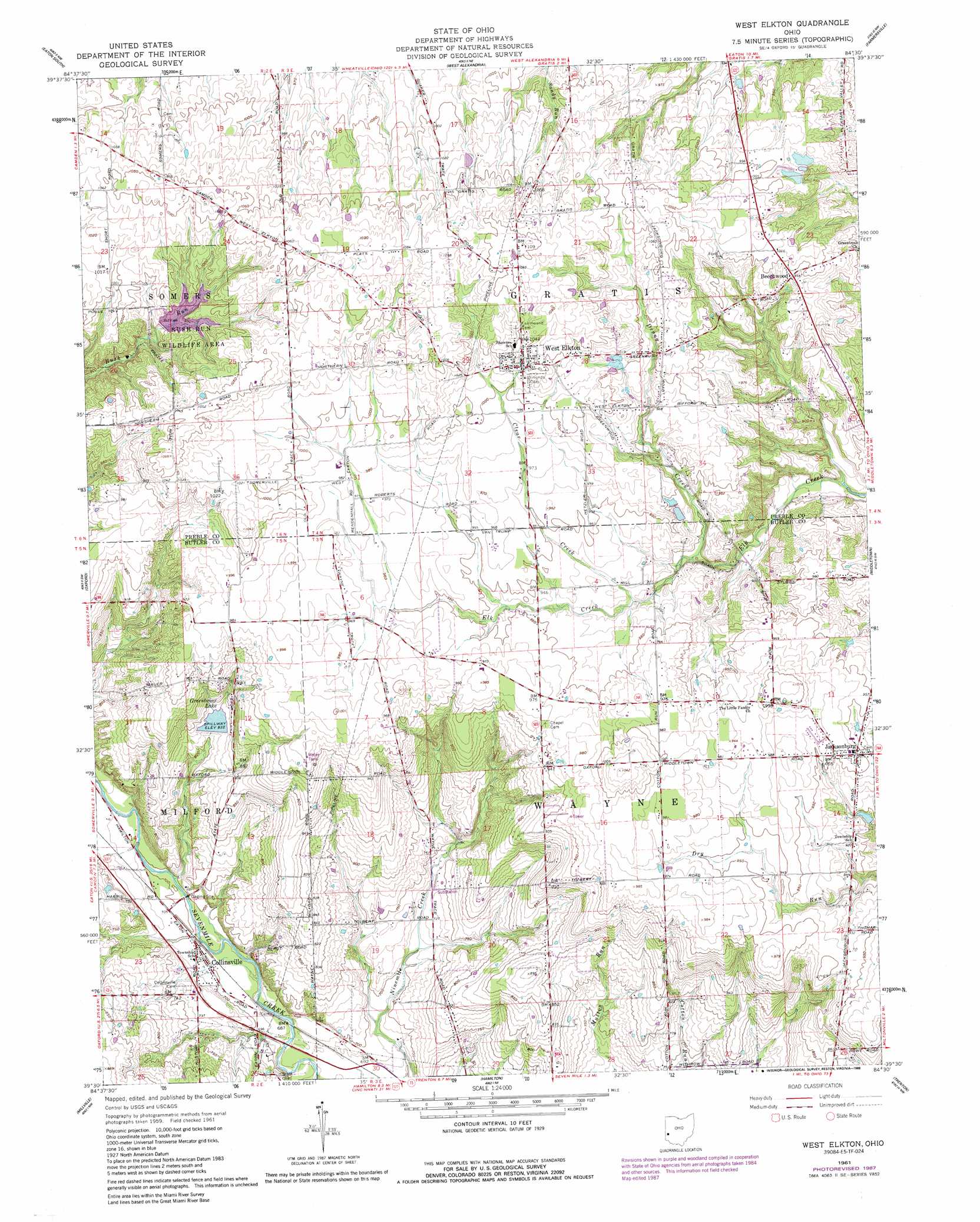
USGS Topo Quad 39084e5 - 1:24,000 scale
| Topo Map Name: | West Elkton |
| USGS Topo Quad ID: | 39084e5 |
| Print Size: | ca. 21 1/4" wide x 27" high |
| Southeast Coordinates: | 39.5° N latitude / 84.5° W longitude |
| Map Center Coordinates: | 39.5625° N latitude / 84.5625° W longitude |
| U.S. State: | OH |
| Filename: | o39084e5.jpg |
| Download Map JPG Image: | West Elkton topo map 1:24,000 scale |
| Map Type: | Topographic |
| Topo Series: | 7.5´ |
| Map Scale: | 1:24,000 |
| Source of Map Images: | United States Geological Survey (USGS) |
| Alternate Map Versions: |
West Elkton OH 1961, updated 1962 Download PDF Buy paper map West Elkton OH 1961, updated 1988 Download PDF Buy paper map West Elkton OH 2010 Download PDF Buy paper map West Elkton OH 2013 Download PDF Buy paper map West Elkton OH 2016 Download PDF Buy paper map |
1:24,000 Topo Quads surrounding West Elkton
New Paris |
Eaton North |
Lewisburg |
Brookville |
Trotwood |
Fairhaven |
Eaton South |
West Alexandria |
Farmersville |
Miamisburg |
College Corner |
Oxford |
West Elkton |
Middletown |
Franklin |
Reily |
Millville |
Hamilton |
Trenton |
Monroe |
Harrison |
Shandon |
Greenhills |
Glendale |
Mason |
> Back to 39084e1 at 1:100,000 scale
> Back to 39084a1 at 1:250,000 scale
> Back to U.S. Topo Maps home
West Elkton topo map: Gazetteer
West Elkton: Dams
Bear Pond Dam elevation 274m 898′Doughman Lake Dam elevation 228m 748′
Greenbriar Lake Dam elevation 247m 810′
Paradise Lakes-North Lake Dam elevation 289m 948′
Paradise Lakes-South Lake Dam elevation 289m 948′
Rush Run Lake Dam elevation 281m 921′
West Elkton: Parks
Rush Run Wildlife Area elevation 304m 997′West Elkton: Populated Places
Beechwood elevation 303m 994′Collinsville elevation 215m 705′
Jacksonburg elevation 293m 961′
West Elkton elevation 314m 1030′
West Elkton: Post Offices
Collinsville Post Office elevation 215m 705′West Elkton Post Office elevation 316m 1036′
West Elkton: Reservoirs
Bear Pond elevation 274m 898′Doughman Lake elevation 228m 748′
Greenbriar Lake elevation 247m 810′
Paradise Lakes-North Lake elevation 289m 948′
Paradise Lakes-South Lake elevation 289m 948′
Rush Run Lake elevation 281m 921′
West Elkton: Streams
Clear Creek elevation 279m 915′Denny Creek elevation 271m 889′
West Elkton digital topo map on disk
Buy this West Elkton topo map showing relief, roads, GPS coordinates and other geographical features, as a high-resolution digital map file on DVD:
Northern Illinois, Northern Indiana & Southwestern Michigan
Buy digital topo maps: Northern Illinois, Northern Indiana & Southwestern Michigan