College Corner Topo Map Ohio
To zoom in, hover over the map of College Corner
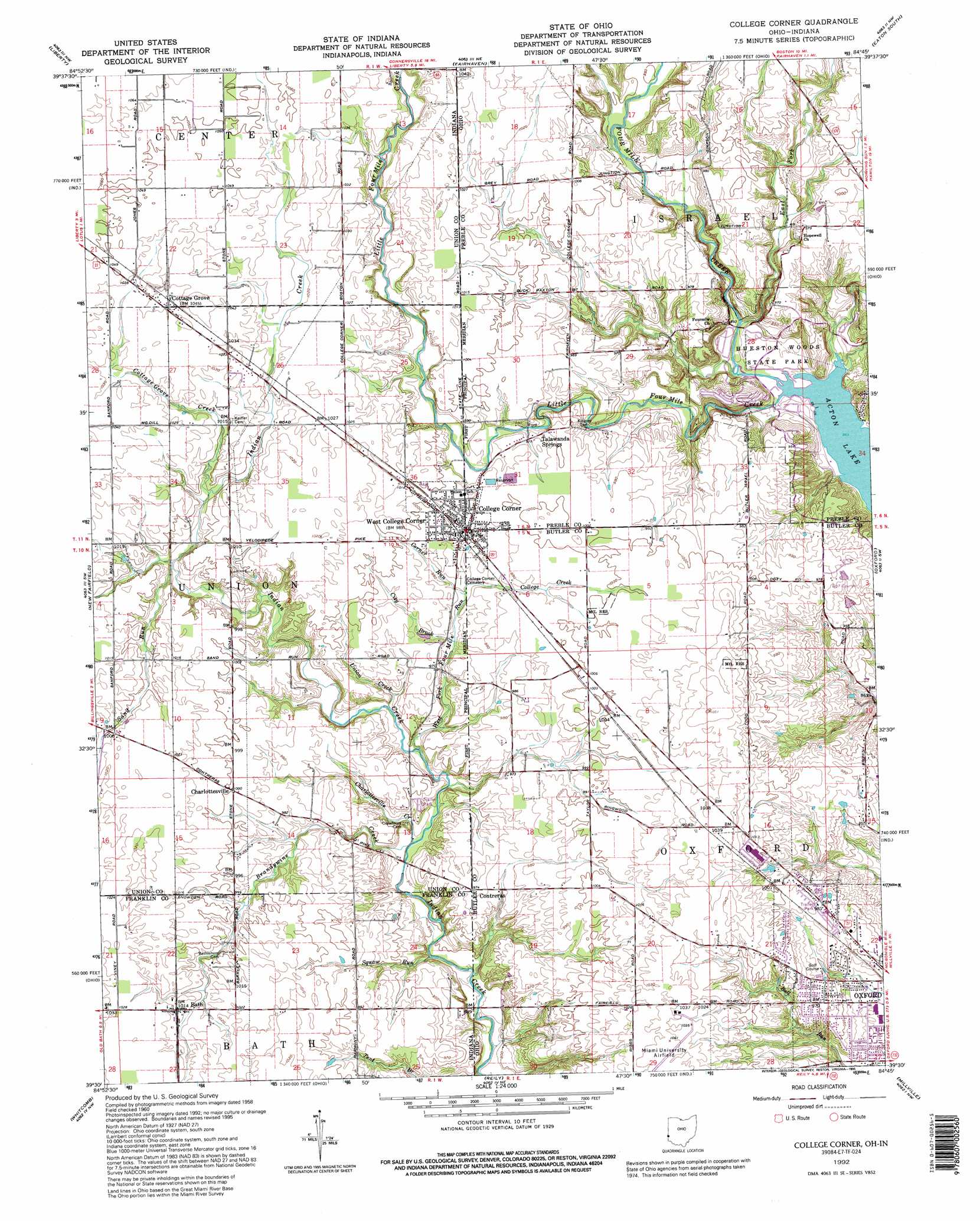
USGS Topo Quad 39084e7 - 1:24,000 scale
| Topo Map Name: | College Corner |
| USGS Topo Quad ID: | 39084e7 |
| Print Size: | ca. 21 1/4" wide x 27" high |
| Southeast Coordinates: | 39.5° N latitude / 84.75° W longitude |
| Map Center Coordinates: | 39.5625° N latitude / 84.8125° W longitude |
| U.S. States: | OH, IN |
| Filename: | o39084e7.jpg |
| Download Map JPG Image: | College Corner topo map 1:24,000 scale |
| Map Type: | Topographic |
| Topo Series: | 7.5´ |
| Map Scale: | 1:24,000 |
| Source of Map Images: | United States Geological Survey (USGS) |
| Alternate Map Versions: |
College Corner OH 1960, updated 1961 Download PDF Buy paper map College Corner OH 1960, updated 1970 Download PDF Buy paper map College Corner OH 1960, updated 1976 Download PDF Buy paper map College Corner OH 1960, updated 1990 Download PDF Buy paper map College Corner OH 1992, updated 1995 Download PDF Buy paper map College Corner OH 2010 Download PDF Buy paper map College Corner OH 2013 Download PDF Buy paper map College Corner OH 2016 Download PDF Buy paper map |
1:24,000 Topo Quads surrounding College Corner
Jacksonburg |
Richmond |
New Paris |
Eaton North |
Lewisburg |
Brownsville |
Liberty |
Fairhaven |
Eaton South |
West Alexandria |
Everton |
New Fairfield |
College Corner |
Oxford |
West Elkton |
Brookville |
Whitcomb |
Reily |
Millville |
Hamilton |
Spades |
Cedar Grove |
Harrison |
Shandon |
Greenhills |
> Back to 39084e1 at 1:100,000 scale
> Back to 39084a1 at 1:250,000 scale
> Back to U.S. Topo Maps home
College Corner topo map: Gazetteer
College Corner: Airports
Hueston Woods Lodge Heliport elevation 265m 869′Miami University Airport elevation 317m 1040′
College Corner: Parks
Hueston Woods State Nature Preserve elevation 289m 948′Oxford Park elevation 287m 941′
College Corner: Populated Places
Bath elevation 308m 1010′Charlottesville elevation 305m 1000′
College Corner elevation 299m 980′
Contreras elevation 293m 961′
Cottage Grove elevation 317m 1040′
McDonald (historical) elevation 315m 1033′
Talawanda Springs elevation 298m 977′
West College Corner elevation 301m 987′
College Corner: Post Offices
College Corner Post Office elevation 300m 984′Contreras Post Office (historical) elevation 296m 971′
Contreras Post Office (historical) elevation 292m 958′
College Corner: Streams
Brandywine Creek elevation 274m 898′Charlottesville Creek elevation 274m 898′
City Brook elevation 292m 958′
College Creek elevation 294m 964′
Corner Run elevation 295m 967′
Cottage Grove Creek elevation 299m 980′
East Fork Four Mile Creek elevation 277m 908′
Little Four Mile Creek elevation 263m 862′
Sand Run elevation 295m 967′
Squaw Run elevation 276m 905′
Union Creek elevation 286m 938′
West Fork Four Mile Run elevation 280m 918′
College Corner: Trails
Big Woods Trail elevation 287m 941′Blue Heron Hiking Trail elevation 283m 928′
Cabin Trail elevation 274m 898′
Cedar Falls Hiking Trail elevation 268m 879′
Equisetum Loop Trail elevation 295m 967′
Gallion Run Trail elevation 274m 898′
Hedge Apple Trail elevation 293m 961′
Indian Mound Trail elevation 293m 961′
Sugar Bush Trail elevation 278m 912′
Sycamore Hiking Trail elevation 266m 872′
College Corner: Woods
Hueston Woods elevation 274m 898′College Corner digital topo map on disk
Buy this College Corner topo map showing relief, roads, GPS coordinates and other geographical features, as a high-resolution digital map file on DVD:
Northern Illinois, Northern Indiana & Southwestern Michigan
Buy digital topo maps: Northern Illinois, Northern Indiana & Southwestern Michigan