Tipp City Topo Map Ohio
To zoom in, hover over the map of Tipp City
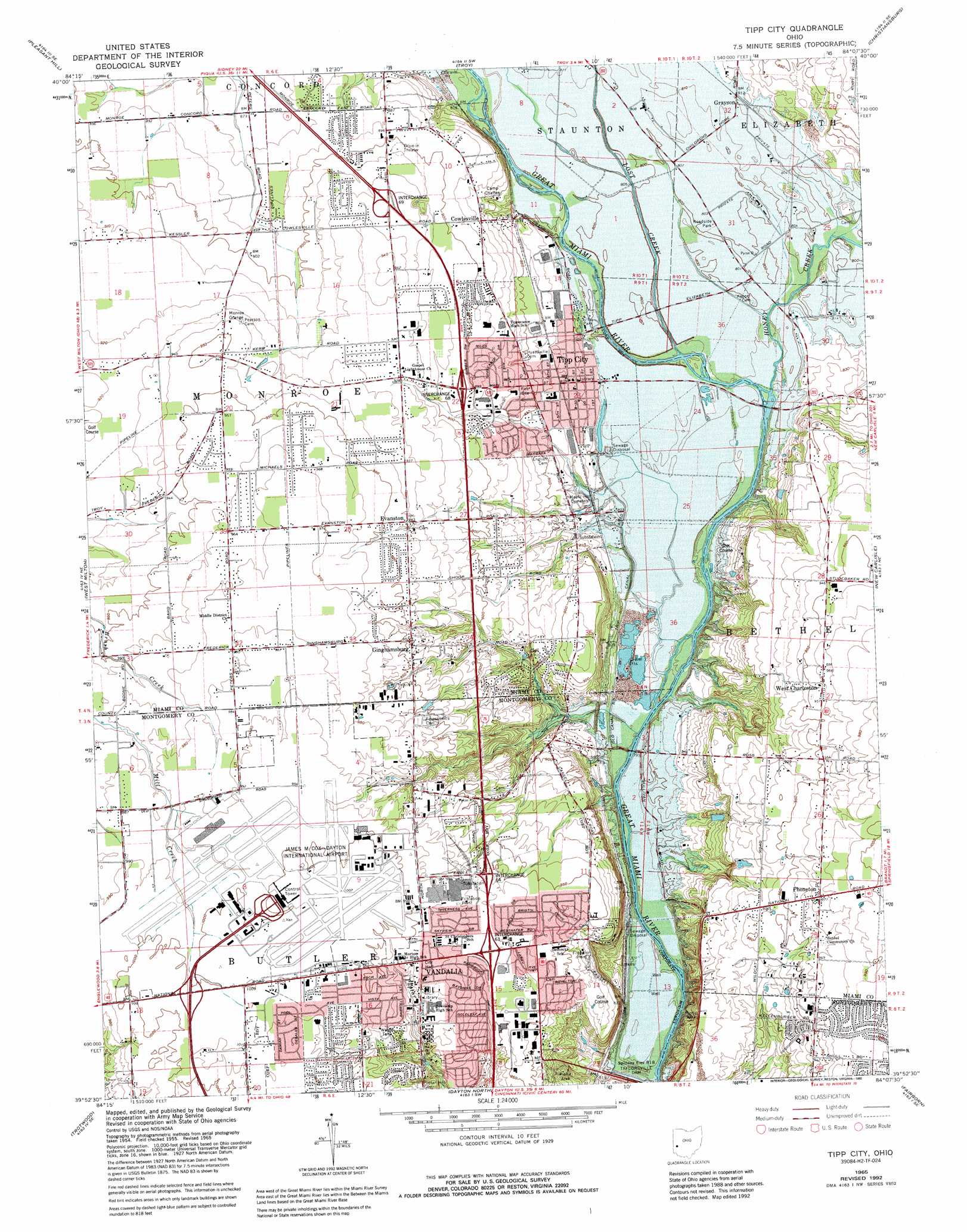
USGS Topo Quad 39084h2 - 1:24,000 scale
| Topo Map Name: | Tipp City |
| USGS Topo Quad ID: | 39084h2 |
| Print Size: | ca. 21 1/4" wide x 27" high |
| Southeast Coordinates: | 39.875° N latitude / 84.125° W longitude |
| Map Center Coordinates: | 39.9375° N latitude / 84.1875° W longitude |
| U.S. State: | OH |
| Filename: | o39084h2.jpg |
| Download Map JPG Image: | Tipp City topo map 1:24,000 scale |
| Map Type: | Topographic |
| Topo Series: | 7.5´ |
| Map Scale: | 1:24,000 |
| Source of Map Images: | United States Geological Survey (USGS) |
| Alternate Map Versions: |
Tipp City OH 1955, updated 1956 Download PDF Buy paper map Tipp City OH 1965, updated 1967 Download PDF Buy paper map Tipp City OH 1965, updated 1975 Download PDF Buy paper map Tipp City OH 1965, updated 1982 Download PDF Buy paper map Tipp City OH 1965, updated 1992 Download PDF Buy paper map Tipp City OH 2010 Download PDF Buy paper map Tipp City OH 2013 Download PDF Buy paper map Tipp City OH 2016 Download PDF Buy paper map |
1:24,000 Topo Quads surrounding Tipp City
Versailles |
Piqua West |
Piqua East |
Fletcher |
Saint Paris |
Gettysburg |
Pleasant Hill |
Troy |
Christiansburg |
Thackery |
Laura |
West Milton |
Tipp City |
New Carlisle |
Donnelsville |
Brookville |
Trotwood |
Dayton North |
Fairborn |
Yellow Springs |
Farmersville |
Miamisburg |
Dayton South |
Bellbrook |
Xenia |
> Back to 39084e1 at 1:100,000 scale
> Back to 39084a1 at 1:250,000 scale
> Back to U.S. Topo Maps home
Tipp City topo map: Gazetteer
Tipp City: Airports
Black Heliport elevation 272m 892′James M Cox Dayton International Airport elevation 305m 1000′
Tipp City: Areas
Freemans Prairie elevation 236m 774′Gerard Prairie elevation 244m 800′
Tipp City: Crossings
Interchange 63 elevation 297m 974′Interchange 64 elevation 292m 958′
Interchange 68 elevation 274m 898′
Interchange 69 elevation 283m 928′
Tipp City: Dams
Hart Pond Dam elevation 262m 859′Owen Pond Dam elevation 276m 905′
Tipp City: Parks
Charleston Falls Preserve elevation 273m 895′Hathaway Park elevation 261m 856′
Helke Park elevation 308m 1010′
Honey Creek Preserve elevation 240m 787′
Old Tippecanoe Main Street Historic District elevation 252m 826′
Robinette Park elevation 293m 961′
Thomas B Kyle Senior Memorial Park elevation 241m 790′
Tweed Park elevation 277m 908′
Victory Park elevation 302m 990′
Woodlawn Park elevation 282m 925′
Tipp City: Populated Places
Babbtown (historical) elevation 241m 790′Cowlesville elevation 269m 882′
Evanston elevation 287m 941′
Ginghamsburg elevation 289m 948′
Grayson elevation 247m 810′
Phoneton elevation 297m 974′
Tadmor (historical) elevation 242m 793′
Tipp City elevation 252m 826′
Vandalia elevation 303m 994′
West Charleston elevation 292m 958′
Tipp City: Post Offices
Ginghamsburg Post Office (historical) elevation 290m 951′Grayson Post Office (historical) elevation 247m 810′
Phoneton Post Office elevation 297m 974′
Tadmor Post Office (historical) elevation 246m 807′
Tipp City Post Office elevation 253m 830′
Tipp City Post Office elevation 264m 866′
Vandalia Post Office elevation 302m 990′
West Charleston Post Office (historical) elevation 293m 961′
Tipp City: Reservoirs
Hart Pond elevation 262m 859′Owen Pond elevation 276m 905′
Tipp City: Streams
Honey Creek elevation 240m 787′Lost Creek elevation 240m 787′
Tipp City digital topo map on disk
Buy this Tipp City topo map showing relief, roads, GPS coordinates and other geographical features, as a high-resolution digital map file on DVD:
Northern Illinois, Northern Indiana & Southwestern Michigan
Buy digital topo maps: Northern Illinois, Northern Indiana & Southwestern Michigan