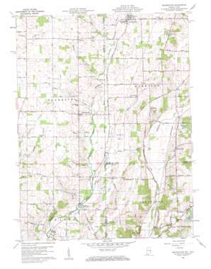
Whitewater Topo Map Indiana
To zoom in, hover over the map of Whitewater
USGS Topo Quad 39084h7 - 1:24,000 scale
| Topo Map Name: | Whitewater |
| USGS Topo Quad ID: | 39084h7 |
| Print Size: | ca. 21 1/4" wide x 27" high |
| Southeast Coordinates: | 39.875° N latitude / 84.75° W longitude |
| Map Center Coordinates: | 39.9375° N latitude / 84.8125° W longitude |
| U.S. States: | IN, OH |
| Filename: | o39084h7.jpg |
| Download Map JPG Image: | Whitewater topo map 1:24,000 scale |
| Map Type: | Topographic |
| Topo Series: | 7.5´ |
| Map Scale: | 1:24,000 |
| Source of Map Images: | United States Geological Survey (USGS) |
| Alternate Map Versions: |
Whitewater IN 1960, updated 1961 Download PDF Buy paper map Whitewater IN 1960, updated 1961 Download PDF Buy paper map Whitewater IN 1960, updated 1961 Download PDF Buy paper map Whitewater IN 2010 Download PDF Buy paper map Whitewater IN 2013 Download PDF Buy paper map Whitewater IN 2016 Download PDF Buy paper map |
1:24,000 Topo Quads surrounding Whitewater
> Back to 39084e1 at 1:100,000 scale
> Back to 39084a1 at 1:250,000 scale
> Back to U.S. Topo Maps home
Whitewater topo map: Gazetteer
Whitewater: Canals
Addleman Ditch elevation 344m 1128′Ross Ditch elevation 353m 1158′
Whitewater: Flats
Sunbeam Prairie elevation 329m 1079′Whitewater: Lakes
Marva Lakes elevation 347m 1138′Shadyview Lakes elevation 347m 1138′
Whitewater: Populated Places
Bethel elevation 369m 1210′Braffetsville elevation 352m 1154′
Hollansburg elevation 354m 1161′
Middleboro elevation 315m 1033′
Whitewater elevation 344m 1128′
Wiley (historical) elevation 332m 1089′
Whitewater: Post Offices
Hollansburg Post Office elevation 354m 1161′New Centre Post Office (historical) elevation 356m 1167′
Wiley Post Office (historical) elevation 333m 1092′
Whitewater: Streams
Bethel Creek elevation 336m 1102′Black Brook elevation 326m 1069′
Boro Brook elevation 313m 1026′
Brinley Fork elevation 336m 1102′
Clay Run elevation 321m 1053′
Dry Run elevation 314m 1030′
Evans Creek elevation 311m 1020′
Gray Brook elevation 344m 1128′
Gray Brook elevation 347m 1138′
Jocqueway Creek elevation 335m 1099′
Middle Brook elevation 318m 1043′
Middle Fork East Fork Whitewater River elevation 330m 1082′
Mud Creek elevation 317m 1040′
Mud Creek elevation 317m 1040′
Spring Run elevation 319m 1046′
Spring Run elevation 319m 1046′
White Creek elevation 331m 1085′
Whitewater digital topo map on disk
Buy this Whitewater topo map showing relief, roads, GPS coordinates and other geographical features, as a high-resolution digital map file on DVD:
Northern Illinois, Northern Indiana & Southwestern Michigan
Buy digital topo maps: Northern Illinois, Northern Indiana & Southwestern Michigan


