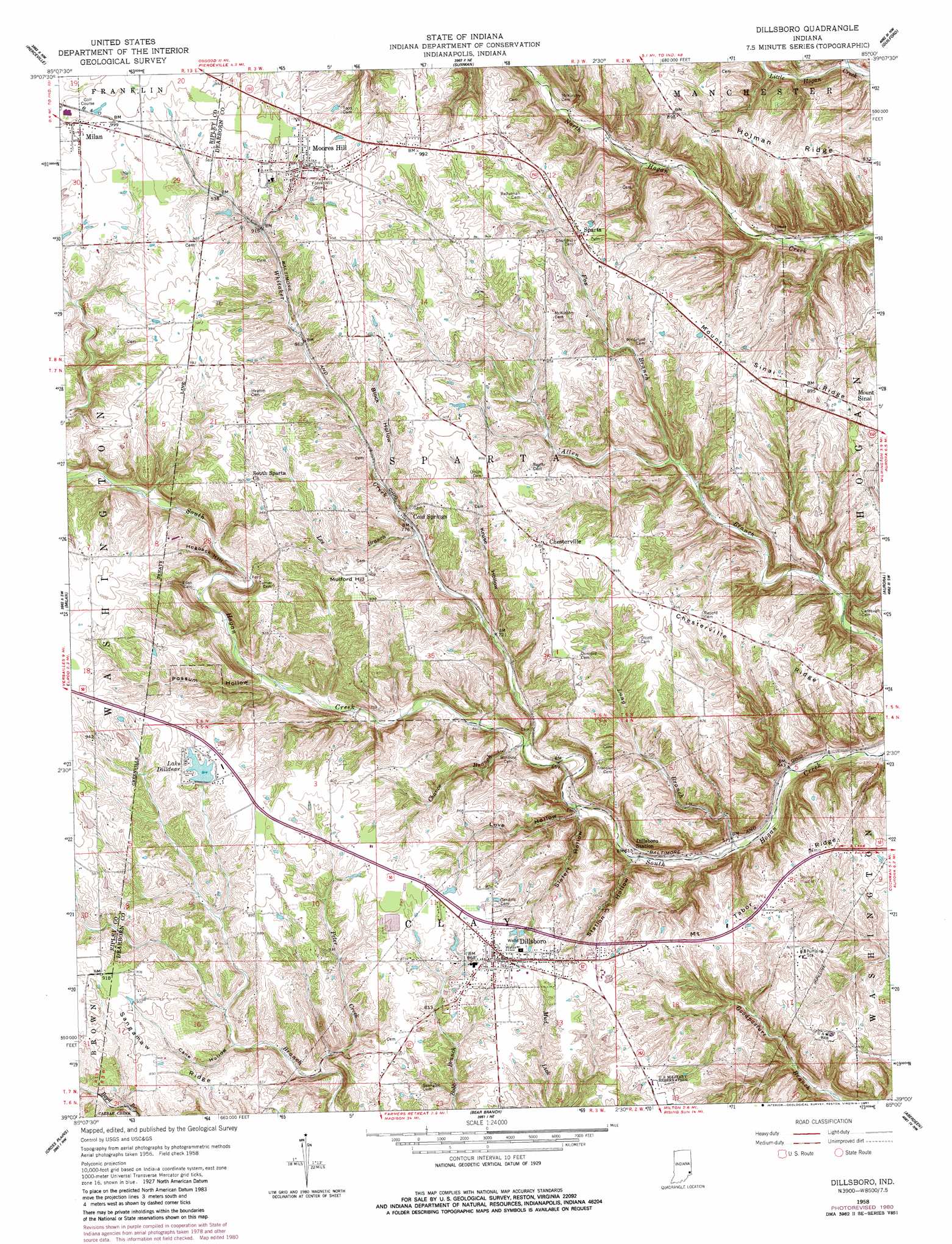
Dillsboro Topo Map Indiana
To zoom in, hover over the map of Dillsboro
USGS Topo Quad 39085a1 - 1:24,000 scale
| Topo Map Name: | Dillsboro |
| USGS Topo Quad ID: | 39085a1 |
| Print Size: | ca. 21 1/4" wide x 27" high |
| Southeast Coordinates: | 39° N latitude / 85° W longitude |
| Map Center Coordinates: | 39.0625° N latitude / 85.0625° W longitude |
| U.S. State: | IN |
| Filename: | o39085a1.jpg |
| Download Map JPG Image: | Dillsboro topo map 1:24,000 scale |
| Map Type: | Topographic |
| Topo Series: | 7.5´ |
| Map Scale: | 1:24,000 |
| Source of Map Images: | United States Geological Survey (USGS) |
| Alternate Map Versions: |
Dillsboro IN 1958, updated 1960 Download PDF Buy paper map Dillsboro IN 1958, updated 1981 Download PDF Buy paper map Dillsboro IN 1958, updated 1981 Download PDF Buy paper map Dillsboro IN 1992, updated 1995 Download PDF Buy paper map Dillsboro IN 2010 Download PDF Buy paper map Dillsboro IN 2013 Download PDF Buy paper map Dillsboro IN 2016 Download PDF Buy paper map |
1:24,000 Topo Quads surrounding Dillsboro
New Point |
Batesville |
Spades |
Cedar Grove |
Harrison |
Osgood |
Pierceville |
Sunman |
Guilford |
Hooven |
Versailles |
Milan |
Dillsboro |
Aurora |
Lawrenceburg |
Rexville |
Cross Plains |
Bear Branch |
Aberdeen |
Rising Sun |
Canaan |
Bennington |
Vevay North |
Florence |
Patriot |
> Back to 39085a1 at 1:100,000 scale
> Back to 39084a1 at 1:250,000 scale
> Back to U.S. Topo Maps home
Dillsboro topo map: Gazetteer
Dillsboro: Dams
Hough Lake Dam elevation 259m 849′Lake Dilldear Dam elevation 279m 915′
Meyer Lake Dam elevation 279m 915′
Dillsboro: Populated Places
Chesterville elevation 266m 872′Cold Springs elevation 240m 787′
Dillsboro elevation 265m 869′
Dillsboro Station elevation 186m 610′
Moores Hill elevation 302m 990′
Sparta elevation 279m 915′
Dillsboro: Reservoirs
Hough Lake elevation 259m 849′Lake Dilldear elevation 279m 915′
Dillsboro: Ridges
Chesterville Ridge elevation 253m 830′Hogback Hill elevation 262m 859′
Holman Ridge elevation 273m 895′
Sangamaw Ridge elevation 271m 889′
Dillsboro: Streams
Burton Branch elevation 190m 623′Chance Branch elevation 197m 646′
Fox Branch elevation 210m 688′
Lee Branch elevation 233m 764′
Long Branch elevation 169m 554′
Peter Creek elevation 216m 708′
Whitaker Creek elevation 195m 639′
Dillsboro: Summits
Mulford Hill elevation 280m 918′Dillsboro: Valleys
Cane Hollow elevation 231m 757′Kruse Hollow elevation 220m 721′
Love Hollow elevation 192m 629′
Possum Hollow elevation 223m 731′
Siefert Hollow elevation 189m 620′
Station Hollow elevation 179m 587′
Dillsboro digital topo map on disk
Buy this Dillsboro topo map showing relief, roads, GPS coordinates and other geographical features, as a high-resolution digital map file on DVD:
Northern Illinois, Northern Indiana & Southwestern Michigan
Buy digital topo maps: Northern Illinois, Northern Indiana & Southwestern Michigan