Brookville Topo Map Indiana
To zoom in, hover over the map of Brookville
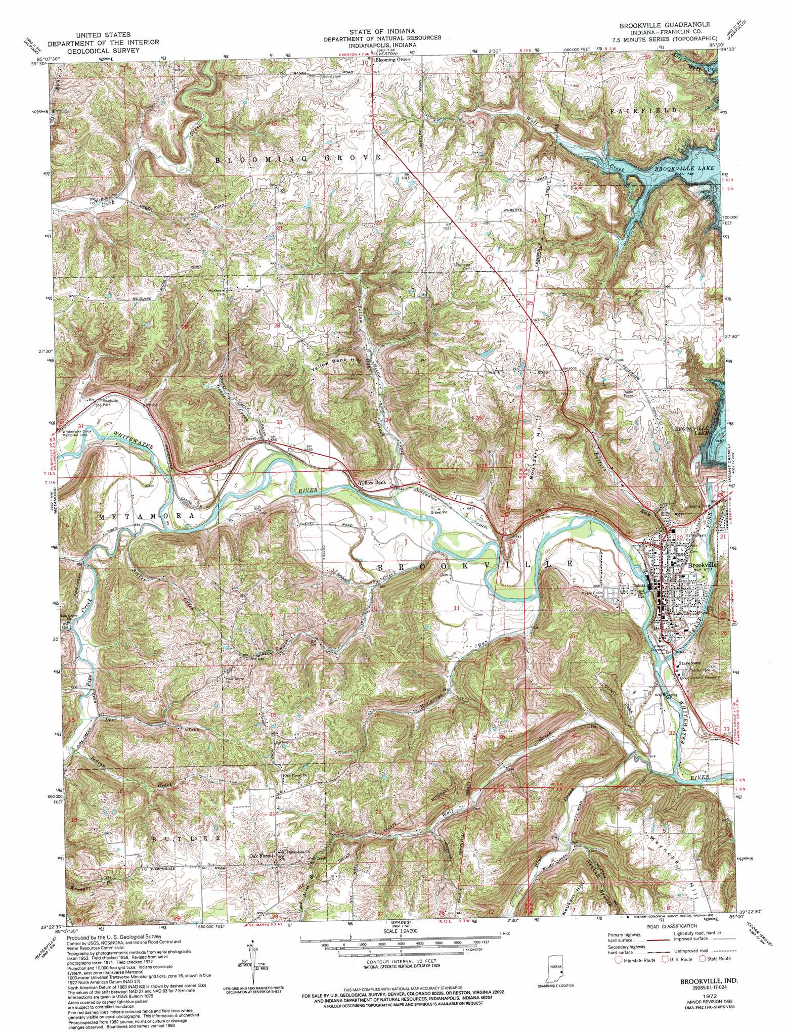
USGS Topo Quad 39085d1 - 1:24,000 scale
| Topo Map Name: | Brookville |
| USGS Topo Quad ID: | 39085d1 |
| Print Size: | ca. 21 1/4" wide x 27" high |
| Southeast Coordinates: | 39.375° N latitude / 85° W longitude |
| Map Center Coordinates: | 39.4375° N latitude / 85.0625° W longitude |
| U.S. State: | IN |
| Filename: | o39085d1.jpg |
| Download Map JPG Image: | Brookville topo map 1:24,000 scale |
| Map Type: | Topographic |
| Topo Series: | 7.5´ |
| Map Scale: | 1:24,000 |
| Source of Map Images: | United States Geological Survey (USGS) |
| Alternate Map Versions: |
Brookville IN 1956, updated 1957 Download PDF Buy paper map Brookville IN 1972, updated 1977 Download PDF Buy paper map Brookville IN 1972, updated 1993 Download PDF Buy paper map Brookville IN 2010 Download PDF Buy paper map Brookville IN 2013 Download PDF Buy paper map Brookville IN 2016 Download PDF Buy paper map |
1:24,000 Topo Quads surrounding Brookville
Falmouth |
Connersville |
Brownsville |
Liberty |
Fairhaven |
New Salem |
Alpine |
Everton |
New Fairfield |
College Corner |
Clarksburg |
Metamora |
Brookville |
Whitcomb |
Reily |
New Point |
Batesville |
Spades |
Cedar Grove |
Harrison |
Osgood |
Pierceville |
Sunman |
Guilford |
Hooven |
> Back to 39085a1 at 1:100,000 scale
> Back to 39084a1 at 1:250,000 scale
> Back to U.S. Topo Maps home
Brookville topo map: Gazetteer
Brookville: Canals
Whitewater Canal elevation 203m 666′Brookville: Dams
Whitewater Canal Memorial Lock elevation 204m 669′Brookville: Parks
Flood Victims Memorial elevation 190m 623′Whitewater Canal Memorial elevation 203m 666′
Brookville: Populated Places
Brookville elevation 203m 666′Millville elevation 232m 761′
Oak Forest elevation 295m 967′
Stavetown elevation 189m 620′
Yellow Bank elevation 198m 649′
Brookville: Streams
Blue Creek elevation 180m 590′Butlers Run elevation 185m 606′
Deer Creek elevation 203m 666′
Duck Creek elevation 201m 659′
East Fork Whitewater River elevation 186m 610′
East Fork Whitewater River elevation 185m 606′
Gates Creek elevation 197m 646′
Goose Creek elevation 196m 643′
Indian Creek elevation 204m 669′
Laurence Branch elevation 201m 659′
Long Acres Branch elevation 270m 885′
McCartys Run elevation 188m 616′
Pipe Creek elevation 196m 643′
Salt Well Creek elevation 228m 748′
Silver Creek elevation 198m 649′
Snail Creek elevation 189m 620′
Trace Branch elevation 201m 659′
Wolf Creek elevation 182m 597′
Wolf Creek elevation 228m 748′
Yellow Bank Creek elevation 192m 629′
Brookville: Summits
Boundary Hill elevation 305m 1000′Yellow Bank Hill elevation 298m 977′
Brookville digital topo map on disk
Buy this Brookville topo map showing relief, roads, GPS coordinates and other geographical features, as a high-resolution digital map file on DVD:
Northern Illinois, Northern Indiana & Southwestern Michigan
Buy digital topo maps: Northern Illinois, Northern Indiana & Southwestern Michigan