Boggstown Topo Map Indiana
To zoom in, hover over the map of Boggstown
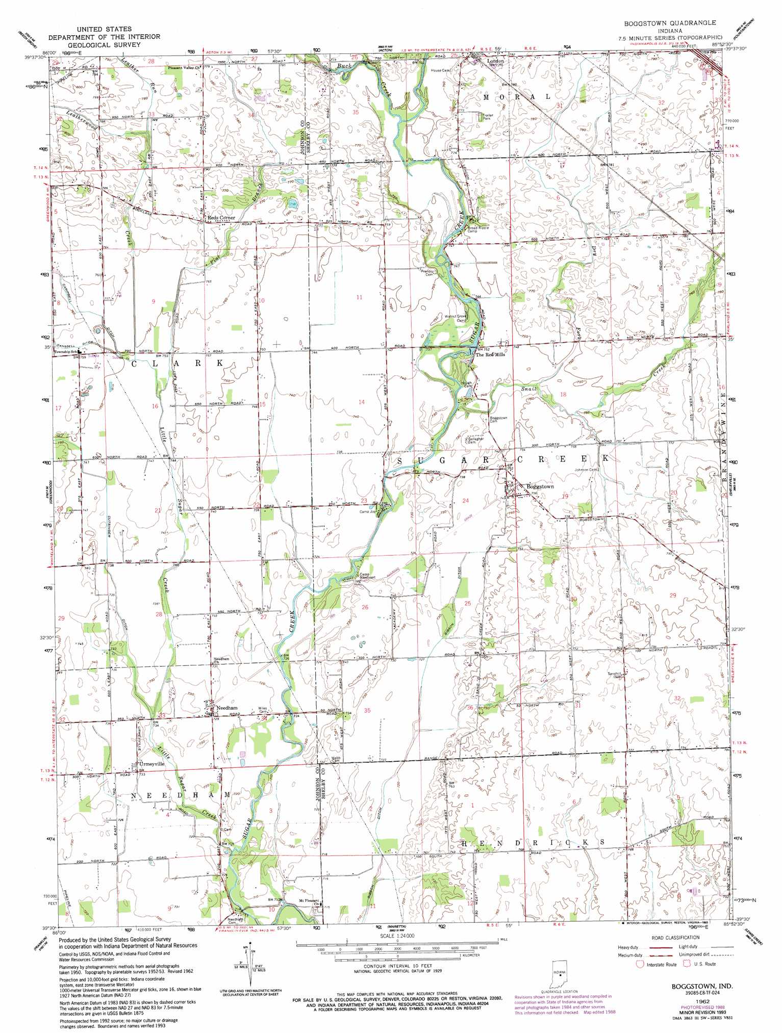
USGS Topo Quad 39085e8 - 1:24,000 scale
| Topo Map Name: | Boggstown |
| USGS Topo Quad ID: | 39085e8 |
| Print Size: | ca. 21 1/4" wide x 27" high |
| Southeast Coordinates: | 39.5° N latitude / 85.875° W longitude |
| Map Center Coordinates: | 39.5625° N latitude / 85.9375° W longitude |
| U.S. State: | IN |
| Filename: | o39085e8.jpg |
| Download Map JPG Image: | Boggstown topo map 1:24,000 scale |
| Map Type: | Topographic |
| Topo Series: | 7.5´ |
| Map Scale: | 1:24,000 |
| Source of Map Images: | United States Geological Survey (USGS) |
| Alternate Map Versions: |
Boggstown IN 1953, updated 1954 Download PDF Buy paper map Boggstown IN 1953, updated 1958 Download PDF Buy paper map Boggstown IN 1962, updated 1963 Download PDF Buy paper map Boggstown IN 1962, updated 1978 Download PDF Buy paper map Boggstown IN 1962, updated 1988 Download PDF Buy paper map Boggstown IN 1962, updated 1993 Download PDF Buy paper map Boggstown IN 2010 Download PDF Buy paper map Boggstown IN 2013 Download PDF Buy paper map Boggstown IN 2016 Download PDF Buy paper map |
1:24,000 Topo Quads surrounding Boggstown
Indianapolis West |
Indianapolis East |
Cumberland |
Greenfield |
Cleveland |
Maywood |
Beech Grove |
Acton |
Fountaintown |
Morristown |
Bargersville |
Greenwood |
Boggstown |
Shelbyville |
Rays Crossing |
Trafalgar |
Franklin |
Marietta |
Lewis Creek |
Waldron |
Beanblossom |
Nineveh |
Edinburgh |
Hope |
Hartsville |
> Back to 39085e1 at 1:100,000 scale
> Back to 39084a1 at 1:250,000 scale
> Back to U.S. Topo Maps home
Boggstown topo map: Gazetteer
Boggstown: Airports
Gray RLA Airport elevation 226m 741′Miller Airport elevation 223m 731′
Boggstown: Canals
Campbell Ditch elevation 232m 761′Cutsinger Ditch elevation 224m 734′
Ransdell Ditch elevation 231m 757′
Boggstown: Parks
Broad Ripple Camp elevation 228m 748′Camp Joy elevation 222m 728′
Camp Newheart elevation 220m 721′
Walnut Grove Camp elevation 226m 741′
Boggstown: Populated Places
Boggstown elevation 228m 748′Needham elevation 222m 728′
Reds Corner elevation 235m 770′
The Red Mills elevation 223m 731′
Urmeyville elevation 224m 734′
Boggstown: Post Offices
Fenns Post Office (historical) elevation 229m 751′Boggstown: Streams
Buck Creek elevation 229m 751′Dry Fork elevation 226m 741′
Flat Branch elevation 228m 748′
Leather Run elevation 236m 774′
Leatherwood Creek elevation 228m 748′
Little Sugar Creek elevation 217m 711′
Snail Creek elevation 221m 725′
West Little Sugar Creek elevation 229m 751′
Boggstown digital topo map on disk
Buy this Boggstown topo map showing relief, roads, GPS coordinates and other geographical features, as a high-resolution digital map file on DVD:
Northern Illinois, Northern Indiana & Southwestern Michigan
Buy digital topo maps: Northern Illinois, Northern Indiana & Southwestern Michigan