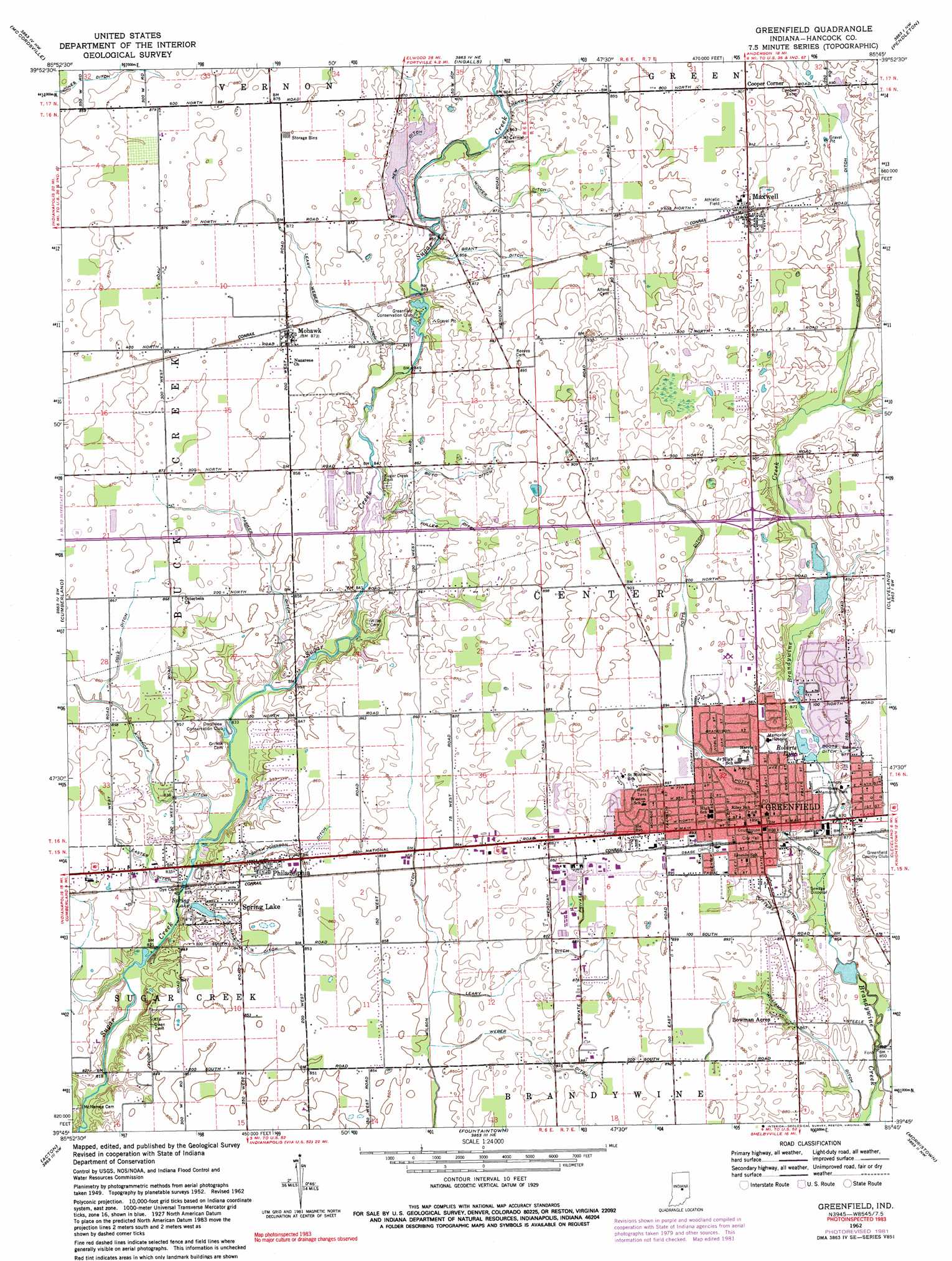
Greenfield Topo Map Indiana
To zoom in, hover over the map of Greenfield
USGS Topo Quad 39085g7 - 1:24,000 scale
| Topo Map Name: | Greenfield |
| USGS Topo Quad ID: | 39085g7 |
| Print Size: | ca. 21 1/4" wide x 27" high |
| Southeast Coordinates: | 39.75° N latitude / 85.75° W longitude |
| Map Center Coordinates: | 39.8125° N latitude / 85.8125° W longitude |
| U.S. State: | IN |
| Filename: | o39085g7.jpg |
| Download Map JPG Image: | Greenfield topo map 1:24,000 scale |
| Map Type: | Topographic |
| Topo Series: | 7.5´ |
| Map Scale: | 1:24,000 |
| Source of Map Images: | United States Geological Survey (USGS) |
| Alternate Map Versions: |
Greenfield IN 1952, updated 1953 Download PDF Buy paper map Greenfield IN 1962, updated 1964 Download PDF Buy paper map Greenfield IN 1962, updated 1977 Download PDF Buy paper map Greenfield IN 1962, updated 1982 Download PDF Buy paper map Greenfield IN 1962, updated 1990 Download PDF Buy paper map Greenfield IN 1962, updated 1990 Download PDF Buy paper map Greenfield IN 2010 Download PDF Buy paper map Greenfield IN 2013 Download PDF Buy paper map Greenfield IN 2016 Download PDF Buy paper map |
1:24,000 Topo Quads surrounding Greenfield
Noblesville |
Riverwood |
Lapel |
Anderson South |
Middletown |
Fishers |
Mccordsville |
Ingalls |
Pendleton |
Shirley |
Indianapolis East |
Cumberland |
Greenfield |
Cleveland |
Knightstown |
Beech Grove |
Acton |
Fountaintown |
Morristown |
Carthage |
Greenwood |
Boggstown |
Shelbyville |
Rays Crossing |
Manilla |
> Back to 39085e1 at 1:100,000 scale
> Back to 39084a1 at 1:250,000 scale
> Back to U.S. Topo Maps home
Greenfield topo map: Gazetteer
Greenfield: Canals
Boots Ditch elevation 266m 872′Boyd Ditch elevation 263m 862′
Brant Ditch elevation 262m 859′
Eastes Ditch elevation 253m 830′
Fuller Ditch elevation 263m 862′
Hall Ditch elevation 257m 843′
Henry Ditch elevation 262m 859′
Jones Ditch elevation 260m 853′
Kirkhoff Ditch elevation 254m 833′
Leary Ditch elevation 261m 856′
Leary Weber Ditch elevation 261m 856′
New Ditch elevation 259m 849′
Ogle Ditch elevation 262m 859′
Parker Ditch elevation 257m 843′
Potts Ditch elevation 270m 885′
Putter Ditch elevation 265m 869′
Richey Ditch elevation 268m 879′
Smith Johnson Ditch elevation 259m 849′
Weber Ditch elevation 263m 862′
Wicker Ditch elevation 261m 856′
Williamson Ditch elevation 261m 856′
Greenfield: Crossings
Interchange 104 elevation 278m 912′Greenfield: Dams
Sugar Hills Lake Dam elevation 260m 853′Greenfield: Lakes
Roberts Lake elevation 263m 862′Spring Lake elevation 255m 836′
Greenfield: Parks
Greenfield Courthouse Square Historic District elevation 269m 882′Riley Memorial Park elevation 269m 882′
Greenfield: Populated Places
Bowman Acres elevation 269m 882′Cooper Corner elevation 277m 908′
Greenfield elevation 269m 882′
Maxwell elevation 278m 912′
Mohawk elevation 265m 869′
Philadelphia elevation 259m 849′
Spring Lake elevation 259m 849′
Sugar Hills elevation 263m 862′
Greenfield: Post Offices
Greenfield Post Office elevation 268m 879′Greenfield: Streams
Little Brandywine Creek elevation 259m 849′Greenfield digital topo map on disk
Buy this Greenfield topo map showing relief, roads, GPS coordinates and other geographical features, as a high-resolution digital map file on DVD:
Northern Illinois, Northern Indiana & Southwestern Michigan
Buy digital topo maps: Northern Illinois, Northern Indiana & Southwestern Michigan