New Bellsville Topo Map Indiana
To zoom in, hover over the map of New Bellsville
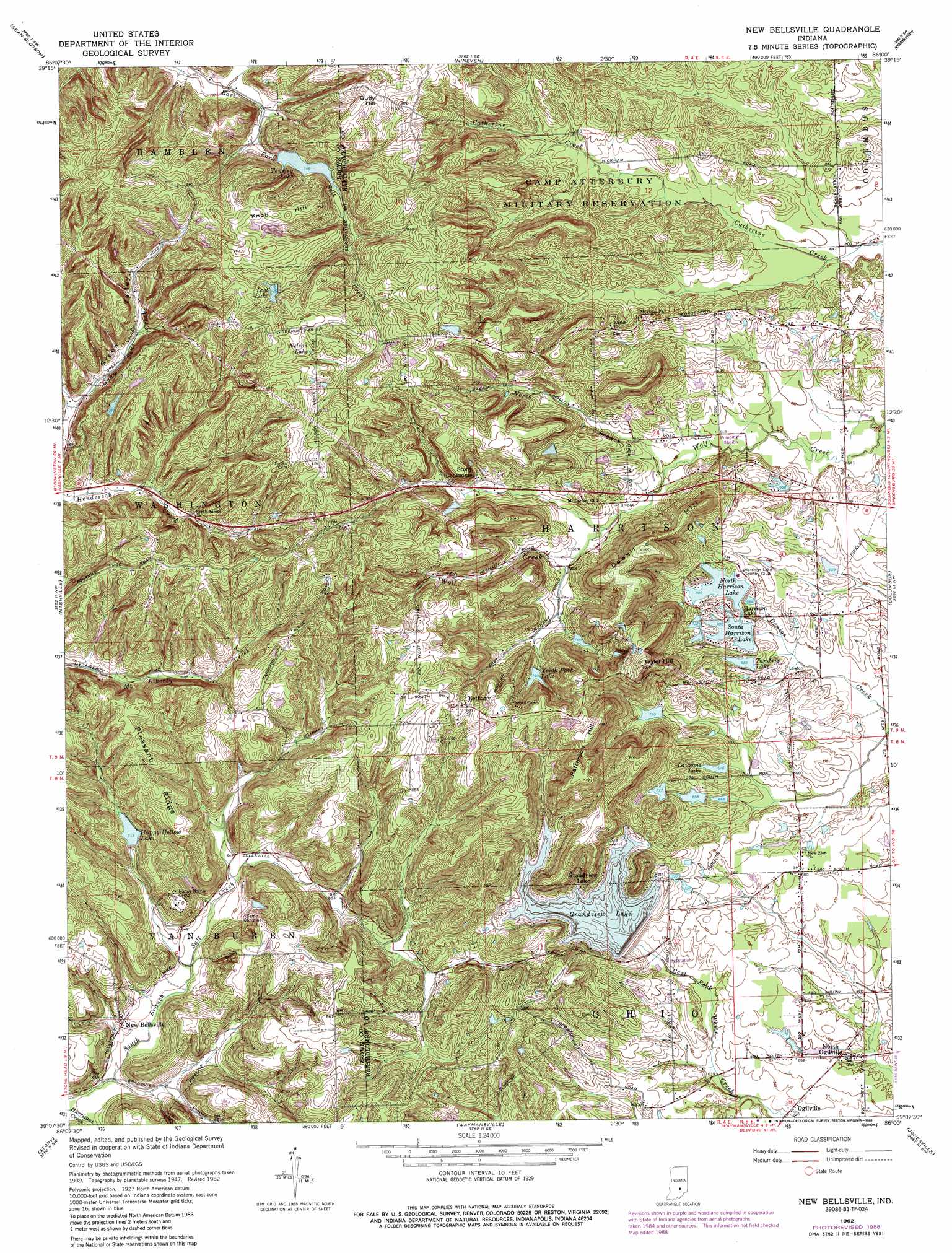
USGS Topo Quad 39086b1 - 1:24,000 scale
| Topo Map Name: | New Bellsville |
| USGS Topo Quad ID: | 39086b1 |
| Print Size: | ca. 21 1/4" wide x 27" high |
| Southeast Coordinates: | 39.125° N latitude / 86° W longitude |
| Map Center Coordinates: | 39.1875° N latitude / 86.0625° W longitude |
| U.S. State: | IN |
| Filename: | o39086b1.jpg |
| Download Map JPG Image: | New Bellsville topo map 1:24,000 scale |
| Map Type: | Topographic |
| Topo Series: | 7.5´ |
| Map Scale: | 1:24,000 |
| Source of Map Images: | United States Geological Survey (USGS) |
| Alternate Map Versions: |
New Bellsville IN 1948 Download PDF Buy paper map New Bellsville IN 1962, updated 1964 Download PDF Buy paper map New Bellsville IN 1962, updated 1967 Download PDF Buy paper map New Bellsville IN 1962, updated 1988 Download PDF Buy paper map New Bellsville IN 1962, updated 1988 Download PDF Buy paper map New Bellsville IN 2010 Download PDF Buy paper map New Bellsville IN 2013 Download PDF Buy paper map New Bellsville IN 2016 Download PDF Buy paper map |
1:24,000 Topo Quads surrounding New Bellsville
Cope |
Trafalgar |
Franklin |
Marietta |
Lewis Creek |
Morgantown |
Beanblossom |
Nineveh |
Edinburgh |
Hope |
Belmont |
Nashville |
New Bellsville |
Columbus |
Elizabethtown |
Elkinsville |
Story |
Waymansville |
Jonesville |
Azalia |
Norman |
Kurtz |
Brownstown |
Seymour |
Chestnut Ridge |
> Back to 39086a1 at 1:100,000 scale
> Back to 39086a1 at 1:250,000 scale
> Back to U.S. Topo Maps home
New Bellsville topo map: Gazetteer
New Bellsville: Dams
Camp Christina Lake Dam elevation 225m 738′Grandview Dam elevation 222m 728′
Harrison North Lake Dam elevation 213m 698′
Harrison South Lake Dam elevation 214m 702′
Jean Williamson Lake Dam elevation 261m 856′
Lawsons Lake Dam elevation 202m 662′
Staller Lake Dam elevation 210m 688′
Tamerix Lake Dam elevation 209m 685′
Thompson Lake Dam elevation 272m 892′
Youth Camp Lake Dam elevation 228m 748′
New Bellsville: Parks
Camp Christina elevation 213m 698′Happy Hollow Camp elevation 241m 790′
New Bellsville: Populated Places
Bethany elevation 273m 895′Grandview Lake elevation 232m 761′
Lake on the Green elevation 197m 646′
North Ogilville elevation 199m 652′
Ogilville elevation 193m 633′
Stony Lonesome elevation 222m 728′
Stratford (historical) elevation 252m 826′
New Bellsville: Reservoirs
Camp Christina Lake elevation 225m 738′Grandview Lake elevation 222m 728′
Happy Hollow Lake elevation 217m 711′
Harrison Lake elevation 214m 702′
Jean Williamson Lake elevation 261m 856′
Lawsons Lake elevation 202m 662′
Lost Lake elevation 265m 869′
Nelson Lake elevation 275m 902′
North Harrison Lake elevation 213m 698′
South Harrison Lake elevation 214m 702′
Staller Lake elevation 210m 688′
Tamerix Lake elevation 209m 685′
Thompson Lake elevation 272m 892′
Tousley Lake elevation 227m 744′
Youth Camp Lake elevation 228m 748′
New Bellsville: Ridges
Pleasant Ridge elevation 270m 885′New Bellsville: Streams
Hurricane Creek elevation 186m 610′North Branch Wolf Creek elevation 198m 649′
South Branch Salt Creek elevation 186m 610′
New Bellsville: Summits
Dowell Hill elevation 294m 964′Guffy Hill elevation 287m 941′
Knob Hill elevation 287m 941′
Patterson Hill elevation 299m 980′
Taylor Hill elevation 309m 1013′
New Bellsville digital topo map on disk
Buy this New Bellsville topo map showing relief, roads, GPS coordinates and other geographical features, as a high-resolution digital map file on DVD:
Northern Illinois, Northern Indiana & Southwestern Michigan
Buy digital topo maps: Northern Illinois, Northern Indiana & Southwestern Michigan