Nashville Topo Map Indiana
To zoom in, hover over the map of Nashville
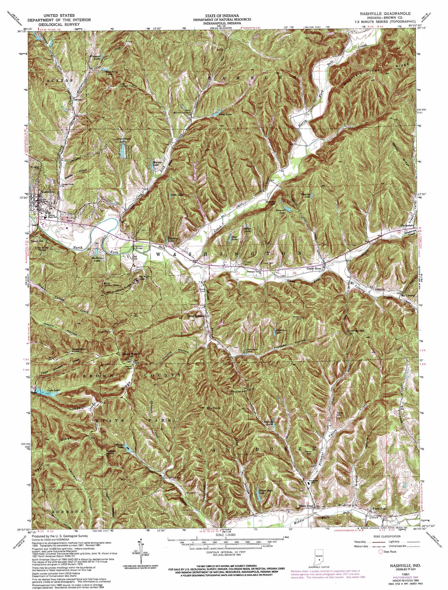
USGS Topo Quad 39086b2 - 1:24,000 scale
| Topo Map Name: | Nashville |
| USGS Topo Quad ID: | 39086b2 |
| Print Size: | ca. 21 1/4" wide x 27" high |
| Southeast Coordinates: | 39.125° N latitude / 86.125° W longitude |
| Map Center Coordinates: | 39.1875° N latitude / 86.1875° W longitude |
| U.S. State: | IN |
| Filename: | o39086b2.jpg |
| Download Map JPG Image: | Nashville topo map 1:24,000 scale |
| Map Type: | Topographic |
| Topo Series: | 7.5´ |
| Map Scale: | 1:24,000 |
| Source of Map Images: | United States Geological Survey (USGS) |
| Alternate Map Versions: |
Nashville IN 1947, updated 1960 Download PDF Buy paper map Nashville IN 1949 Download PDF Buy paper map Nashville IN 1961, updated 1963 Download PDF Buy paper map Nashville IN 1961, updated 1967 Download PDF Buy paper map Nashville IN 1961, updated 1981 Download PDF Buy paper map Nashville IN 1961, updated 1990 Download PDF Buy paper map Nashville IN 1961, updated 1994 Download PDF Buy paper map Nashville IN 1998, updated 2003 Download PDF Buy paper map Nashville IN 2010 Download PDF Buy paper map Nashville IN 2013 Download PDF Buy paper map Nashville IN 2016 Download PDF Buy paper map |
1:24,000 Topo Quads surrounding Nashville
Martinsville |
Cope |
Trafalgar |
Franklin |
Marietta |
Hindustan |
Morgantown |
Beanblossom |
Nineveh |
Edinburgh |
Unionville |
Belmont |
Nashville |
New Bellsville |
Columbus |
Allens Creek |
Elkinsville |
Story |
Waymansville |
Jonesville |
Bartlettsville |
Norman |
Kurtz |
Brownstown |
Seymour |
> Back to 39086a1 at 1:100,000 scale
> Back to 39086a1 at 1:250,000 scale
> Back to U.S. Topo Maps home
Nashville topo map: Gazetteer
Nashville: Capes
Five Points elevation 250m 820′Hesitation Point elevation 306m 1003′
Hohen Point elevation 306m 1003′
Nashville: Dams
Fleming Lake Dam elevation 236m 774′Greenbriar Lake Estates Dam elevation 204m 669′
Kahn Lake Dam elevation 265m 869′
Millers Lake Dam elevation 201m 659′
Nicewander Lake Dam elevation 216m 708′
Ogle Lake Dam elevation 217m 711′
Parkview Lake Dam elevation 191m 626′
Pfau Lake Dam elevation 227m 744′
Sage Lake Dam elevation 218m 715′
Silver Hook Lake Dam elevation 195m 639′
Stewart Lake Dam elevation 237m 777′
Strahl Lake Dam elevation 220m 721′
Willcraft Lake Lower Dam elevation 227m 744′
Nashville: Parks
Abe Martin Lodge elevation 233m 764′Camp Rancho Framasa elevation 210m 688′
Gnaw Bone Camp elevation 205m 672′
Nashville: Populated Places
Camp Roberts elevation 192m 629′Clarksdale elevation 207m 679′
Gnaw Bone elevation 195m 639′
Mount Liberty elevation 209m 685′
Pikes Peak elevation 183m 600′
Stone Head elevation 177m 580′
Town Hill elevation 242m 793′
Nashville: Reservoirs
Anderson Lake elevation 231m 757′Dawson Lake elevation 189m 620′
Fleming Lake elevation 236m 774′
Greenbriar Lake elevation 204m 669′
Kahn Lake elevation 265m 869′
Kimmins Lake elevation 213m 698′
Kreuger Lake elevation 221m 725′
Lake of the Clouds elevation 208m 682′
Long Lake elevation 222m 728′
Macabo Lake elevation 201m 659′
Miller Lake elevation 230m 754′
Millers Lake elevation 201m 659′
Nicewander Lake elevation 216m 708′
Ode Lake elevation 227m 744′
Ogle Lake elevation 217m 711′
Ortleib Lake elevation 208m 682′
Parkview Lake elevation 186m 610′
Pfau Lake elevation 227m 744′
Sage Lake elevation 218m 715′
Silver Hook Lake elevation 195m 639′
Stewart Lake elevation 237m 777′
Strahl Lake elevation 220m 721′
Nashville: Ridges
Kin Hubbard Ridge elevation 237m 777′Lester Ridge elevation 263m 862′
Limekiln Ridge elevation 312m 1023′
Mountain Tea Ridge elevation 281m 921′
Taylor Ridge elevation 296m 971′
Nashville: Streams
Clay Lick Creek elevation 182m 597′David Branch elevation 183m 600′
Gnaw Bone Creek elevation 183m 600′
Greasy Creek elevation 180m 590′
Greenhorn Creek elevation 181m 593′
Henderson Creek elevation 203m 666′
Mount Liberty Creek elevation 194m 636′
Pleasant Valley Creek elevation 177m 580′
Skinner Creek elevation 191m 626′
Nashville: Summits
Brown Hill elevation 265m 869′Downey Hill elevation 269m 882′
Seelmaer Hill elevation 261m 856′
Weed Patch Hill elevation 322m 1056′
Nashville: Valleys
Brand Hollow elevation 180m 590′Crouch Hollow elevation 204m 669′
Green Valley elevation 207m 679′
Pittman Hollow elevation 203m 666′
Reed Hollow elevation 178m 583′
Weddle Hollow elevation 189m 620′
Nashville digital topo map on disk
Buy this Nashville topo map showing relief, roads, GPS coordinates and other geographical features, as a high-resolution digital map file on DVD:
Northern Illinois, Northern Indiana & Southwestern Michigan
Buy digital topo maps: Northern Illinois, Northern Indiana & Southwestern Michigan