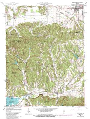
Morgantown Topo Map Indiana
To zoom in, hover over the map of Morgantown
USGS Topo Quad 39086c3 - 1:24,000 scale
| Topo Map Name: | Morgantown |
| USGS Topo Quad ID: | 39086c3 |
| Print Size: | ca. 21 1/4" wide x 27" high |
| Southeast Coordinates: | 39.25° N latitude / 86.25° W longitude |
| Map Center Coordinates: | 39.3125° N latitude / 86.3125° W longitude |
| U.S. State: | IN |
| Filename: | o39086c3.jpg |
| Download Map JPG Image: | Morgantown topo map 1:24,000 scale |
| Map Type: | Topographic |
| Topo Series: | 7.5´ |
| Map Scale: | 1:24,000 |
| Source of Map Images: | United States Geological Survey (USGS) |
| Alternate Map Versions: |
Morgantown IN 1948, updated 1956 Download PDF Buy paper map Morgantown IN 1950 Download PDF Buy paper map Morgantown IN 1961, updated 1963 Download PDF Buy paper map Morgantown IN 1961, updated 1968 Download PDF Buy paper map Morgantown IN 1961, updated 1981 Download PDF Buy paper map Morgantown IN 1961, updated 1987 Download PDF Buy paper map Morgantown IN 1961, updated 1987 Download PDF Buy paper map Morgantown IN 1998, updated 2002 Download PDF Buy paper map Morgantown IN 2010 Download PDF Buy paper map Morgantown IN 2013 Download PDF Buy paper map Morgantown IN 2016 Download PDF Buy paper map |
1:24,000 Topo Quads surrounding Morgantown
> Back to 39086a1 at 1:100,000 scale
> Back to 39086a1 at 1:250,000 scale
> Back to U.S. Topo Maps home
Morgantown topo map: Gazetteer
Morgantown: Airports
Kenstin Manor Airport elevation 198m 649′Morgantown: Dams
Autumn Lake Dam elevation 254m 833′Baker Lake Dam elevation 257m 843′
Bardonner Lake Dam elevation 233m 764′
Bear Lake Dam elevation 245m 803′
Bear Lodge Lake Dam elevation 250m 820′
Cull Lake Dam elevation 221m 725′
Edward Lewis Lake Dam elevation 225m 738′
Fineburg Lake Dam elevation 234m 767′
Gallahue Lake Dam elevation 233m 764′
Hungry Acres Lake Dam elevation 272m 892′
Kelly Lake Dam elevation 259m 849′
Kirkofer Lake Dam elevation 232m 761′
Lake Lasalle Dam elevation 233m 764′
Lutheran Church Camp Dam elevation 203m 666′
Merriman Lake Dam elevation 252m 826′
Rorack Lake Dam elevation 222m 728′
Shady Oaks Lake Dam elevation 228m 748′
Stockton Lake Dam elevation 223m 731′
Morgantown: Parks
Gallahue Valley Camp elevation 239m 784′Morgantown: Populated Places
Bear Wallow elevation 291m 954′Cornelius elevation 217m 711′
Fruitdale elevation 258m 846′
Helmsburg elevation 203m 666′
Hickman's Trailer Park elevation 207m 679′
Mahalasville elevation 192m 629′
Morgantown elevation 207m 679′
Needmore elevation 221m 725′
Point Idalawn elevation 203m 666′
Trevlac elevation 195m 639′
Waycross elevation 216m 708′
Morgantown: Reservoirs
Autumn Lake elevation 254m 833′Baker Lake elevation 257m 843′
Bardonner Lake elevation 233m 764′
Bear Lake elevation 245m 803′
Bear Lodge Lake elevation 250m 820′
Cull Lake elevation 221m 725′
Echo Lake elevation 230m 754′
Fineburg Lake elevation 234m 767′
Gallahue Lake elevation 233m 764′
Hungry Acres Lake elevation 272m 892′
Kelly Lake elevation 259m 849′
Kirkofer Lake elevation 232m 761′
Lake LaSalle elevation 233m 764′
LaSalle Lake elevation 231m 757′
Linger Longer Lake elevation 198m 649′
Lutheran Hills Lake elevation 203m 666′
Merriman Lake elevation 252m 826′
Rorack Lake elevation 222m 728′
Shady Oaks Lake elevation 228m 748′
Stockton Lake elevation 223m 731′
Morgantown: Ridges
Carmel Ridge elevation 266m 872′Oak Ridge elevation 255m 836′
Morgantown: Streams
Bear Creek elevation 193m 633′Bear Creek elevation 200m 656′
Bell Creek elevation 203m 666′
Big Thunder Creek elevation 210m 688′
Brier Creek elevation 195m 639′
Camp Creek elevation 186m 610′
Crooked Creek elevation 195m 639′
Dunnaway Creek elevation 201m 659′
Hoppers Branch elevation 204m 669′
Indian Trace Creek elevation 192m 629′
Jack Creek elevation 204m 669′
Lick Creek elevation 198m 649′
Long Run elevation 198m 649′
North Fork Beanblossom Creek elevation 201m 659′
Oliver Creek elevation 195m 639′
Opossum Run elevation 273m 895′
Pike Creek elevation 195m 639′
Plum Creek elevation 193m 633′
Morgantown: Summits
Cooks Hill elevation 292m 958′Morgantown digital topo map on disk
Buy this Morgantown topo map showing relief, roads, GPS coordinates and other geographical features, as a high-resolution digital map file on DVD:
Northern Illinois, Northern Indiana & Southwestern Michigan
Buy digital topo maps: Northern Illinois, Northern Indiana & Southwestern Michigan


