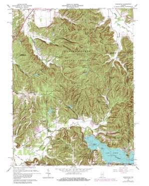
Hindustan Topo Map Indiana
To zoom in, hover over the map of Hindustan
USGS Topo Quad 39086c4 - 1:24,000 scale
| Topo Map Name: | Hindustan |
| USGS Topo Quad ID: | 39086c4 |
| Print Size: | ca. 21 1/4" wide x 27" high |
| Southeast Coordinates: | 39.25° N latitude / 86.375° W longitude |
| Map Center Coordinates: | 39.3125° N latitude / 86.4375° W longitude |
| U.S. State: | IN |
| Filename: | o39086c4.jpg |
| Download Map JPG Image: | Hindustan topo map 1:24,000 scale |
| Map Type: | Topographic |
| Topo Series: | 7.5´ |
| Map Scale: | 1:24,000 |
| Source of Map Images: | United States Geological Survey (USGS) |
| Alternate Map Versions: |
Hindustan IN 1948 Download PDF Buy paper map Hindustan IN 1948 Download PDF Buy paper map Hindustan IN 1961, updated 1963 Download PDF Buy paper map Hindustan IN 1961, updated 1966 Download PDF Buy paper map Hindustan IN 1961, updated 1981 Download PDF Buy paper map Hindustan IN 1961, updated 1981 Download PDF Buy paper map Hindustan IN 2010 Download PDF Buy paper map Hindustan IN 2013 Download PDF Buy paper map Hindustan IN 2016 Download PDF Buy paper map |
1:24,000 Topo Quads surrounding Hindustan
> Back to 39086a1 at 1:100,000 scale
> Back to 39086a1 at 1:250,000 scale
> Back to U.S. Topo Maps home
Hindustan topo map: Gazetteer
Hindustan: Capes
Reed Point elevation 193m 633′Riddle Point elevation 193m 633′
Hindustan: Dams
Bean Blossom Dam elevation 214m 702′Bryant Creek Lake Dam elevation 217m 711′
Cherry Lake Dam elevation 278m 912′
Egenolf Lake Dam elevation 196m 643′
Lazy Lake Dam elevation 193m 633′
Hindustan: Gaps
Low Gap elevation 254m 833′Hindustan: Islands
Cemetery Island elevation 192m 629′Hindustan: Parks
Mason Ridge Camping Area elevation 285m 935′Oak Ridge Camping Area elevation 275m 902′
Hindustan: Populated Places
Fleener elevation 193m 633′Hindustan elevation 260m 853′
Turkey Track elevation 240m 787′
Hindustan: Post Offices
Monroe Mills Post Office (historical) elevation 277m 908′Hindustan: Reservoirs
Beanblossom Lake elevation 203m 666′Bryant Creek Lake elevation 217m 711′
Cherry Lake elevation 262m 859′
Egenolf Lake elevation 196m 643′
Lake Lemon elevation 189m 620′
Lazy Lake elevation 193m 633′
Hindustan: Ridges
Cracky Ridge elevation 246m 807′Farr Ridge elevation 269m 882′
Gorley Ridge elevation 282m 925′
Hatfield Ridge elevation 269m 882′
Ira Hacker Ridge elevation 263m 862′
Landram Ridge elevation 277m 908′
Mason Ridge elevation 281m 921′
Meetinghouse Ridge elevation 280m 918′
Pea Ridge elevation 268m 879′
Persimmon Ridge elevation 257m 843′
Peters Ridge elevation 259m 849′
Precint Ridge elevation 260m 853′
Reynolds Ridge elevation 279m 915′
Shipman Ridge elevation 288m 944′
Tincher Ridge elevation 266m 872′
Hindustan: Streams
Buck Creek elevation 176m 577′East Fork Honey Creek elevation 198m 649′
Gose Creek elevation 183m 600′
Greasy Creek elevation 183m 600′
Honey Creek elevation 183m 600′
Lazy Creek elevation 180m 590′
North Fork Honey Creek elevation 193m 633′
Rapid Creek elevation 193m 633′
Robertson Creek elevation 186m 610′
Strickland Branch elevation 191m 626′
Wolf Creek elevation 183m 600′
Hindustan: Summits
Bald Knob elevation 253m 830′Hindustan: Trails
Three Lakes Trail elevation 252m 826′Hindustan: Valleys
Beecher Hollow elevation 188m 616′Bud Davis Hollow elevation 195m 639′
Deadman Hollow elevation 193m 633′
Green Hollow elevation 195m 639′
Happy Hollow elevation 195m 639′
Robinson Hollow elevation 187m 613′
Sweedy Hollow elevation 186m 610′
Hindustan digital topo map on disk
Buy this Hindustan topo map showing relief, roads, GPS coordinates and other geographical features, as a high-resolution digital map file on DVD:
Northern Illinois, Northern Indiana & Southwestern Michigan
Buy digital topo maps: Northern Illinois, Northern Indiana & Southwestern Michigan


