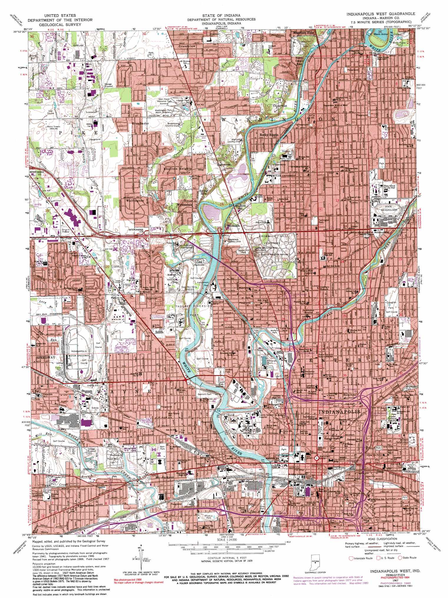
Indianapolis West Topo Map Indiana
To zoom in, hover over the map of Indianapolis West
USGS Topo Quad 39086g2 - 1:24,000 scale
| Topo Map Name: | Indianapolis West |
| USGS Topo Quad ID: | 39086g2 |
| Print Size: | ca. 21 1/4" wide x 27" high |
| Southeast Coordinates: | 39.75° N latitude / 86.125° W longitude |
| Map Center Coordinates: | 39.8125° N latitude / 86.1875° W longitude |
| U.S. State: | IN |
| Filename: | o39086g2.jpg |
| Download Map JPG Image: | Indianapolis West topo map 1:24,000 scale |
| Map Type: | Topographic |
| Topo Series: | 7.5´ |
| Map Scale: | 1:24,000 |
| Source of Map Images: | United States Geological Survey (USGS) |
| Alternate Map Versions: |
Indianapolis West IN 1948 Download PDF Buy paper map Indianapolis West IN 1959, updated 1961 Download PDF Buy paper map Indianapolis West IN 1967, updated 1969 Download PDF Buy paper map Indianapolis West IN 1967, updated 1970 Download PDF Buy paper map Indianapolis West IN 1967, updated 1981 Download PDF Buy paper map Indianapolis West IN 1967, updated 1991 Download PDF Buy paper map Indianapolis West IN 1967, updated 1991 Download PDF Buy paper map Indianapolis West IN 1998, updated 2002 Download PDF Buy paper map Indianapolis West IN 2010 Download PDF Buy paper map Indianapolis West IN 2013 Download PDF Buy paper map Indianapolis West IN 2016 Download PDF Buy paper map |
1:24,000 Topo Quads surrounding Indianapolis West
Lebanon |
Rosston |
Westfield |
Noblesville |
Riverwood |
Fayette |
Zionsville |
Carmel |
Fishers |
Mccordsville |
Brownsburg |
Clermont |
Indianapolis West |
Indianapolis East |
Cumberland |
Plainfield |
Bridgeport |
Maywood |
Beech Grove |
Acton |
Mooresville West |
Mooresville East |
Bargersville |
Greenwood |
Boggstown |
> Back to 39086e1 at 1:100,000 scale
> Back to 39086a1 at 1:250,000 scale
> Back to U.S. Topo Maps home
Indianapolis West topo map: Gazetteer
Indianapolis West: Airports
500 Airport elevation 219m 718′Indiana Department of Natural Resources Airport elevation 212m 695′
Indianapolis Downtown Airport elevation 229m 751′
ISHC Landing Pad elevation 216m 708′
Lafayette Square Airfield elevation 232m 761′
Methodist Hospital Helistop elevation 220m 721′
North Westway Park Airport elevation 244m 800′
Indianapolis West: Canals
Colbertson Ditch elevation 220m 721′Culbertson Ditch elevation 219m 718′
Dry Run Diverson Ditch elevation 225m 738′
Indianapolis Water Company Canal elevation 218m 715′
Maibucker Ditch elevation 221m 725′
Meyers Ditch elevation 227m 744′
Indianapolis West: Crossings
Interchange 110 elevation 223m 731′Interchange 111 elevation 223m 731′
Interchange 114 elevation 228m 748′
Interchange 115 elevation 223m 731′
Interchange 116 elevation 225m 738′
Interchange 117 elevation 224m 734′
Interchange 119 elevation 228m 748′
Interchange 77 elevation 224m 734′
Interchange 78 elevation 218m 715′
Interchange 79 elevation 219m 718′
Interchange 80 elevation 216m 708′
Interchange 83 elevation 225m 738′
Indianapolis West: Lakes
Lake Sullivan elevation 212m 695′Indianapolis West: Parks
A J Thatcher Park elevation 217m 711′Arsenal Park elevation 226m 741′
Bahr Park elevation 214m 702′
Bloch Park elevation 214m 702′
Broad Ripple Park elevation 222m 728′
Bush Stadium elevation 212m 695′
Butler Athletic Fields elevation 214m 702′
Centennial And 20th Street Park elevation 224m 734′
Centennial And Goff Park elevation 225m 738′
Chuck Klein Softball Complex elevation 221m 725′
Convention Center Plaza elevation 217m 711′
Davey Athletic Complex elevation 218m 715′
East Mall elevation 232m 761′
Fall Creek And 16th Street Park elevation 216m 708′
Frank Young Park elevation 220m 721′
Friedmann Park elevation 218m 715′
Golden Hill Park elevation 232m 761′
Hill Park elevation 220m 721′
Holcomb Gardens elevation 218m 715′
Holliday Park elevation 239m 784′
Indiana World War Memorial elevation 219m 718′
Indianola Park elevation 214m 702′
James Whitcomb Riley Monument elevation 237m 777′
Kuntz Stadium elevation 214m 702′
Major Taylor Velodrome Park elevation 213m 698′
Martin Luther King Memorial Park elevation 220m 721′
McCarty Triangle Park elevation 208m 682′
Memorial Plaza elevation 218m 715′
Military Park elevation 215m 705′
Monument Circle elevation 219m 718′
Moreland Park elevation 224m 734′
Norris Plaza elevation 232m 761′
North Mall elevation 231m 757′
North Meridian Street Historic District elevation 224m 734′
North Park elevation 223m 731′
Old Northside Historic District elevation 220m 721′
Pan American Plaza elevation 216m 708′
RCA Dome (historical) elevation 216m 708′
Reverend Mozel Sanders Park elevation 212m 695′
Rhodius Park elevation 209m 685′
Ridenour Park elevation 215m 705′
Riley Park elevation 212m 695′
Saint Francis Colonnade elevation 226m 741′
Sixtyfirst And Broadway Park elevation 220m 721′
Soldiers and Sailors Monument elevation 219m 718′
South Mall elevation 233m 764′
Taggart Riverside Park elevation 212m 695′
Tarkington Park elevation 224m 734′
Tibbs And 21st Street Park elevation 224m 734′
University Park elevation 219m 718′
Victory Field elevation 212m 695′
Victory Field elevation 213m 698′
Watkins Park elevation 216m 708′
West Mall elevation 233m 764′
White River State Park elevation 212m 695′
Willard Park elevation 230m 754′
Indianapolis West: Populated Places
Belmont elevation 214m 702′Broad Ripple elevation 221m 725′
Broad Ripple elevation 225m 738′
Broadmoor elevation 235m 770′
Brooklyn Heights elevation 224m 734′
Clifton elevation 228m 748′
Crows Nest elevation 236m 774′
Fairview Station elevation 216m 708′
Flackville elevation 225m 738′
Glendale elevation 218m 715′
Grandview elevation 239m 784′
Highwoods elevation 235m 770′
Indianapolis elevation 219m 718′
Knollton Heights elevation 232m 761′
Lynhurst elevation 226m 741′
Mapleton elevation 231m 757′
Mount Jackson elevation 214m 702′
North Crows Nest elevation 238m 780′
North Indianapolis elevation 222m 728′
Rocky Ripple elevation 215m 705′
Shooters Hill elevation 232m 761′
Spring Hills elevation 233m 764′
Wellington elevation 219m 718′
Wolfington elevation 229m 751′
Woodruff Place elevation 228m 748′
Woodstock elevation 233m 764′
Wynnedale elevation 231m 757′
Indianapolis West: Post Offices
Circle City Station Indianapolis Post Office elevation 218m 715′Indianapolis Post Office elevation 214m 702′
Rainbow Station Indianapolis Post Office elevation 223m 731′
Indianapolis West: Streams
Augusta Branch elevation 241m 790′Bird Branch elevation 247m 810′
Crooked Creek elevation 216m 708′
Culver Branch elevation 231m 757′
Dry Run elevation 219m 718′
Falcon Creek elevation 219m 718′
Fall Creek elevation 206m 675′
Guion Creek elevation 231m 757′
Hatchery Creek elevation 214m 702′
Highwood Branch elevation 212m 695′
Lacy Branch elevation 225m 738′
Little Eagle Creek elevation 212m 695′
Lynn Creek elevation 218m 715′
Mill Run elevation 213m 698′
Pogues Run elevation 220m 721′
Ristow Branch elevation 212m 695′
Robin Run elevation 246m 807′
Indianapolis West: Swamps
Bacon Swamp elevation 223m 731′Indianapolis West digital topo map on disk
Buy this Indianapolis West topo map showing relief, roads, GPS coordinates and other geographical features, as a high-resolution digital map file on DVD:
Northern Illinois, Northern Indiana & Southwestern Michigan
Buy digital topo maps: Northern Illinois, Northern Indiana & Southwestern Michigan