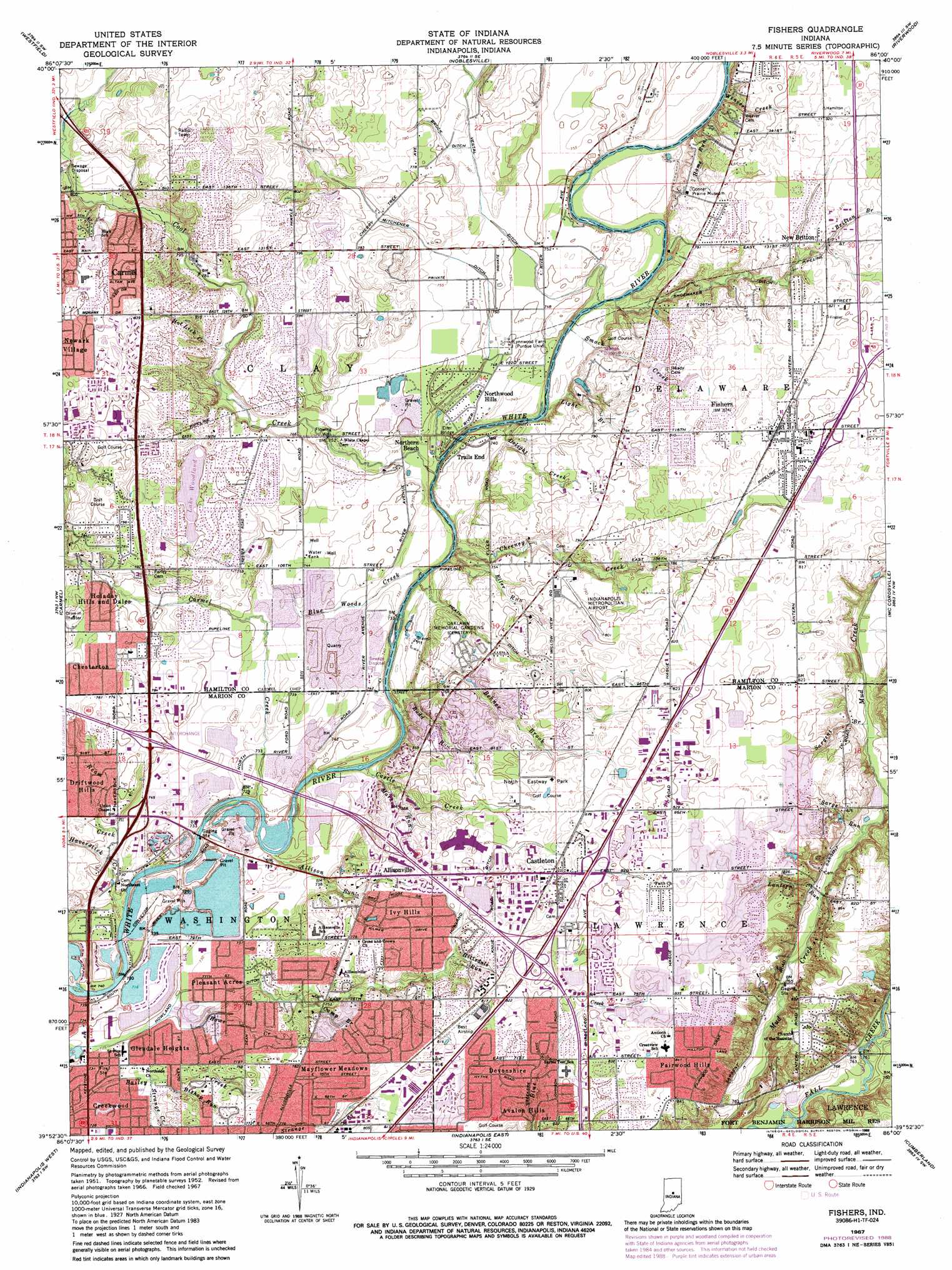
Fishers Topo Map Indiana
To zoom in, hover over the map of Fishers
USGS Topo Quad 39086h1 - 1:24,000 scale
| Topo Map Name: | Fishers |
| USGS Topo Quad ID: | 39086h1 |
| Print Size: | ca. 21 1/4" wide x 27" high |
| Southeast Coordinates: | 39.875° N latitude / 86° W longitude |
| Map Center Coordinates: | 39.9375° N latitude / 86.0625° W longitude |
| U.S. State: | IN |
| Filename: | o39086h1.jpg |
| Download Map JPG Image: | Fishers topo map 1:24,000 scale |
| Map Type: | Topographic |
| Topo Series: | 7.5´ |
| Map Scale: | 1:24,000 |
| Source of Map Images: | United States Geological Survey (USGS) |
| Alternate Map Versions: |
Fishers IN 1952, updated 1953 Download PDF Buy paper map Fishers IN 1959, updated 1960 Download PDF Buy paper map Fishers IN 1959, updated 1967 Download PDF Buy paper map Fishers IN 1967, updated 1969 Download PDF Buy paper map Fishers IN 1967, updated 1980 Download PDF Buy paper map Fishers IN 1967, updated 1988 Download PDF Buy paper map Fishers IN 1967, updated 1988 Download PDF Buy paper map Fishers IN 1998, updated 2000 Download PDF Buy paper map Fishers IN 2010 Download PDF Buy paper map Fishers IN 2013 Download PDF Buy paper map Fishers IN 2016 Download PDF Buy paper map |
1:24,000 Topo Quads surrounding Fishers
Kirklin |
Sheridan |
Arcadia |
Omega |
Frankton |
Rosston |
Westfield |
Noblesville |
Riverwood |
Lapel |
Zionsville |
Carmel |
Fishers |
Mccordsville |
Ingalls |
Clermont |
Indianapolis West |
Indianapolis East |
Cumberland |
Greenfield |
Bridgeport |
Maywood |
Beech Grove |
Acton |
Fountaintown |
> Back to 39086e1 at 1:100,000 scale
> Back to 39086a1 at 1:250,000 scale
> Back to U.S. Topo Maps home
Fishers topo map: Gazetteer
Fishers: Airports
Beaver Airstrip elevation 245m 803′Best Lock Airstrip elevation 248m 813′
Indianapolis Metropolitan Airfield elevation 242m 793′
Fishers: Bridges
Eller Bridge elevation 230m 754′Marion County Bridge 0501F elevation 226m 741′
Fishers: Canals
Brook Ditch elevation 233m 764′Heath Ditch elevation 222m 728′
Howland Ditch elevation 230m 754′
John Heath Ditch elevation 222m 728′
Mitchner Ditch elevation 230m 754′
Shoemaker Ditch elevation 235m 770′
Vestal Ditch elevation 233m 764′
Wadsworth Ditch elevation 234m 767′
Fishers: Crossings
Interchange 33 elevation 231m 757′Interchange 37 elevation 254m 833′
Fishers: Dams
Lux Lake Dam elevation 250m 820′Woodland Addition Lake Dam elevation 236m 774′
Fishers: Mines
North Indianapolis Quarry elevation 169m 554′Fishers: Parks
Carmel-Clay County Park elevation 227m 744′Cottingham Park elevation 245m 803′
Eller Road Park elevation 235m 770′
Fishers Heritage Park At White River elevation 224m 734′
Flowing Well Park elevation 228m 748′
Founders Park elevation 228m 748′
Harrison Park elevation 247m 810′
Hazel Landing Park elevation 224m 734′
Mark Badger Park elevation 238m 780′
North Eastway Park elevation 245m 803′
Ritchey Woods Nature Preserve elevation 244m 800′
River Heritage Park elevation 224m 734′
River Road Park elevation 230m 754′
Roy G Holland Memorial Park elevation 247m 810′
Sahm Park elevation 246m 807′
Fishers: Populated Places
Allisonville elevation 237m 777′Avalon Hills elevation 239m 784′
Barrington Ridge elevation 236m 774′
Berkley Ridge elevation 245m 803′
Bluestone elevation 242m 793′
Burberry Place elevation 247m 810′
Carmel elevation 260m 853′
Castleton elevation 247m 810′
Cedar Cove elevation 236m 774′
Charleston Crossing elevation 250m 820′
Cherry Hill Farms elevation 238m 780′
Chesterton elevation 238m 780′
Conner Creek elevation 245m 803′
Conner Knoll elevation 244m 800′
Connerwood elevation 238m 780′
Cottingham Estates elevation 245m 803′
Covington Estates elevation 245m 803′
Creekwood elevation 222m 728′
Devonshire elevation 250m 820′
Driftwood Hills elevation 234m 767′
Eller Commons elevation 233m 764′
Eller Run elevation 233m 764′
Eller Trails elevation 231m 757′
Fairwood Hills elevation 256m 839′
Fawnbrook Woods elevation 241m 790′
Fishers elevation 249m 816′
Forest Ridge elevation 250m 820′
Gatewood elevation 239m 784′
Glendale Heights elevation 222m 728′
Hamilton Hills elevation 242m 793′
Harrison Green elevation 246m 807′
Harrison Lakes elevation 246m 807′
Harrison Park elevation 246m 807′
Harrison Woods elevation 245m 803′
Harvard Park elevation 233m 764′
Heritage Meadows elevation 247m 810′
Hickory Woods elevation 247m 810′
Holaday Hills and Dales elevation 237m 777′
Inverness Estates elevation 238m 780′
Ivy Hills elevation 240m 787′
Kingston Estates elevation 239m 784′
Lantern Crossing elevation 250m 820′
Lantern Farms elevation 243m 797′
Lantern Pines elevation 250m 820′
Lynwood Hills elevation 242m 793′
Maple Del elevation 250m 820′
Mayflower Meadows elevation 242m 793′
Morgan Meadows elevation 248m 813′
New Britton elevation 246m 807′
New Britton Woods elevation 241m 790′
Newark Village elevation 259m 849′
Northern Beach elevation 225m 738′
Northfield Estates elevation 242m 793′
Northwood Hills elevation 226m 741′
Oxford Park elevation 233m 764′
Pleasant Acres elevation 223m 731′
Prairie View (subdivision) elevation 230m 754′
Princeton Park elevation 236m 774′
River Edge elevation 237m 777′
River Glen elevation 236m 774′
River Highlands elevation 235m 770′
Round Up elevation 232m 761′
Roxbury Pines elevation 238m 780′
Spring Creek (subdivision) elevation 234m 767′
Stevenson Mill elevation 244m 800′
Sunblest elevation 249m 816′
Sunblest Farms elevation 248m 813′
Sweet Springs Estates elevation 242m 793′
Timber Lane Estates elevation 246m 807′
Timber Springs elevation 248m 813′
Trails End elevation 225m 738′
Vertland elevation 248m 813′
Weaver Creek elevation 246m 807′
Weaver Woods elevation 243m 797′
White Horse Rapids elevation 233m 764′
Wildwood Estates elevation 236m 774′
Winding Creek elevation 242m 793′
Woodfield (subdivision) elevation 241m 790′
Fishers: Post Offices
Carmel Post Office elevation 253m 830′Fishers Post Office elevation 249m 816′
Fishers: Reservoirs
Lake Woodland elevation 236m 774′Lux Lake elevation 250m 820′
Woodland Addition Lake elevation 236m 774′
Fishers: Streams
Allison Run elevation 225m 738′Behner Brook elevation 237m 777′
Bishop Run elevation 222m 728′
Blue Woods Creek elevation 221m 725′
Britton Branch elevation 244m 800′
Budd Run elevation 235m 770′
Camp Brook elevation 227m 744′
Carmel Creek elevation 241m 790′
Castle Creek elevation 244m 800′
Cheeney Creek elevation 246m 807′
Cool Creek elevation 221m 725′
Delight Creek elevation 221m 725′
Eller Run elevation 239m 784′
Haverstick Creek elevation 225m 738′
Hillsdale Run elevation 244m 800′
Hiway Run elevation 245m 803′
Home Run elevation 226m 741′
Hot Lick Creek elevation 233m 764′
Howe Creek elevation 220m 721′
Indian Creek elevation 230m 754′
Ivy Branch elevation 229m 751′
Jose Creek elevation 221m 725′
Kirkendall Creek elevation 231m 757′
Lantern Run elevation 255m 836′
Light Branch elevation 223m 731′
Little Cool Creek elevation 245m 803′
Mark Run elevation 238m 780′
Nora Branch elevation 227m 744′
Ream Creek elevation 225m 738′
Sargent Brook elevation 252m 826′
Sargs Run elevation 252m 826′
Smock Creek elevation 221m 725′
Strange Creek elevation 222m 728′
Weaver Creek elevation 223m 731′
Fishers digital topo map on disk
Buy this Fishers topo map showing relief, roads, GPS coordinates and other geographical features, as a high-resolution digital map file on DVD:
Northern Illinois, Northern Indiana & Southwestern Michigan
Buy digital topo maps: Northern Illinois, Northern Indiana & Southwestern Michigan