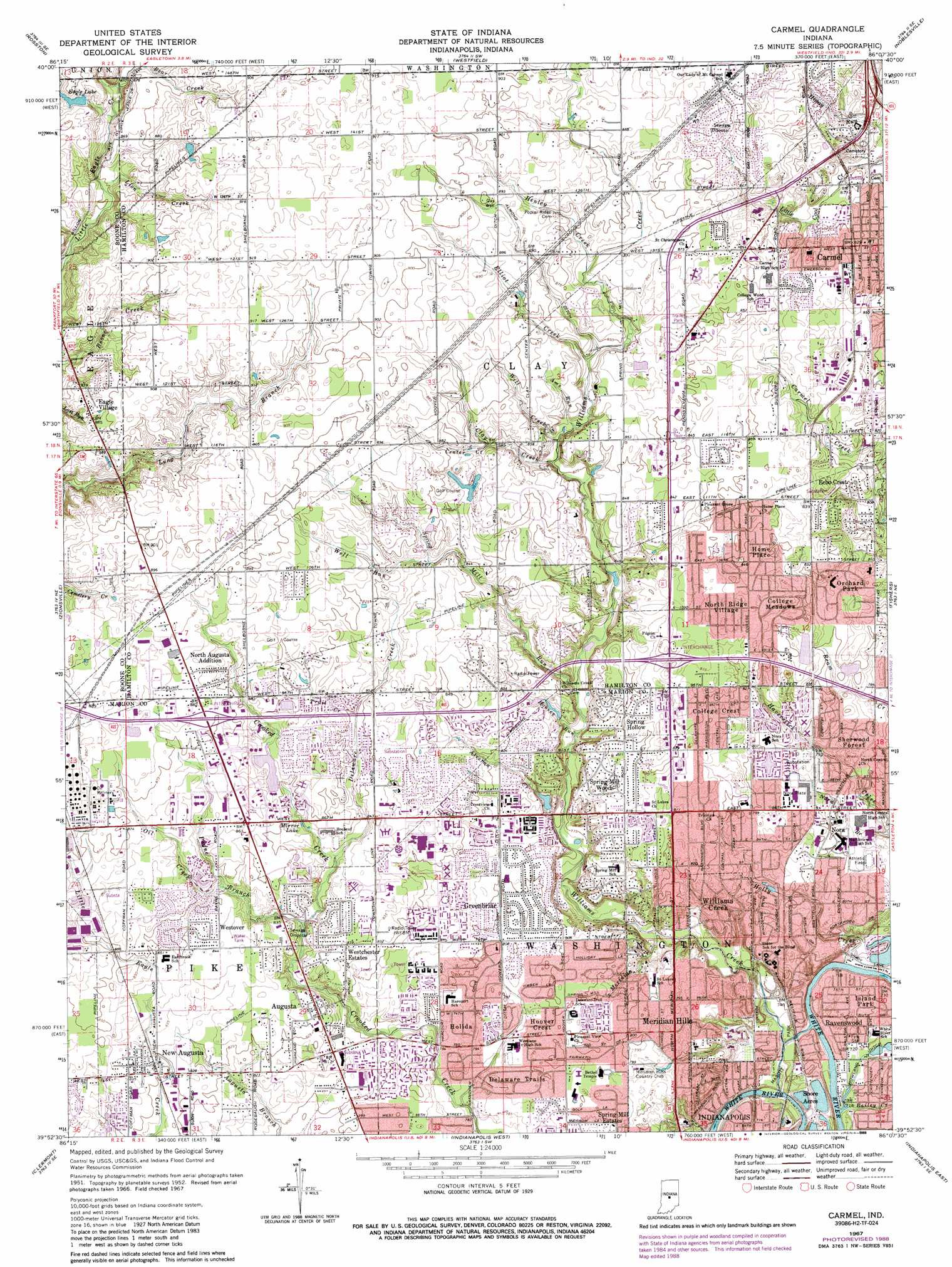
Carmel Topo Map Indiana
To zoom in, hover over the map of Carmel
USGS Topo Quad 39086h2 - 1:24,000 scale
| Topo Map Name: | Carmel |
| USGS Topo Quad ID: | 39086h2 |
| Print Size: | ca. 21 1/4" wide x 27" high |
| Southeast Coordinates: | 39.875° N latitude / 86.125° W longitude |
| Map Center Coordinates: | 39.9375° N latitude / 86.1875° W longitude |
| U.S. State: | IN |
| Filename: | o39086h2.jpg |
| Download Map JPG Image: | Carmel topo map 1:24,000 scale |
| Map Type: | Topographic |
| Topo Series: | 7.5´ |
| Map Scale: | 1:24,000 |
| Source of Map Images: | United States Geological Survey (USGS) |
| Alternate Map Versions: |
Carmel IN 1952, updated 1953 Download PDF Buy paper map Carmel IN 1959, updated 1960 Download PDF Buy paper map Carmel IN 1967, updated 1969 Download PDF Buy paper map Carmel IN 1967, updated 1980 Download PDF Buy paper map Carmel IN 1967, updated 1988 Download PDF Buy paper map Carmel IN 1967, updated 1988 Download PDF Buy paper map Carmel IN 1998, updated 2002 Download PDF Buy paper map Carmel IN 2010 Download PDF Buy paper map Carmel IN 2013 Download PDF Buy paper map Carmel IN 2016 Download PDF Buy paper map |
1:24,000 Topo Quads surrounding Carmel
Mechanicsburg |
Kirklin |
Sheridan |
Arcadia |
Omega |
Lebanon |
Rosston |
Westfield |
Noblesville |
Riverwood |
Fayette |
Zionsville |
Carmel |
Fishers |
Mccordsville |
Brownsburg |
Clermont |
Indianapolis West |
Indianapolis East |
Cumberland |
Plainfield |
Bridgeport |
Maywood |
Beech Grove |
Acton |
> Back to 39086e1 at 1:100,000 scale
> Back to 39086a1 at 1:250,000 scale
> Back to U.S. Topo Maps home
Carmel topo map: Gazetteer
Carmel: Airports
Saint Vincent Hospital Health Care Center Airport elevation 255m 836′Carmel: Canals
Almond Ditch elevation 268m 879′Howard Johnson Ditch elevation 243m 797′
Carmel: Crossings
Interchange 27 elevation 268m 879′Interchange 31 elevation 263m 862′
Carmel: Dams
Eagle Lake Dam elevation 268m 879′Carmel: Lakes
Mirror Lake elevation 256m 839′Carmel: Parks
Carmel Ice Skadium elevation 255m 836′Carmel/Clay Community Soccer Complex elevation 278m 912′
Ipallo Fields Park elevation 243m 797′
Island Park elevation 221m 725′
Marott Park elevation 220m 721′
Meadow Lawn Park elevation 262m 859′
Pleasant Grove Park elevation 258m 846′
Wish Park elevation 244m 800′
Carmel: Populated Places
Augusta elevation 253m 830′Austin Oaks elevation 272m 892′
Bridlebourne elevation 275m 902′
College Crest elevation 251m 823′
College Meadows elevation 254m 833′
Delaware Trails elevation 241m 790′
Eagle Village elevation 273m 895′
Echo Crest elevation 252m 826′
Greenbriar elevation 243m 797′
Holida elevation 241m 790′
Home Place elevation 258m 846′
Hoover Crest elevation 241m 790′
Kings Mill elevation 271m 889′
Kingsborough elevation 273m 895′
Meridian Hills elevation 242m 793′
New Augusta elevation 255m 836′
Nora elevation 239m 784′
North Augusta Addition elevation 270m 885′
North Ridge Village elevation 258m 846′
Orchard Park elevation 250m 820′
Ravenswood elevation 221m 725′
Saddle Creek elevation 273m 895′
Sherwood Forest elevation 238m 780′
Shore Acres elevation 218m 715′
Spring Hollow elevation 252m 826′
Spring Mill Estates elevation 242m 793′
Spring Mill Woods elevation 251m 823′
Westchester Estates elevation 256m 839′
Westover elevation 258m 846′
Williams Creek elevation 236m 774′
Windemere elevation 263m 862′
Carmel: Post Offices
Ravenswood Post Office (historical) elevation 220m 721′Carmel: Reservoirs
Eagle Lake elevation 268m 879′Lake Ullswater elevation 274m 898′
Lake Windemere elevation 273m 895′
Carmel: Streams
Alverna Creek elevation 234m 767′Ams Run elevation 253m 830′
Bailey Creek elevation 220m 721′
Center Creek elevation 258m 846′
Clay Creek elevation 252m 826′
Delaware Creek elevation 252m 826′
Dry Run elevation 220m 721′
Elliot Creek elevation 256m 839′
Henley Creek elevation 261m 856′
Holly Creek elevation 219m 718′
Hoover Run elevation 238m 780′
Lion Creek elevation 260m 853′
Meridian Creek elevation 228m 748′
Oil Creek elevation 255m 836′
Payne Branch elevation 250m 820′
Spring Mill Run elevation 241m 790′
Well Run elevation 259m 849′
Will Creek elevation 253m 830′
Williams Creek elevation 216m 708′
Witt Creek elevation 252m 826′
Carmel digital topo map on disk
Buy this Carmel topo map showing relief, roads, GPS coordinates and other geographical features, as a high-resolution digital map file on DVD:
Northern Illinois, Northern Indiana & Southwestern Michigan
Buy digital topo maps: Northern Illinois, Northern Indiana & Southwestern Michigan