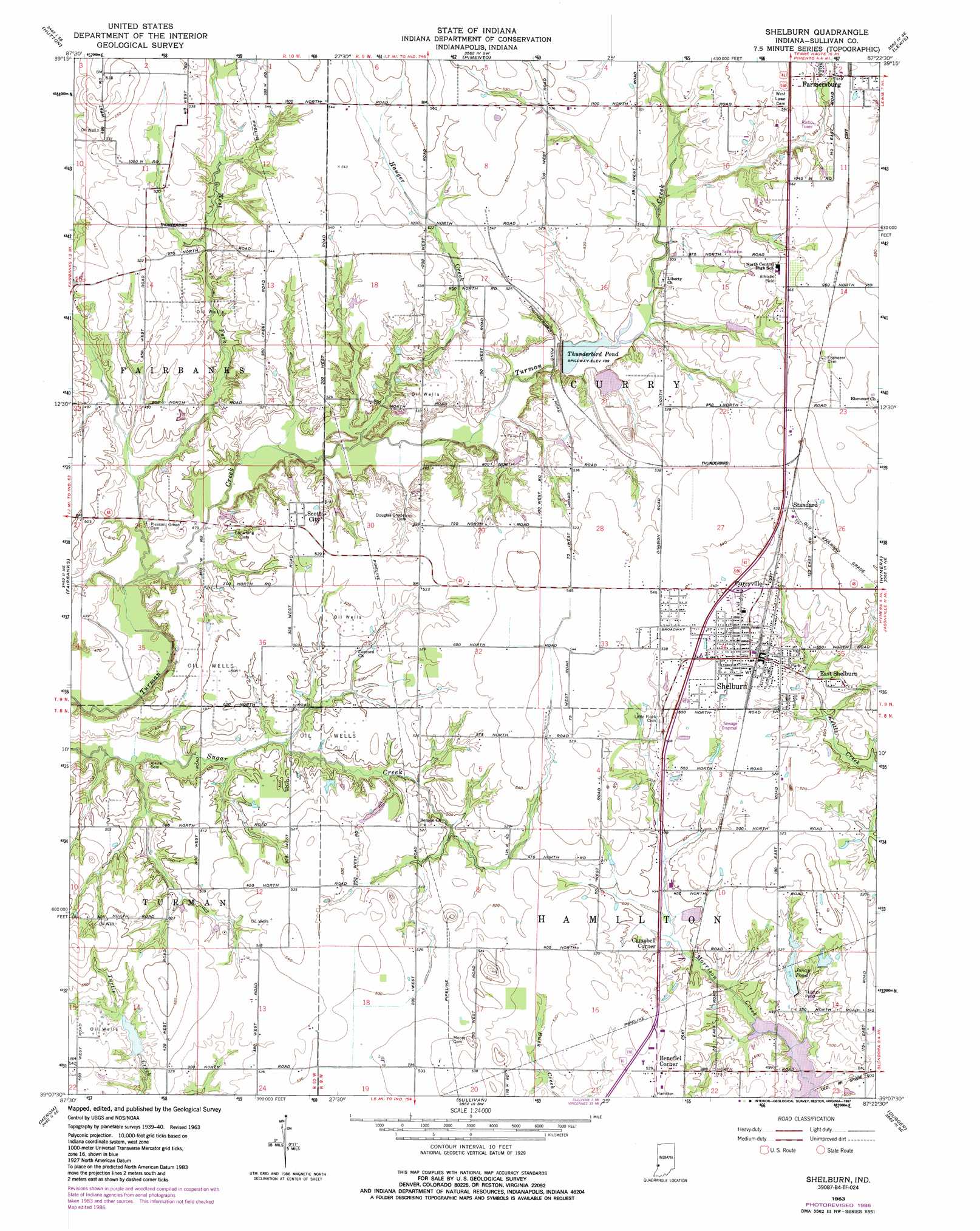
Shelburn Topo Map Indiana
To zoom in, hover over the map of Shelburn
USGS Topo Quad 39087b4 - 1:24,000 scale
| Topo Map Name: | Shelburn |
| USGS Topo Quad ID: | 39087b4 |
| Print Size: | ca. 21 1/4" wide x 27" high |
| Southeast Coordinates: | 39.125° N latitude / 87.375° W longitude |
| Map Center Coordinates: | 39.1875° N latitude / 87.4375° W longitude |
| U.S. State: | IN |
| Filename: | o39087b4.jpg |
| Download Map JPG Image: | Shelburn topo map 1:24,000 scale |
| Map Type: | Topographic |
| Topo Series: | 7.5´ |
| Map Scale: | 1:24,000 |
| Source of Map Images: | United States Geological Survey (USGS) |
| Alternate Map Versions: |
Shelburn IN 1942 Download PDF Buy paper map Shelburn IN 1952, updated 1953 Download PDF Buy paper map Shelburn IN 1963, updated 1964 Download PDF Buy paper map Shelburn IN 1963, updated 1978 Download PDF Buy paper map Shelburn IN 1963, updated 1981 Download PDF Buy paper map Shelburn IN 1963, updated 1987 Download PDF Buy paper map Shelburn IN 2010 Download PDF Buy paper map Shelburn IN 2013 Download PDF Buy paper map Shelburn IN 2016 Download PDF Buy paper map |
1:24,000 Topo Quads surrounding Shelburn
Marshall |
Dennison |
Terre Haute |
Seelyville |
Staunton |
Snyder |
Hutton |
Pimento |
Lewis |
Saline City |
West Union |
Fairbanks |
Shelburn |
Hymera |
Jasonville |
Hutsonville |
Merom |
Sullivan |
Dugger |
Linton |
Flat Rock |
Heathsville |
Carlisle |
Bucktown |
Sandborn |
> Back to 39087a1 at 1:100,000 scale
> Back to 39086a1 at 1:250,000 scale
> Back to U.S. Topo Maps home
Shelburn topo map: Gazetteer
Shelburn: Dams
Jonay Pond Dam elevation 152m 498′Turtle Creek Lake Dam elevation 157m 515′
Shelburn: Flats
Curry Prairie elevation 166m 544′Shelburn: Populated Places
Benefiel Corner elevation 161m 528′Campbell Corner elevation 152m 498′
Curryville elevation 162m 531′
East Shelburn elevation 160m 524′
Farmersburg elevation 172m 564′
Massacre elevation 152m 498′
Scott City elevation 161m 528′
Shelburn elevation 165m 541′
Standard elevation 162m 531′
Shelburn: Reservoirs
Jonay Pond elevation 152m 498′Tailings Pond elevation 150m 492′
Thunderbird Pond elevation 155m 508′
Turtle Creek Lake elevation 157m 515′
Shelburn: Streams
Curry Prairie Creek elevation 155m 508′Hauger Creek elevation 147m 482′
West Fork Turman Creek elevation 143m 469′
Shelburn digital topo map on disk
Buy this Shelburn topo map showing relief, roads, GPS coordinates and other geographical features, as a high-resolution digital map file on DVD:
Northern Illinois, Northern Indiana & Southwestern Michigan
Buy digital topo maps: Northern Illinois, Northern Indiana & Southwestern Michigan