Dennison Topo Map Illinois
To zoom in, hover over the map of Dennison
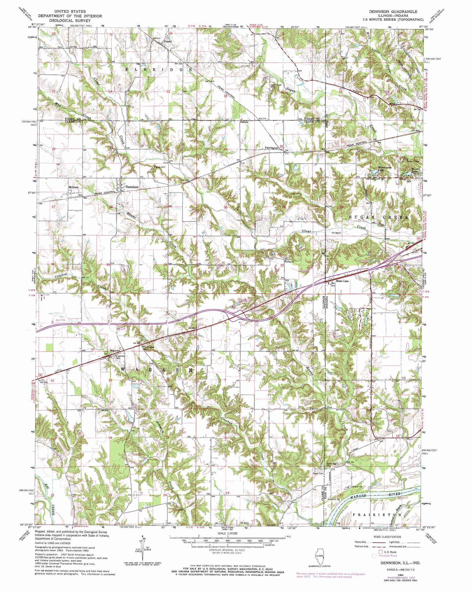
USGS Topo Quad 39087d5 - 1:24,000 scale
| Topo Map Name: | Dennison |
| USGS Topo Quad ID: | 39087d5 |
| Print Size: | ca. 21 1/4" wide x 27" high |
| Southeast Coordinates: | 39.375° N latitude / 87.5° W longitude |
| Map Center Coordinates: | 39.4375° N latitude / 87.5625° W longitude |
| U.S. States: | IL, IN |
| Filename: | o39087d5.jpg |
| Download Map JPG Image: | Dennison topo map 1:24,000 scale |
| Map Type: | Topographic |
| Topo Series: | 7.5´ |
| Map Scale: | 1:24,000 |
| Source of Map Images: | United States Geological Survey (USGS) |
| Alternate Map Versions: |
Dennison IL 1942 Download PDF Buy paper map Dennison IL 1964, updated 1965 Download PDF Buy paper map Dennison IL 1964, updated 1973 Download PDF Buy paper map Dennison IL 1964, updated 1973 Download PDF Buy paper map Dennison IL 1998, updated 2002 Download PDF Buy paper map Dennison IL 2010 Download PDF Buy paper map Dennison IL 2012 Download PDF Buy paper map Dennison IL 2015 Download PDF Buy paper map |
1:24,000 Topo Quads surrounding Dennison
Redmon |
Paris North |
Saint Bernice |
Clinton |
Mecca |
Grandview |
Paris South |
Sandford |
New Goshen |
Rosedale |
Clarksville |
Marshall |
Dennison |
Terre Haute |
Seelyville |
Clark Center |
Snyder |
Hutton |
Pimento |
Lewis |
Annapolis |
West Union |
Fairbanks |
Shelburn |
Hymera |
> Back to 39087a1 at 1:100,000 scale
> Back to 39086a1 at 1:250,000 scale
> Back to U.S. Topo Maps home
Dennison topo map: Gazetteer
Dennison: Crossings
Interchange 154 elevation 171m 561′Dennison: Dams
Illinois No Name Number 2043 Dam elevation 160m 524′Kieweg Lake Dam elevation 157m 515′
Wanda Lake Dam elevation 161m 528′
Windmere Lake Dam elevation 173m 567′
Dennison: Parks
Camp Illana elevation 161m 528′Dennison: Populated Places
Dennison elevation 177m 580′Farrington elevation 176m 577′
Ferrel elevation 186m 610′
McKeen elevation 177m 580′
Patton elevation 177m 580′
State Line elevation 171m 561′
Weaver elevation 171m 561′
Dennison: Post Offices
Dennison Post Office elevation 176m 577′Nelson Post Office (historical) elevation 159m 521′
Dennison: Reservoirs
Illinois No Name Number 2043 Reservoir elevation 160m 524′Kieweg Lake elevation 167m 547′
Wanda Lake elevation 161m 528′
Windemere Lake elevation 162m 531′
Dennison: Streams
Clear Creek elevation 146m 479′Crooked Creek elevation 134m 439′
Crooked Creek elevation 134m 439′
Hawks Creek elevation 136m 446′
Hawks Creek elevation 136m 446′
Mud Creek elevation 161m 528′
Sugar Creek elevation 146m 479′
West Little Sugar Creek elevation 146m 479′
West Little Sugar Creek elevation 146m 479′
Dennison digital topo map on disk
Buy this Dennison topo map showing relief, roads, GPS coordinates and other geographical features, as a high-resolution digital map file on DVD:
Northern Illinois, Northern Indiana & Southwestern Michigan
Buy digital topo maps: Northern Illinois, Northern Indiana & Southwestern Michigan