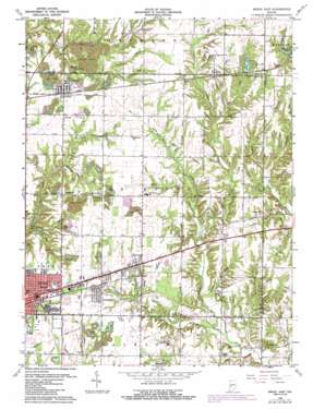
Brazil East Topo Map Indiana
To zoom in, hover over the map of Brazil East
USGS Topo Quad 39087e1 - 1:24,000 scale
| Topo Map Name: | Brazil East |
| USGS Topo Quad ID: | 39087e1 |
| Print Size: | ca. 21 1/4" wide x 27" high |
| Southeast Coordinates: | 39.5° N latitude / 87° W longitude |
| Map Center Coordinates: | 39.5625° N latitude / 87.0625° W longitude |
| U.S. State: | IN |
| Filename: | o39087e1.jpg |
| Download Map JPG Image: | Brazil East topo map 1:24,000 scale |
| Map Type: | Topographic |
| Topo Series: | 7.5´ |
| Map Scale: | 1:24,000 |
| Source of Map Images: | United States Geological Survey (USGS) |
| Alternate Map Versions: |
Brazil East IN 1950, updated 1952 Download PDF Buy paper map Brazil East IN 1960, updated 1960 Download PDF Buy paper map Brazil East IN 1960, updated 1973 Download PDF Buy paper map Brazil East IN 1960, updated 1987 Download PDF Buy paper map Brazil East IN 2010 Download PDF Buy paper map Brazil East IN 2013 Download PDF Buy paper map Brazil East IN 2016 Download PDF Buy paper map |
1:24,000 Topo Quads surrounding Brazil East
> Back to 39087e1 at 1:100,000 scale
> Back to 39086a1 at 1:250,000 scale
> Back to U.S. Topo Maps home
Brazil East topo map: Gazetteer
Brazil East: Dams
Bowles Lake Dam elevation 204m 669′Risslers Lake Dam elevation 197m 646′
Brazil East: Lakes
Alma Lake elevation 212m 695′Thomas Lake elevation 210m 688′
Brazil East: Populated Places
Alma Lake elevation 233m 764′Benwood elevation 205m 672′
Calcutta elevation 222m 728′
Carbon elevation 211m 692′
Cardonia elevation 195m 639′
Donaldsonville elevation 209m 685′
Harmony elevation 201m 659′
Knightsville elevation 204m 669′
Lena elevation 210m 688′
Mechanicsburg elevation 208m 682′
Pontiac elevation 205m 672′
Brazil East: Reservoirs
Bowles Lake elevation 204m 669′Risslers Lake elevation 197m 646′
Brazil East: Streams
Alma Creek elevation 207m 679′Benwood Run elevation 183m 600′
Bethel Run elevation 198m 649′
Billy Creek elevation 183m 600′
Bullet Branch elevation 190m 623′
Calcutta Run elevation 211m 692′
Cardonia Run elevation 202m 662′
Dam Brook elevation 183m 600′
East Brook elevation 195m 639′
Ebenezer Creek elevation 205m 672′
Girton Run elevation 204m 669′
Gun Creek elevation 182m 597′
Harm Run elevation 198m 649′
Harmony Drain elevation 193m 633′
Jack Brook elevation 210m 688′
Kid Run elevation 188m 616′
Lena Drain elevation 205m 672′
National Run elevation 200m 656′
Pell Brook elevation 208m 682′
Poff Brook elevation 198m 649′
Roberts Brook elevation 186m 610′
School Brook elevation 192m 629′
Scrouge Branch elevation 212m 695′
Van Buren Creek elevation 209m 685′
Wesley Drain elevation 183m 600′
Brazil East: Valleys
Green Hollow elevation 203m 666′Brazil East digital topo map on disk
Buy this Brazil East topo map showing relief, roads, GPS coordinates and other geographical features, as a high-resolution digital map file on DVD:
Northern Illinois, Northern Indiana & Southwestern Michigan
Buy digital topo maps: Northern Illinois, Northern Indiana & Southwestern Michigan


