Georgetown Topo Map Illinois
To zoom in, hover over the map of Georgetown
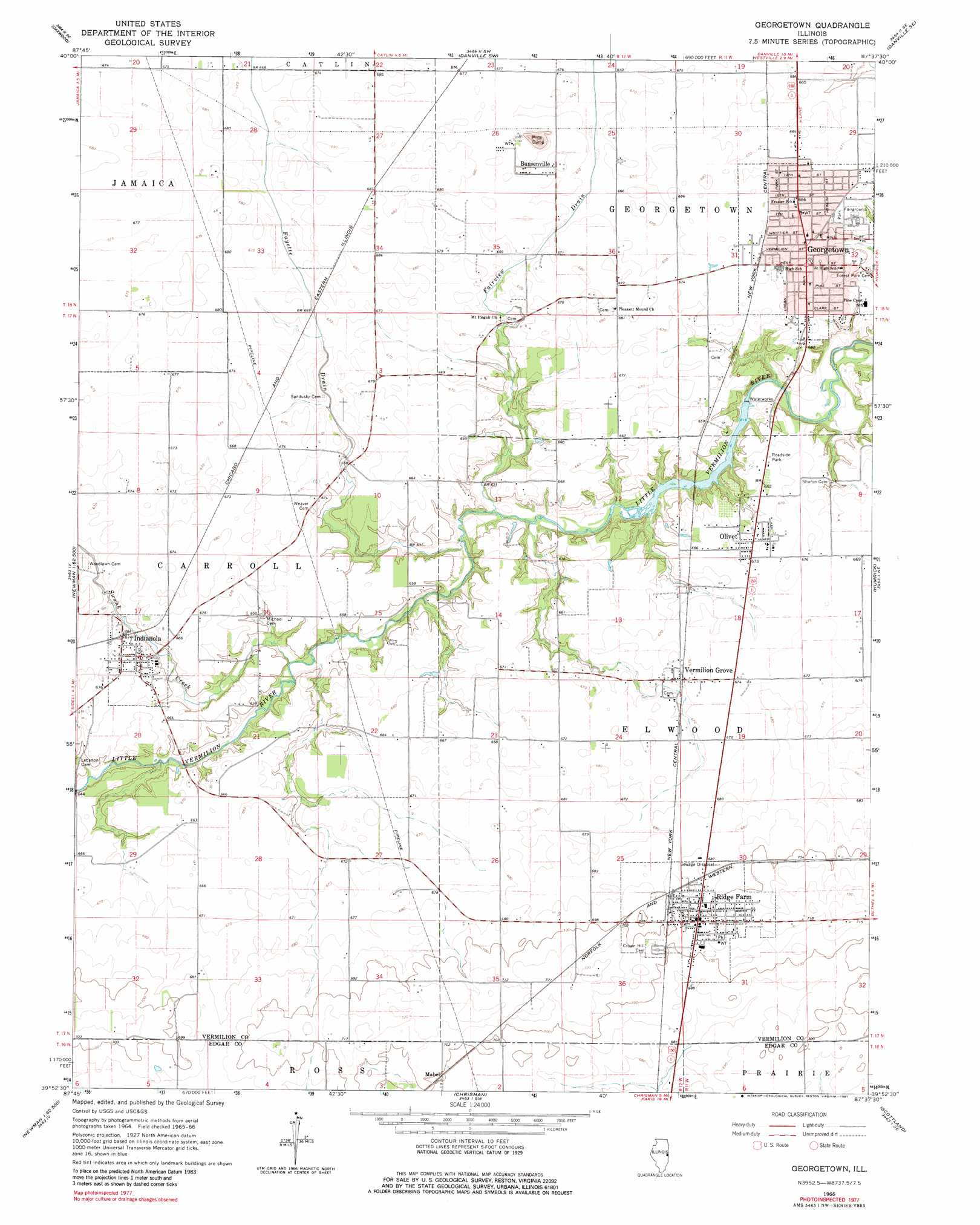
USGS Topo Quad 39087h6 - 1:24,000 scale
| Topo Map Name: | Georgetown |
| USGS Topo Quad ID: | 39087h6 |
| Print Size: | ca. 21 1/4" wide x 27" high |
| Southeast Coordinates: | 39.875° N latitude / 87.625° W longitude |
| Map Center Coordinates: | 39.9375° N latitude / 87.6875° W longitude |
| U.S. State: | IL |
| Filename: | o39087h6.jpg |
| Download Map JPG Image: | Georgetown topo map 1:24,000 scale |
| Map Type: | Topographic |
| Topo Series: | 7.5´ |
| Map Scale: | 1:24,000 |
| Source of Map Images: | United States Geological Survey (USGS) |
| Alternate Map Versions: |
Georgetown IL 1966, updated 1967 Download PDF Buy paper map Georgetown IL 1966, updated 1981 Download PDF Buy paper map Georgetown IL 2012 Download PDF Buy paper map Georgetown IL 2015 Download PDF Buy paper map |
1:24,000 Topo Quads surrounding Georgetown
Royal |
Collison |
Danville Nw |
Danville Ne |
Covington |
Homer |
Oakwood |
Danville Sw |
Danville Se |
Perrysville |
Allerton |
Sidell |
Georgetown |
Humrick |
Newport |
Newman |
Hume |
Chrisman |
Scottland |
Dana |
Brocton |
Redmon |
Paris North |
Saint Bernice |
Clinton |
> Back to 39087e1 at 1:100,000 scale
> Back to 39086a1 at 1:250,000 scale
> Back to U.S. Topo Maps home
Georgetown topo map: Gazetteer
Georgetown: Dams
Georgetown Reservoir Dam elevation 188m 616′Georgetown: Parks
Public Square elevation 204m 669′Georgetown: Populated Places
Busenville elevation 207m 679′Georgetown elevation 204m 669′
Indianola elevation 205m 672′
Mabel elevation 213m 698′
Olivet elevation 203m 666′
Ridge Farm elevation 214m 702′
Vermilion Grove elevation 205m 672′
Georgetown: Post Offices
Georgetown Post Office elevation 203m 666′Georgetown: Reservoirs
Georgetown Reservoir elevation 188m 616′Georgetown: Streams
Fairview Drain elevation 188m 616′Fayette Drain elevation 188m 616′
Swank Creek elevation 190m 623′
Georgetown digital topo map on disk
Buy this Georgetown topo map showing relief, roads, GPS coordinates and other geographical features, as a high-resolution digital map file on DVD:
Northern Illinois, Northern Indiana & Southwestern Michigan
Buy digital topo maps: Northern Illinois, Northern Indiana & Southwestern Michigan