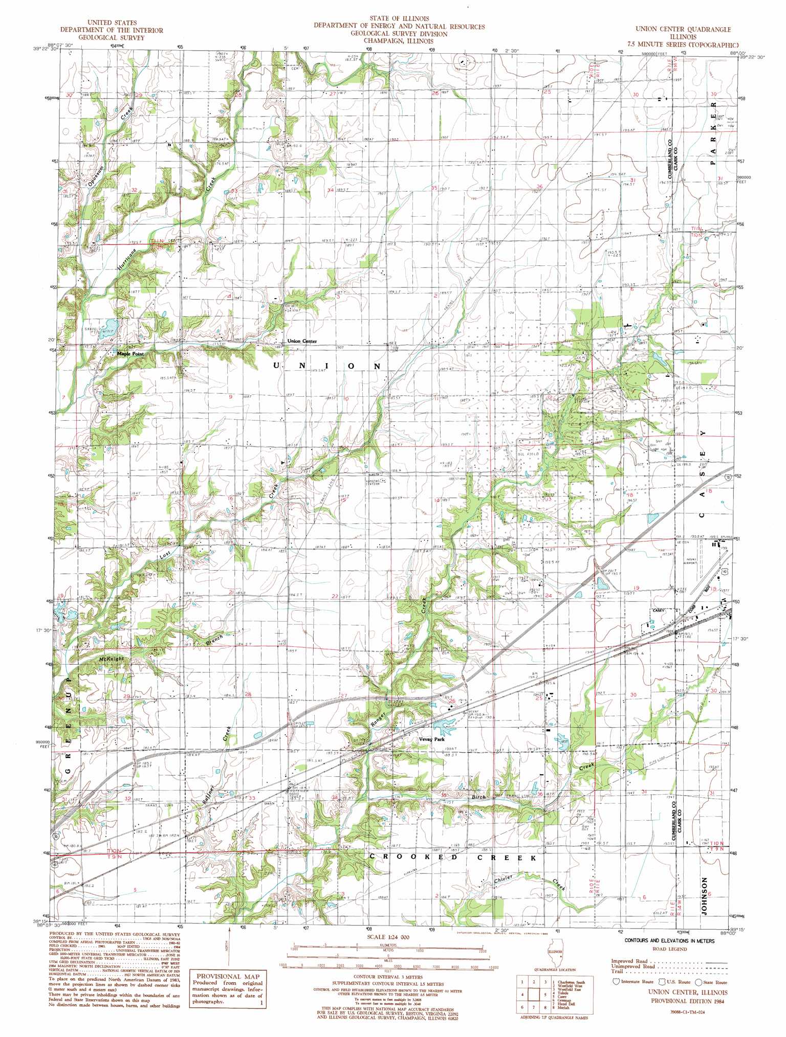
Union Center Topo Map Illinois
To zoom in, hover over the map of Union Center
USGS Topo Quad 39088c1 - 1:24,000 scale
| Topo Map Name: | Union Center |
| USGS Topo Quad ID: | 39088c1 |
| Print Size: | ca. 21 1/4" wide x 27" high |
| Southeast Coordinates: | 39.25° N latitude / 88° W longitude |
| Map Center Coordinates: | 39.3125° N latitude / 88.0625° W longitude |
| U.S. State: | IL |
| Filename: | o39088c1.jpg |
| Download Map JPG Image: | Union Center topo map 1:24,000 scale |
| Map Type: | Topographic |
| Topo Series: | 7.5´ |
| Map Scale: | 1:24,000 |
| Source of Map Images: | United States Geological Survey (USGS) |
| Alternate Map Versions: |
Union Center IL 1984, updated 1985 Download PDF Buy paper map Union Center IL 1998, updated 2003 Download PDF Buy paper map Union Center IL 2012 Download PDF Buy paper map Union Center IL 2015 Download PDF Buy paper map |
1:24,000 Topo Quads surrounding Union Center
Humboldt |
Charleston North |
Ashmore |
Kansas |
Grandview |
Mattoon East |
Charleston South |
Westfield West |
Westfield East |
Clarksville |
Johnstown |
Toledo |
Union Center |
Casey |
Clark Center |
Woodbury |
Greenup |
Hazel Dell |
Moriah |
Annapolis |
Wheeler |
Rose Hill |
Yale |
Oblong North |
Eaton |
> Back to 39088a1 at 1:100,000 scale
> Back to 39088a1 at 1:250,000 scale
> Back to U.S. Topo Maps home
Union Center topo map: Gazetteer
Union Center: Airports
Casey Municipal Airport elevation 199m 652′Union Center: Dams
Ettlebrick Lake Dam elevation 189m 620′Union Center: Populated Places
Maple Point elevation 183m 600′Union Center elevation 188m 616′
Vevay Park elevation 187m 613′
Union Center: Reservoirs
Ettlebrick Lake elevation 189m 620′Union Center: Streams
Birch Creek elevation 172m 564′McKnight Branch elevation 166m 544′
Opossum Creek elevation 171m 561′
Ruffner Creek elevation 169m 554′
Union Center digital topo map on disk
Buy this Union Center topo map showing relief, roads, GPS coordinates and other geographical features, as a high-resolution digital map file on DVD:
Northern Illinois, Northern Indiana & Southwestern Michigan
Buy digital topo maps: Northern Illinois, Northern Indiana & Southwestern Michigan