Charleston South Topo Map Illinois
To zoom in, hover over the map of Charleston South
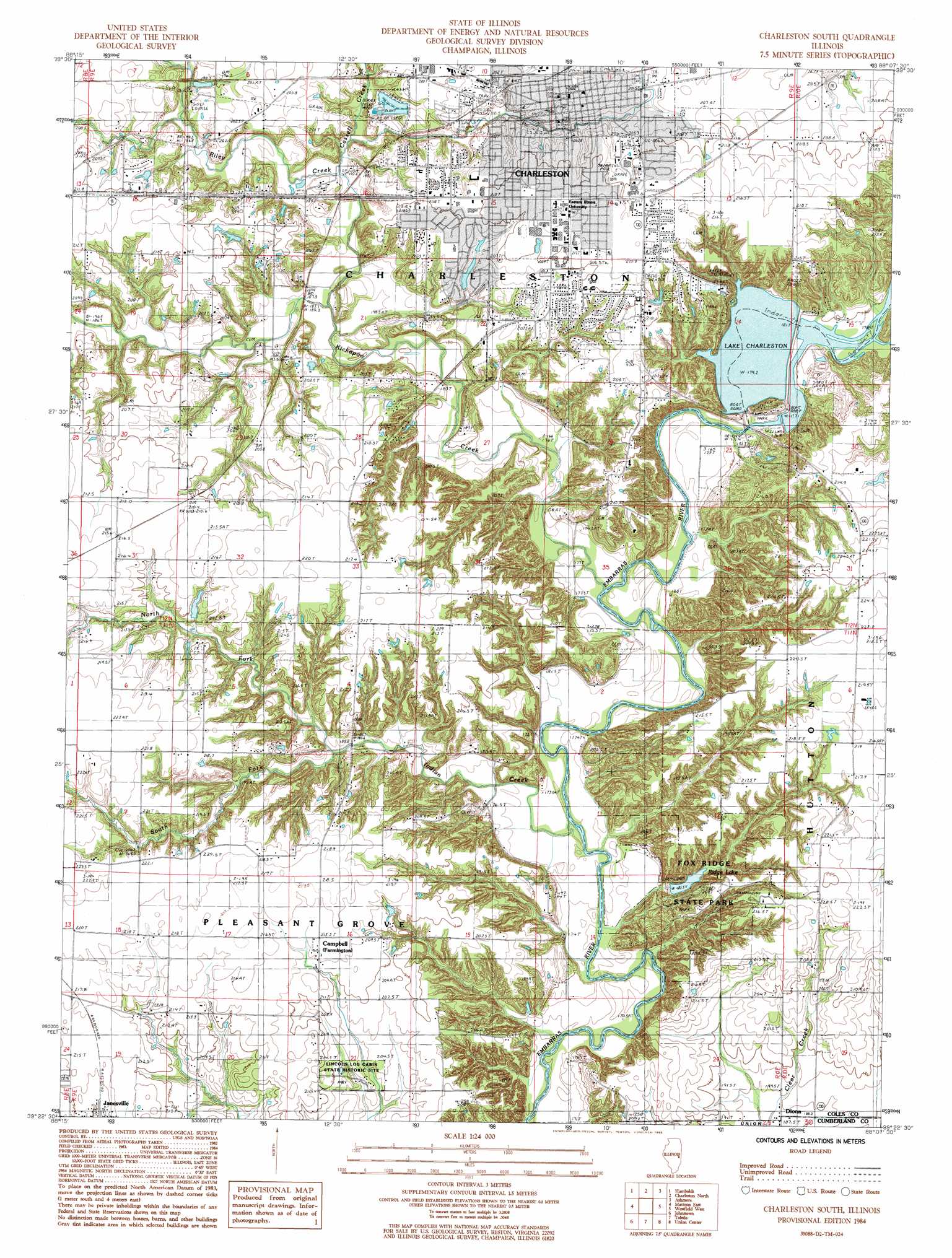
USGS Topo Quad 39088d2 - 1:24,000 scale
| Topo Map Name: | Charleston South |
| USGS Topo Quad ID: | 39088d2 |
| Print Size: | ca. 21 1/4" wide x 27" high |
| Southeast Coordinates: | 39.375° N latitude / 88.125° W longitude |
| Map Center Coordinates: | 39.4375° N latitude / 88.1875° W longitude |
| U.S. State: | IL |
| Filename: | o39088d2.jpg |
| Download Map JPG Image: | Charleston South topo map 1:24,000 scale |
| Map Type: | Topographic |
| Topo Series: | 7.5´ |
| Map Scale: | 1:24,000 |
| Source of Map Images: | United States Geological Survey (USGS) |
| Alternate Map Versions: |
Charleston South IL 1984, updated 1985 Download PDF Buy paper map Charleston South IL 1998, updated 2003 Download PDF Buy paper map Charleston South IL 2012 Download PDF Buy paper map Charleston South IL 2015 Download PDF Buy paper map |
1:24,000 Topo Quads surrounding Charleston South
Arthur |
Arcola |
Hindsburg |
Oakland |
Brocton |
Cooksmill |
Humboldt |
Charleston North |
Ashmore |
Kansas |
Mattoon West |
Mattoon East |
Charleston South |
Westfield West |
Westfield East |
Neoga |
Johnstown |
Toledo |
Union Center |
Casey |
Teutopolis |
Woodbury |
Greenup |
Hazel Dell |
Moriah |
> Back to 39088a1 at 1:100,000 scale
> Back to 39088a1 at 1:250,000 scale
> Back to U.S. Topo Maps home
Charleston South topo map: Gazetteer
Charleston South: Areas
Goosenest Prairie elevation 205m 672′Charleston South: Crossings
Blakemans Ford elevation 177m 580′Halls Ford elevation 178m 583′
Hanley Ford elevation 181m 593′
Walker Ford elevation 171m 561′
Charleston South: Dams
Crabill Pond Dam elevation 214m 702′Fox Ridge Lake Dam elevation 197m 646′
Glenwood Lake Dam elevation 196m 643′
Riverview Dam elevation 195m 639′
Riverview Dam elevation 177m 580′
Charleston South: Parks
Fox Ridge State Park elevation 207m 679′Lincoln Log Cabin State Historic Site elevation 202m 662′
Moore Home Historic Site elevation 214m 702′
O'Brien Field elevation 211m 692′
Charleston South: Populated Places
Campbell elevation 214m 702′Charleston elevation 205m 672′
Diona elevation 188m 616′
Charleston South: Post Offices
Charleston Post Office elevation 205m 672′Charleston South: Reservoirs
Crabill Pond elevation 214m 702′Fox Ridge Lake elevation 197m 646′
Glenwood Lake elevation 196m 643′
Lake Charleston elevation 195m 639′
Ridge Lake elevation 182m 597′
Charleston South: Ridges
Fox Ridge elevation 218m 715′Charleston South: Streams
Cassell Creek elevation 184m 603′Indian Creek elevation 171m 561′
Kickapoo Creek elevation 174m 570′
North Fork Indian Creek elevation 185m 606′
Riley Creek elevation 182m 597′
South Fork Indian Creek elevation 185m 606′
Whetstone Creek elevation 187m 613′
Charleston South digital topo map on disk
Buy this Charleston South topo map showing relief, roads, GPS coordinates and other geographical features, as a high-resolution digital map file on DVD:
Northern Illinois, Northern Indiana & Southwestern Michigan
Buy digital topo maps: Northern Illinois, Northern Indiana & Southwestern Michigan