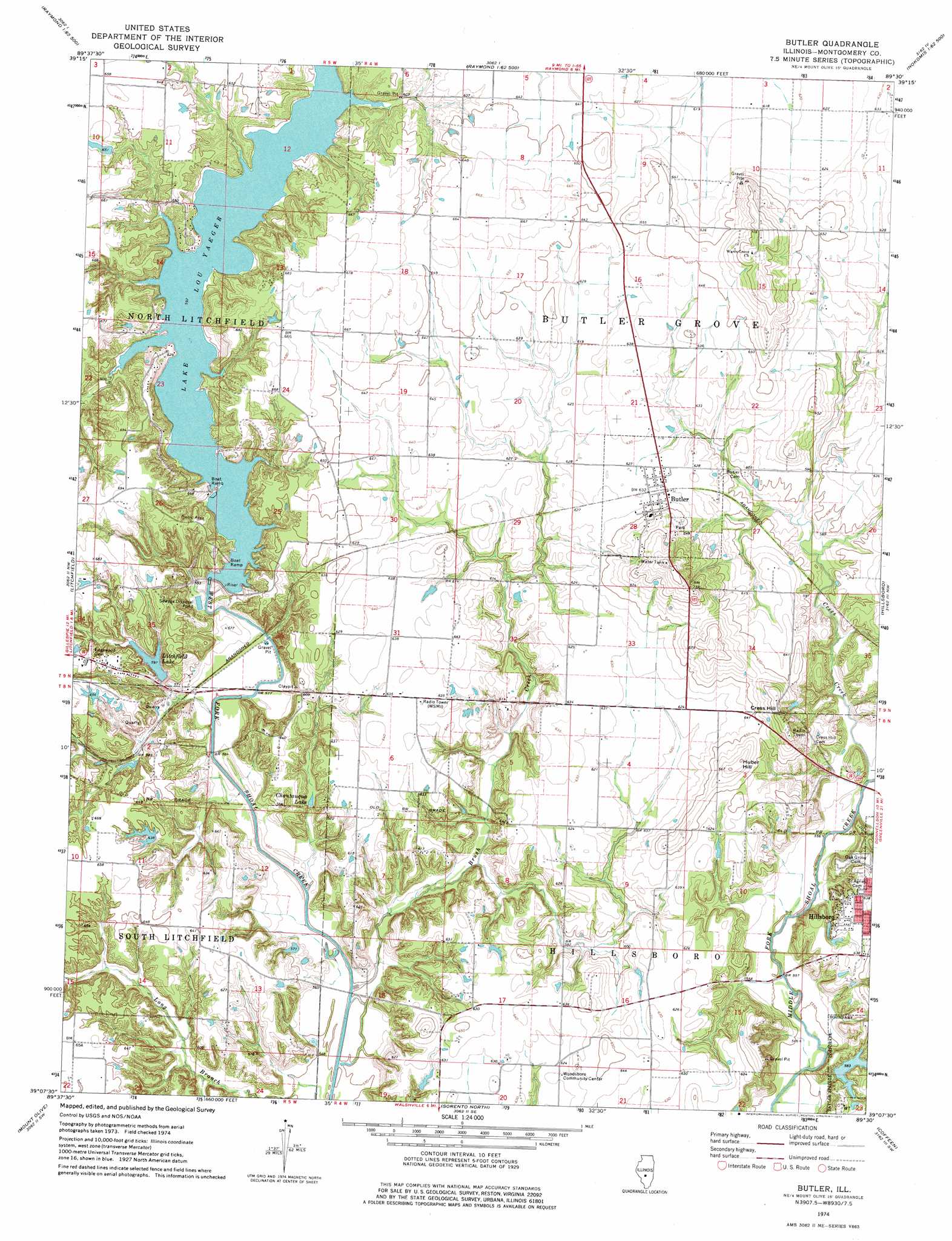
Butler Topo Map Illinois
To zoom in, hover over the map of Butler
USGS Topo Quad 39089b5 - 1:24,000 scale
| Topo Map Name: | Butler |
| USGS Topo Quad ID: | 39089b5 |
| Print Size: | ca. 21 1/4" wide x 27" high |
| Southeast Coordinates: | 39.125° N latitude / 89.5° W longitude |
| Map Center Coordinates: | 39.1875° N latitude / 89.5625° W longitude |
| U.S. State: | IL |
| Filename: | o39089b5.jpg |
| Download Map JPG Image: | Butler topo map 1:24,000 scale |
| Map Type: | Topographic |
| Topo Series: | 7.5´ |
| Map Scale: | 1:24,000 |
| Source of Map Images: | United States Geological Survey (USGS) |
| Alternate Map Versions: |
Butler IL 1974, updated 1977 Download PDF Buy paper map Butler IL 1998, updated 2002 Download PDF Buy paper map Butler IL 2012 Download PDF Buy paper map Butler IL 2015 Download PDF Buy paper map |
1:24,000 Topo Quads surrounding Butler
Virden South |
Farmersville |
Raymond Ne |
Morrisonville |
Clarksdale |
Carlinville East |
Atwater |
Raymond |
Nokomis Sw |
Nokomis |
Gillespie North |
Litchfield |
Butler |
Hillsboro |
Bald Knob |
Gillespie South |
Mount Olive |
Sorento North |
Coffeen |
Fillmore |
Worden |
New Douglas |
Sorento South |
Greenville |
Mulberry Grove |
> Back to 39089a1 at 1:100,000 scale
> Back to 39088a1 at 1:250,000 scale
> Back to U.S. Topo Maps home
Butler topo map: Gazetteer
Butler: Dams
American Zinc Smelter Company Large Lake Dam elevation 178m 583′Lake Lou Yaeger Dam elevation 180m 590′
Litchfield City Lake Dam elevation 182m 597′
Wayne Helen Lake Dam elevation 189m 620′
Butler: Parks
Shoal Creek Nature Conservation Area elevation 192m 629′Butler: Populated Places
Butler elevation 193m 633′Island View elevation 208m 682′
Stagecoach Junction elevation 189m 620′
Sunrise Hills elevation 193m 633′
Butler: Reservoirs
American Zinc Smelter Company Large Lake elevation 178m 583′Chautauqua Lake elevation 175m 574′
Lake Lou Yaeger elevation 180m 590′
Litchfield Lake elevation 182m 597′
Wayne Helen Lake elevation 189m 620′
Butler: Streams
Brush Creek elevation 165m 541′Cress Creek elevation 168m 551′
Butler: Summits
Cress Hill elevation 217m 711′Huber Hill elevation 213m 698′
Butler digital topo map on disk
Buy this Butler topo map showing relief, roads, GPS coordinates and other geographical features, as a high-resolution digital map file on DVD:
Northern Illinois, Northern Indiana & Southwestern Michigan
Buy digital topo maps: Northern Illinois, Northern Indiana & Southwestern Michigan