Virden North Topo Map Illinois
To zoom in, hover over the map of Virden North
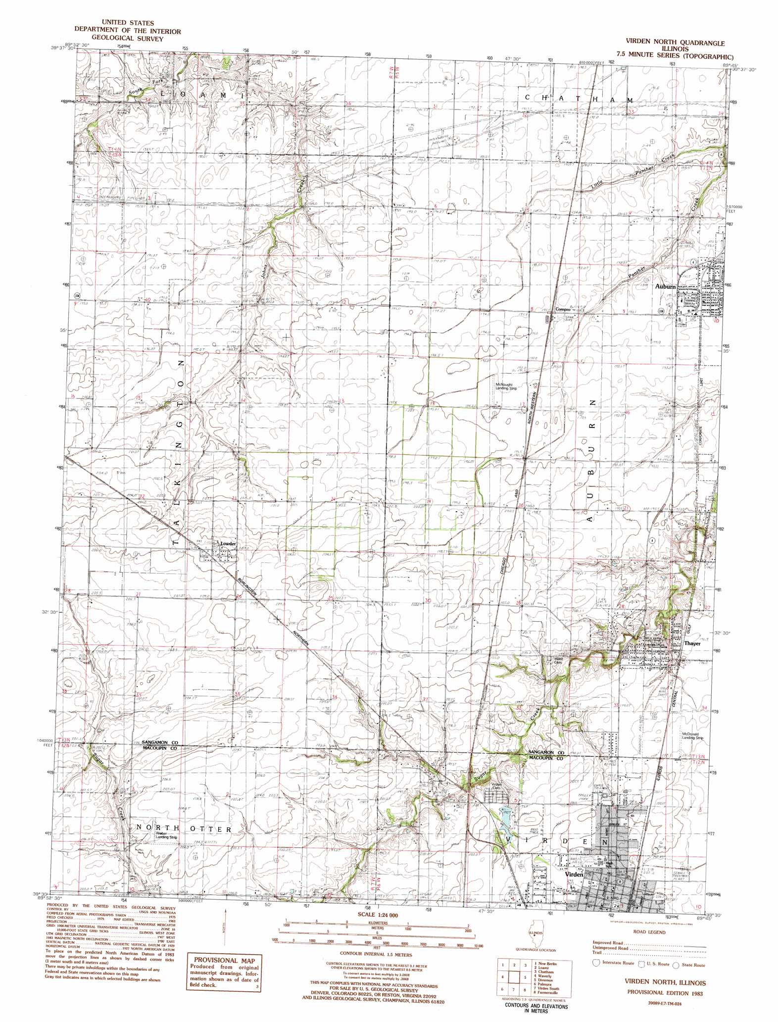
USGS Topo Quad 39089e7 - 1:24,000 scale
| Topo Map Name: | Virden North |
| USGS Topo Quad ID: | 39089e7 |
| Print Size: | ca. 21 1/4" wide x 27" high |
| Southeast Coordinates: | 39.5° N latitude / 89.75° W longitude |
| Map Center Coordinates: | 39.5625° N latitude / 89.8125° W longitude |
| U.S. State: | IL |
| Filename: | o39089e7.jpg |
| Download Map JPG Image: | Virden North topo map 1:24,000 scale |
| Map Type: | Topographic |
| Topo Series: | 7.5´ |
| Map Scale: | 1:24,000 |
| Source of Map Images: | United States Geological Survey (USGS) |
| Alternate Map Versions: |
Virden North IL 1983, updated 1983 Download PDF Buy paper map Virden North IL 1998, updated 2002 Download PDF Buy paper map Virden North IL 2012 Download PDF Buy paper map Virden North IL 2015 Download PDF Buy paper map |
1:24,000 Topo Quads surrounding Virden North
Prentice |
Pleasant Plains |
Farmingdale |
Springfield West |
Springfield East |
Alexander |
New Berlin |
Loami |
Chatham |
New City |
Franklin |
Waverly |
Virden North |
Divernon |
Pawnee |
Scottville |
Palmyra |
Virden South |
Farmersville |
Raymond Ne |
Hettick |
Carlinville West |
Carlinville East |
Atwater |
Raymond |
> Back to 39089e1 at 1:100,000 scale
> Back to 39088a1 at 1:250,000 scale
> Back to U.S. Topo Maps home
Virden North topo map: Gazetteer
Virden North: Airports
McDonald Landing Strip elevation 200m 656′McNaught Landing Strip elevation 194m 636′
Weber Field elevation 204m 669′
Virden North: Dams
Virden Recreation Club Lake Dam elevation 199m 652′Virden North: Populated Places
Compro elevation 195m 639′Lemmon (historical) elevation 203m 666′
Lowder elevation 211m 692′
Thayer elevation 196m 643′
Tower Heights elevation 198m 649′
Virden elevation 206m 675′
Virden North: Post Offices
Virden Post Office elevation 207m 679′Virden North: Reservoirs
Virden Recreation Club Lake elevation 199m 652′Virden North: Streams
Little Panther Creek elevation 186m 610′Virden North digital topo map on disk
Buy this Virden North topo map showing relief, roads, GPS coordinates and other geographical features, as a high-resolution digital map file on DVD:
Northern Illinois, Northern Indiana & Southwestern Michigan
Buy digital topo maps: Northern Illinois, Northern Indiana & Southwestern Michigan