Truxton Topo Map Missouri
To zoom in, hover over the map of Truxton
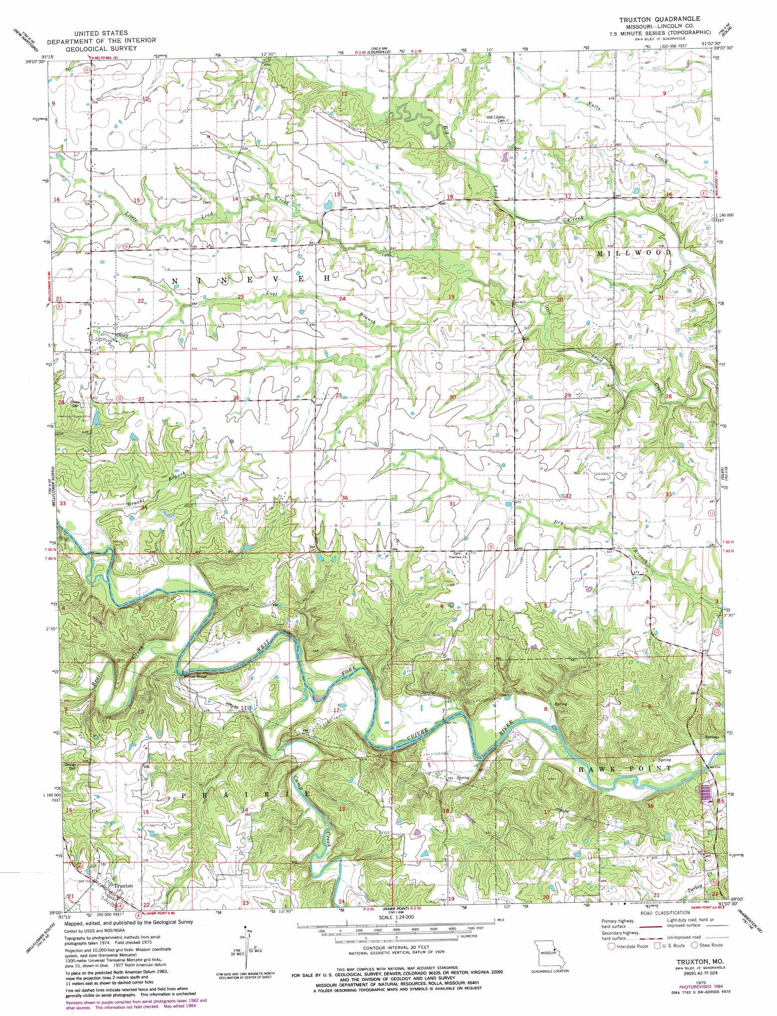
USGS Topo Quad 39091a2 - 1:24,000 scale
| Topo Map Name: | Truxton |
| USGS Topo Quad ID: | 39091a2 |
| Print Size: | ca. 21 1/4" wide x 27" high |
| Southeast Coordinates: | 39° N latitude / 91.125° W longitude |
| Map Center Coordinates: | 39.0625° N latitude / 91.1875° W longitude |
| U.S. State: | MO |
| Filename: | o39091a2.jpg |
| Download Map JPG Image: | Truxton topo map 1:24,000 scale |
| Map Type: | Topographic |
| Topo Series: | 7.5´ |
| Map Scale: | 1:24,000 |
| Source of Map Images: | United States Geological Survey (USGS) |
| Alternate Map Versions: |
Truxton MO 1975, updated 1977 Download PDF Buy paper map Truxton MO 1975, updated 1984 Download PDF Buy paper map Truxton MO 2012 Download PDF Buy paper map Truxton MO 2014 Download PDF Buy paper map |
1:24,000 Topo Quads surrounding Truxton
Vandalia |
Curryville |
Bowling Green |
Cyrene |
Clarksville |
Middletown |
New Hartford |
Louisville |
Eolia |
Auburn |
Buell |
Bellflower North |
Truxton |
Silex |
Okete |
New Florence |
Bellflower South |
Hawk Point |
Warrenton Ne |
Troy |
Pinnacle Lake |
Jonesburg |
Warrenton |
Wright City |
Foristell |
> Back to 39091a1 at 1:100,000 scale
> Back to 39090a1 at 1:250,000 scale
> Back to U.S. Topo Maps home
Truxton topo map: Gazetteer
Truxton: Bridges
Millsap Bridge elevation 163m 534′Truxton: Dams
Welshmeyer Lake Dam elevation 193m 633′Truxton: Populated Places
Fairview elevation 202m 662′Olney elevation 216m 708′
Truxton elevation 224m 734′
Truxton: Post Offices
Fairview Post Office (historical) elevation 202m 662′Truxton: Streams
Bear Creek elevation 164m 538′Bracht Branch elevation 169m 554′
Camp Creek elevation 165m 541′
Lost Branch elevation 189m 620′
Truxton: Valleys
Starkey Hollow elevation 157m 515′Truxton digital topo map on disk
Buy this Truxton topo map showing relief, roads, GPS coordinates and other geographical features, as a high-resolution digital map file on DVD: