Hannibal West Topo Map Missouri
To zoom in, hover over the map of Hannibal West
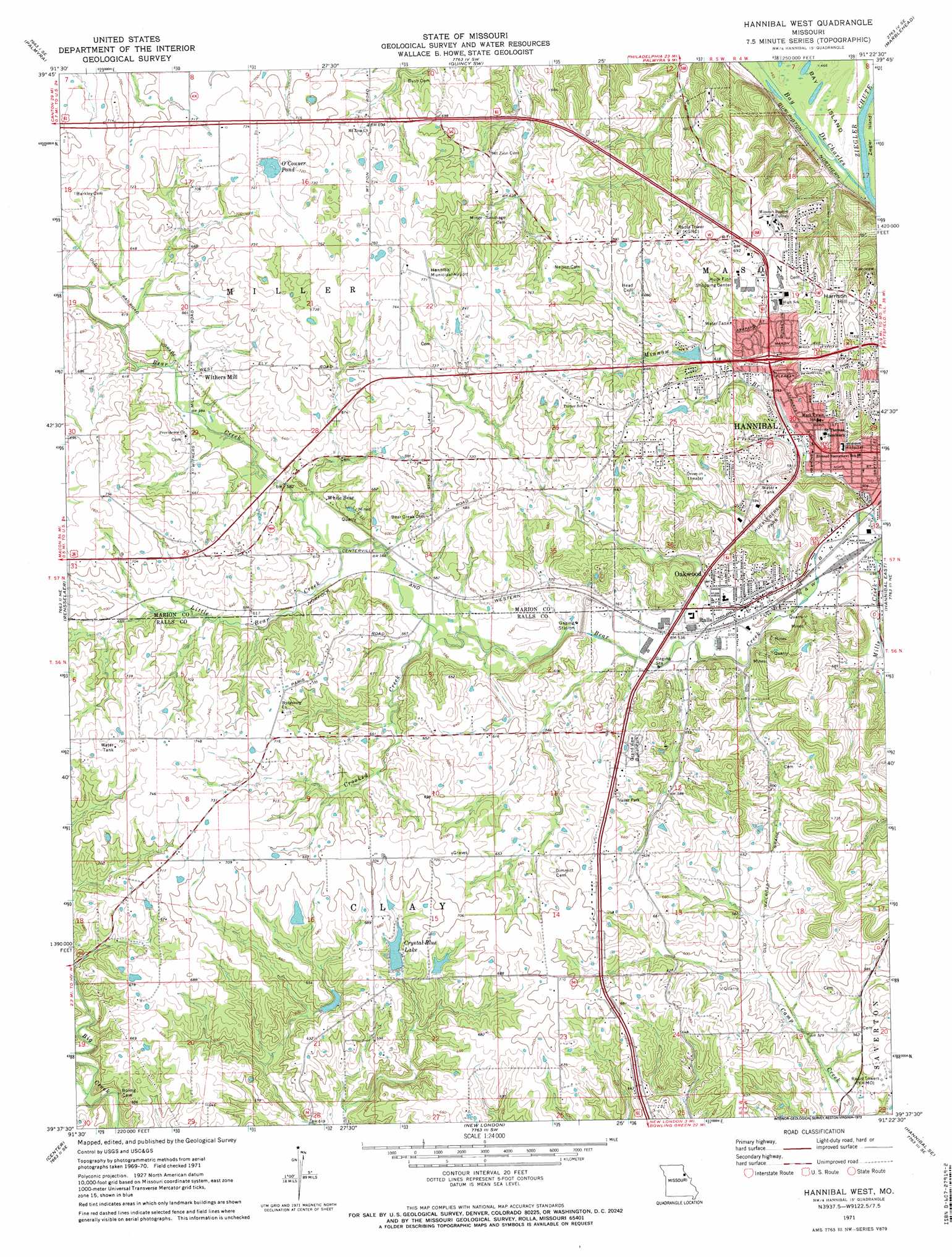
USGS Topo Quad 39091f4 - 1:24,000 scale
| Topo Map Name: | Hannibal West |
| USGS Topo Quad ID: | 39091f4 |
| Print Size: | ca. 21 1/4" wide x 27" high |
| Southeast Coordinates: | 39.625° N latitude / 91.375° W longitude |
| Map Center Coordinates: | 39.6875° N latitude / 91.4375° W longitude |
| U.S. State: | MO |
| Filename: | o39091f4.jpg |
| Download Map JPG Image: | Hannibal West topo map 1:24,000 scale |
| Map Type: | Topographic |
| Topo Series: | 7.5´ |
| Map Scale: | 1:24,000 |
| Source of Map Images: | United States Geological Survey (USGS) |
| Alternate Map Versions: |
Hannibal West MO 1971, updated 1973 Download PDF Buy paper map Hannibal West MO 1971, updated 1973 Download PDF Buy paper map Hannibal West MO 2012 Download PDF Buy paper map Hannibal West MO 2014 Download PDF Buy paper map |
1:24,000 Topo Quads surrounding Hannibal West
Durham |
Maywood |
Quincy West |
Quincy East |
Columbus |
Philadelphia |
Palmyra |
Quincy Sw |
Marblehead |
Payson |
Monroe City |
Rensselaer |
Hannibal West |
Hannibal East |
Hull |
Joanna |
Center |
New London |
Hannibal Se |
Ashburn |
Perry |
Perry Ne |
Spencerburg |
Frankford |
Vera |
> Back to 39091e1 at 1:100,000 scale
> Back to 39090a1 at 1:250,000 scale
> Back to U.S. Topo Maps home
Hannibal West topo map: Gazetteer
Hannibal West: Airports
Hannibal Municipal Airport elevation 234m 767′Mark Twain Landing Field elevation 220m 721′
Hannibal West: Dams
Bear Creek Dam elevation 173m 567′Bowman Dam elevation 183m 600′
Crystal Blue Lake Dam elevation 194m 636′
Jaynes Dam elevation 205m 672′
McKay Dam elevation 185m 606′
Woollen Lake Dam elevation 200m 656′
Hannibal West: Guts
Bay De Charles elevation 143m 469′Hannibal West: Lakes
O'Conner Pond elevation 218m 715′Hannibal West: Parks
Huckleberry Park elevation 181m 593′Hannibal West: Populated Places
Lamb elevation 143m 469′Mount Zion Community elevation 211m 692′
Oakwood elevation 159m 521′
Ralls elevation 162m 531′
Uva elevation 226m 741′
White Bear elevation 178m 583′
Withers Mill elevation 188m 616′
Hannibal West: Reservoirs
Bear Creek Reservoir elevation 173m 567′Bowmans Lake elevation 183m 600′
Charles Ransdell Lake elevation 205m 672′
Charles Ransdell Lake elevation 200m 656′
Crystal Blue Lake elevation 194m 636′
McKay Lake elevation 185m 606′
Hannibal West: Streams
Crooked Creek elevation 168m 551′Daultons Branch elevation 150m 492′
Little Bear Creek elevation 173m 567′
Mills Creek elevation 146m 479′
Minnow Branch elevation 146m 479′
Ziegler Chute elevation 151m 495′
Hannibal West: Summits
College Heights elevation 208m 682′Harrison Hill elevation 222m 728′
Hannibal West: Valleys
Rickey Hollow elevation 171m 561′Hannibal West digital topo map on disk
Buy this Hannibal West topo map showing relief, roads, GPS coordinates and other geographical features, as a high-resolution digital map file on DVD: