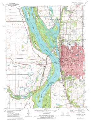
Quincy West Topo Map Illinois
To zoom in, hover over the map of Quincy West
USGS Topo Quad 39091h4 - 1:24,000 scale
| Topo Map Name: | Quincy West |
| USGS Topo Quad ID: | 39091h4 |
| Print Size: | ca. 21 1/4" wide x 27" high |
| Southeast Coordinates: | 39.875° N latitude / 91.375° W longitude |
| Map Center Coordinates: | 39.9375° N latitude / 91.4375° W longitude |
| U.S. States: | IL, MO |
| Filename: | o39091h4.jpg |
| Download Map JPG Image: | Quincy West topo map 1:24,000 scale |
| Map Type: | Topographic |
| Topo Series: | 7.5´ |
| Map Scale: | 1:24,000 |
| Source of Map Images: | United States Geological Survey (USGS) |
| Alternate Map Versions: |
Quincy West IL 1971, updated 1973 Download PDF Buy paper map Quincy West IL 1996, updated 1997 Download PDF Buy paper map Quincy West IL 2012 Download PDF Buy paper map Quincy West IL 2015 Download PDF Buy paper map |
1:24,000 Topo Quads surrounding Quincy West
> Back to 39091e1 at 1:100,000 scale
> Back to 39090a1 at 1:250,000 scale
> Back to U.S. Topo Maps home
Quincy West topo map: Gazetteer
Quincy West: Airports
Blessing Hospital Heliport elevation 189m 620′Saint Mary Hospital Emergency Heliport elevation 177m 580′
Quincy West: Bays
Quincy Bay elevation 145m 475′Quincy West: Bridges
Bay View Bridge elevation 145m 475′Quincy Memorial Bridge elevation 145m 475′
Quincy Memorial Bridge elevation 145m 475′
Quincy West: Dams
Lock and Dam Number 21 elevation 143m 469′Lock and Dam Number Twenty-one elevation 152m 498′
Quincy West: Falls
Homan Falls elevation 158m 518′Quincy West: Flats
Alstynes Prairie elevation 189m 620′Quincy West: Guts
Crooked Slough elevation 142m 465′Quincy West: Islands
Cottonwood Island elevation 145m 475′Deadman Island elevation 146m 479′
Hogback Island elevation 146m 479′
Orton Island elevation 144m 472′
Poage Island elevation 144m 472′
Quinsippi Island elevation 145m 475′
Teal Island elevation 145m 475′
Ward Island elevation 144m 472′
Willow Island elevation 145m 475′
Quincy West: Lakes
Goose Lake elevation 142m 465′Shanty Bend Pond elevation 142m 465′
Spring Lake elevation 157m 515′
Quincy West: Mines
Menke Quarry elevation 148m 485′Quincy West: Parks
All America City Park elevation 152m 498′Berrian Park elevation 178m 583′
Bicentennial Park elevation 147m 482′
Canton Chute Public Use Area elevation 146m 479′
Downtown Quincy Historic District elevation 183m 600′
Edgewater Park elevation 145m 475′
Indian Mounds Park elevation 171m 561′
Johnson Park elevation 185m 606′
Lenane Park elevation 153m 501′
Madison Park elevation 196m 643′
Mark Twain Wildlife Refuge elevation 144m 472′
Parker Heights Park elevation 175m 574′
Quincy East End Historic District elevation 195m 639′
Reservoir Park elevation 205m 672′
Riverview Park elevation 176m 577′
Sid Simpson State Park elevation 145m 475′
South Park elevation 177m 580′
Sunset Park elevation 173m 567′
Villa Katherine Park elevation 178m 583′
Washington Park elevation 183m 600′
Quincy West: Populated Places
Calftown (historical) elevation 179m 587′Cherry Lane Estates elevation 178m 583′
Dunsford elevation 142m 465′
Grandview Acres elevation 189m 620′
Mark elevation 143m 469′
Melrose elevation 185m 606′
North Quincy elevation 183m 600′
Northbrook elevation 184m 603′
Northridge elevation 177m 580′
Palm Garden Mobile Home Park elevation 175m 574′
Quincy elevation 173m 567′
Sheridan Estates elevation 184m 603′
South Crest elevation 189m 620′
South Park Terrace elevation 171m 561′
Southern View elevation 184m 603′
Sunnybrook Meadows elevation 177m 580′
West Quincy elevation 143m 469′
Quincy West: Post Offices
Quincy Post Office elevation 184m 603′Quincy West: Streams
Bear Creek elevation 141m 462′Cedar Creek elevation 143m 469′
Cottonwood Chute elevation 143m 469′
Curtis Creek elevation 143m 469′
Durgens Creek elevation 144m 472′
Fabius River elevation 143m 469′
Frazier Creek elevation 145m 475′
Homan Creek elevation 145m 475′
Old Channel North Fabius River elevation 143m 469′
Quincy West: Valleys
Ghost Hollow elevation 147m 482′Quincy West digital topo map on disk
Buy this Quincy West topo map showing relief, roads, GPS coordinates and other geographical features, as a high-resolution digital map file on DVD:


