Hilldale Topo Map Missouri
To zoom in, hover over the map of Hilldale
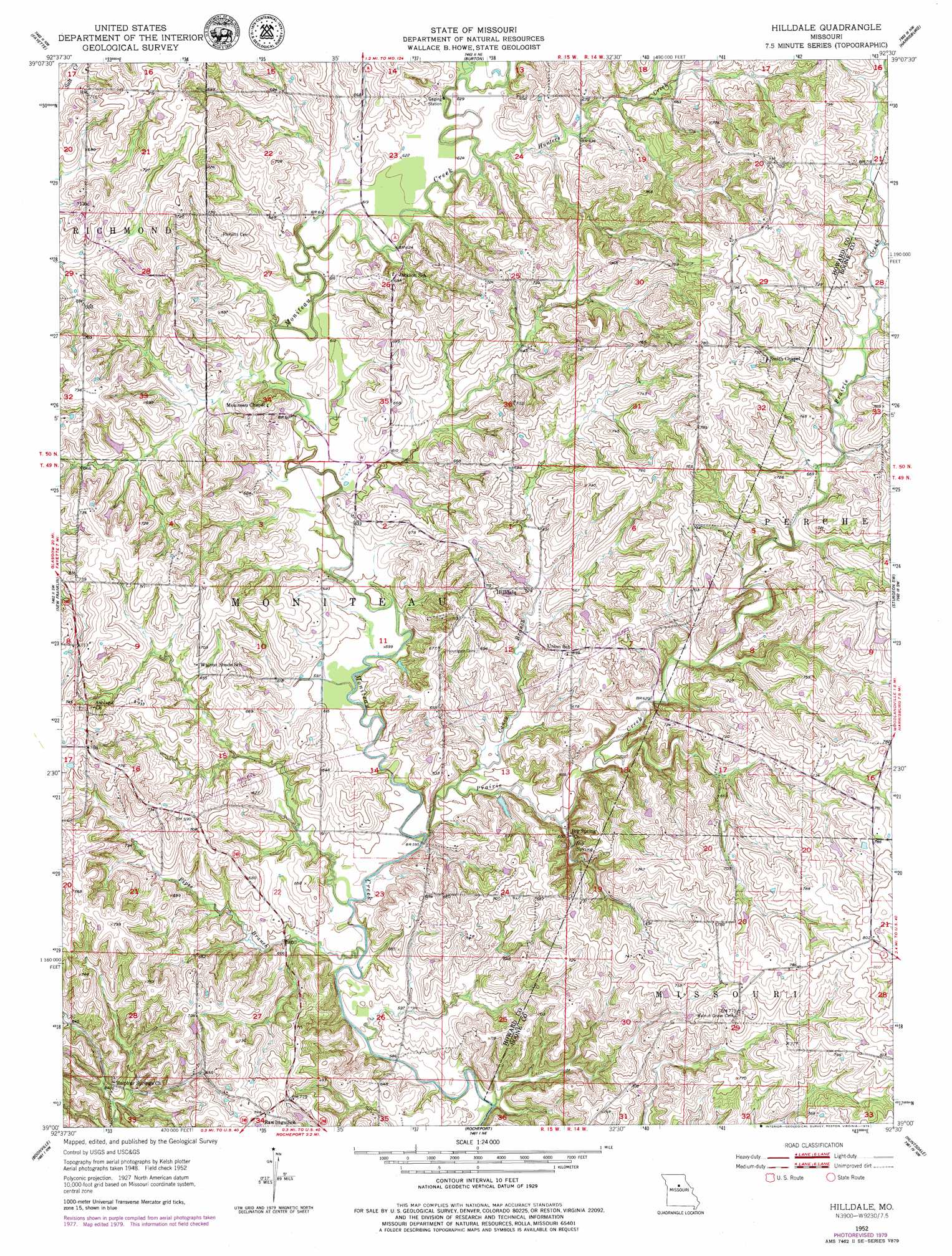
USGS Topo Quad 39092a5 - 1:24,000 scale
| Topo Map Name: | Hilldale |
| USGS Topo Quad ID: | 39092a5 |
| Print Size: | ca. 21 1/4" wide x 27" high |
| Southeast Coordinates: | 39° N latitude / 92.5° W longitude |
| Map Center Coordinates: | 39.0625° N latitude / 92.5625° W longitude |
| U.S. State: | MO |
| Filename: | o39092a5.jpg |
| Download Map JPG Image: | Hilldale topo map 1:24,000 scale |
| Map Type: | Topographic |
| Topo Series: | 7.5´ |
| Map Scale: | 1:24,000 |
| Source of Map Images: | United States Geological Survey (USGS) |
| Alternate Map Versions: |
Hilldale MO 1952, updated 1953 Download PDF Buy paper map Hilldale MO 1952, updated 1979 Download PDF Buy paper map Hilldale MO 2012 Download PDF Buy paper map Hilldale MO 2014 Download PDF Buy paper map |
1:24,000 Topo Quads surrounding Hilldale
Forest Green |
Armstrong |
Higbee |
Renick |
Clark |
Glasgow |
Fayette |
Burton |
Harrisburg |
Sturgeon |
Franklin |
New Franklin |
Hilldale |
Sturgeon Sw |
Browns |
Billingsville |
Boonville |
Rocheport |
Huntsdale |
Columbia |
Bunceton |
Lone Elm |
Prairie Home |
Jamestown |
Ashland |
> Back to 39092a1 at 1:100,000 scale
> Back to 39092a1 at 1:250,000 scale
> Back to U.S. Topo Maps home
Hilldale topo map: Gazetteer
Hilldale: Dams
Petersen Lake Dam elevation 199m 652′Wies Lake Dam elevation 188m 616′
Hilldale: Lakes
Shallow Lake (historical) elevation 180m 590′Hilldale: Populated Places
Hilldale elevation 219m 718′Landmark (historical) elevation 238m 780′
Thralls Prairie (historical) elevation 215m 705′
Wilhite (historical) elevation 230m 754′
Hilldale: Springs
Big Spring elevation 185m 606′U.S. Salt Springs elevation 199m 652′
Hilldale: Streams
Caney Branch elevation 180m 590′Hungry Mother Creek elevation 189m 620′
Hunters Creek elevation 186m 610′
Pipes Branch elevation 177m 580′
Prairie Creek elevation 178m 583′
Hilldale digital topo map on disk
Buy this Hilldale topo map showing relief, roads, GPS coordinates and other geographical features, as a high-resolution digital map file on DVD: