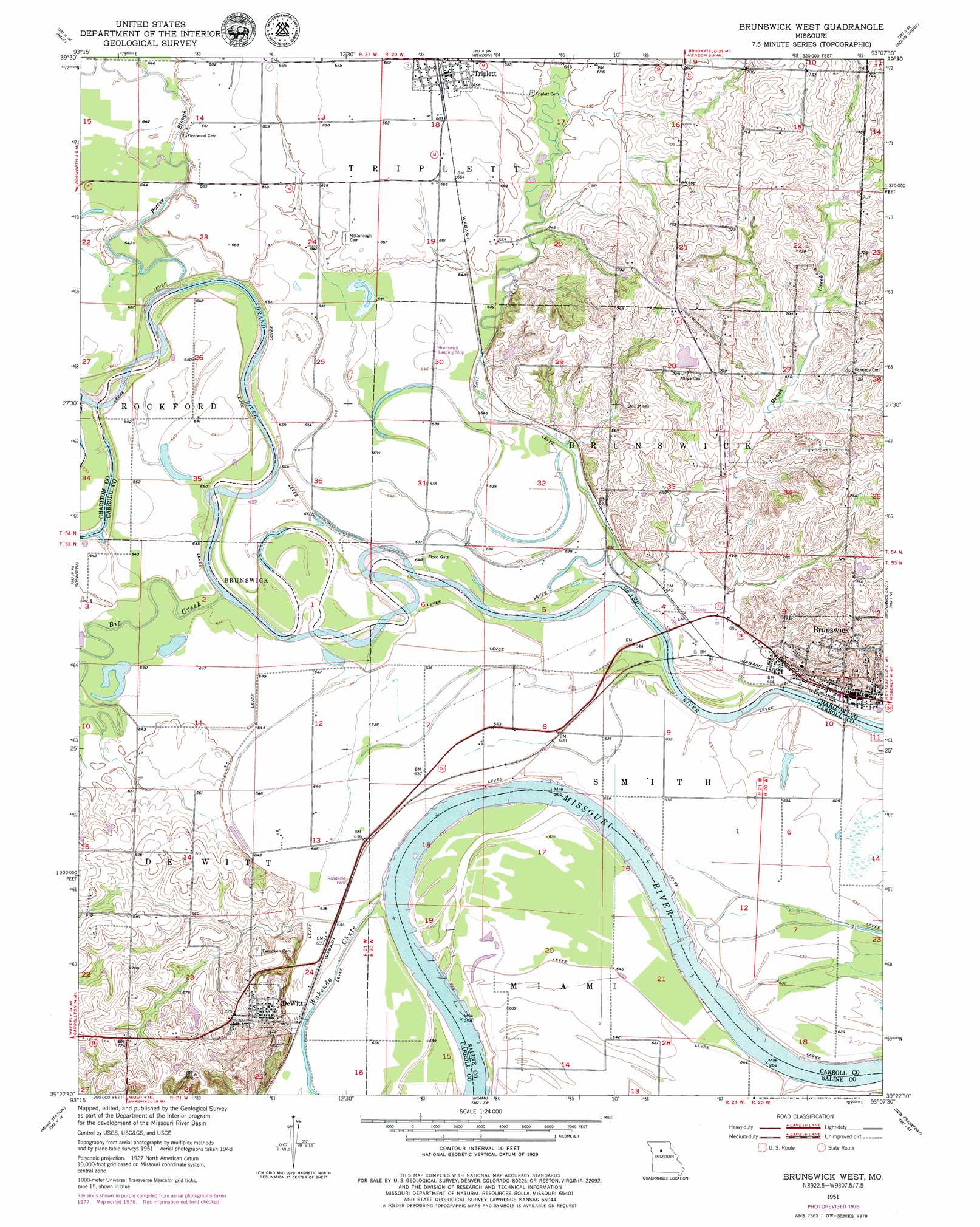
Brunswick West Topo Map Missouri
To zoom in, hover over the map of Brunswick West
USGS Topo Quad 39093d2 - 1:24,000 scale
| Topo Map Name: | Brunswick West |
| USGS Topo Quad ID: | 39093d2 |
| Print Size: | ca. 21 1/4" wide x 27" high |
| Southeast Coordinates: | 39.375° N latitude / 93.125° W longitude |
| Map Center Coordinates: | 39.4375° N latitude / 93.1875° W longitude |
| U.S. State: | MO |
| Filename: | o39093d2.jpg |
| Download Map JPG Image: | Brunswick West topo map 1:24,000 scale |
| Map Type: | Topographic |
| Topo Series: | 7.5´ |
| Map Scale: | 1:24,000 |
| Source of Map Images: | United States Geological Survey (USGS) |
| Alternate Map Versions: |
Brunswick West MO 1951, updated 1952 Download PDF Buy paper map Brunswick West MO 1951, updated 1952 Download PDF Buy paper map Brunswick West MO 2012 Download PDF Buy paper map Brunswick West MO 2015 Download PDF Buy paper map |
1:24,000 Topo Quads surrounding Brunswick West
Avalon |
Fountain Grove |
Sumner |
Rothville |
Marceline |
Tina |
Hale |
Mendon |
Indian Grove |
Mike |
Standish |
Bosworth |
Brunswick West |
Brunswick East |
Keytesville |
Carrollton East |
Miami Station |
Miami |
New Frankfort |
Cambridge |
Grand Pass |
Malta Bend |
Marshall North |
Slater |
Saline City |
> Back to 39093a1 at 1:100,000 scale
> Back to 39092a1 at 1:250,000 scale
> Back to U.S. Topo Maps home
Brunswick West topo map: Gazetteer
Brunswick West: Airports
Stephens and Akeman Airport elevation 195m 639′Brunswick West: Bends
Brunswick Bend elevation 189m 620′Dewitt Bend elevation 190m 623′
Brunswick West: Dams
East Lake Dam elevation 194m 636′Horseshoe Lake Dam elevation 194m 636′
Moore Lake Dam elevation 223m 731′
Number 155 Dam elevation 214m 702′
Brunswick West: Guts
Potter Slough elevation 193m 633′Brunswick West: Populated Places
Brunswick elevation 198m 649′De Witt elevation 226m 741′
Triplett elevation 201m 659′
Brunswick West: Reservoirs
East Lake elevation 194m 636′Moore Lake elevation 223m 731′
Brunswick West: Streams
Big Creek elevation 192m 629′Brush Creek elevation 194m 636′
Salt Branch elevation 189m 620′
Salt Creek elevation 189m 620′
Wakenda Chute elevation 193m 633′
Brunswick West digital topo map on disk
Buy this Brunswick West topo map showing relief, roads, GPS coordinates and other geographical features, as a high-resolution digital map file on DVD: