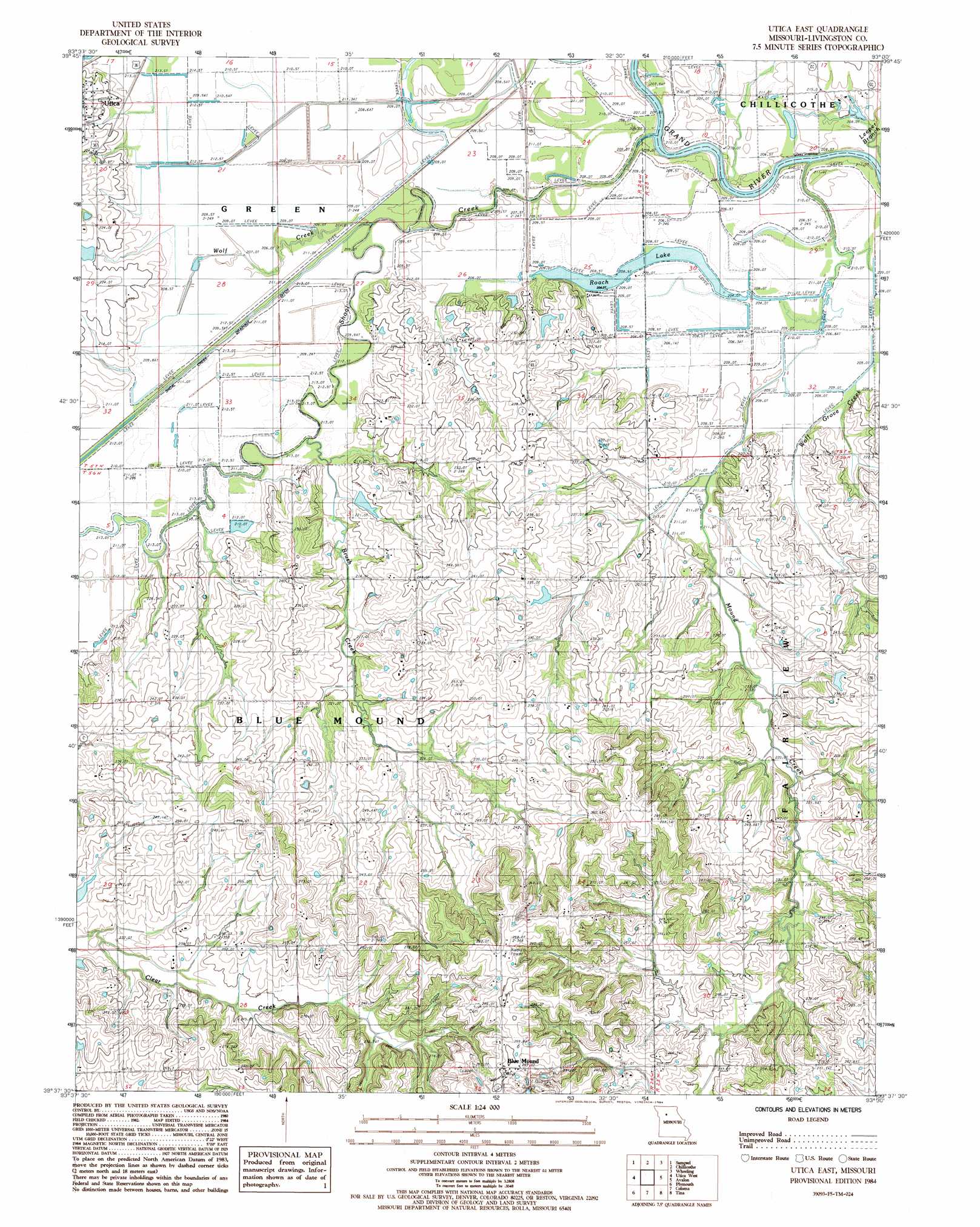
Utica East Topo Map Missouri
To zoom in, hover over the map of Utica East
USGS Topo Quad 39093f5 - 1:24,000 scale
| Topo Map Name: | Utica East |
| USGS Topo Quad ID: | 39093f5 |
| Print Size: | ca. 21 1/4" wide x 27" high |
| Southeast Coordinates: | 39.625° N latitude / 93.5° W longitude |
| Map Center Coordinates: | 39.6875° N latitude / 93.5625° W longitude |
| U.S. State: | MO |
| Filename: | o39093f5.jpg |
| Download Map JPG Image: | Utica East topo map 1:24,000 scale |
| Map Type: | Topographic |
| Topo Series: | 7.5´ |
| Map Scale: | 1:24,000 |
| Source of Map Images: | United States Geological Survey (USGS) |
| Alternate Map Versions: |
Utica East MO 1984, updated 1984 Download PDF Buy paper map Utica East MO 2012 Download PDF Buy paper map Utica East MO 2015 Download PDF Buy paper map |
1:24,000 Topo Quads surrounding Utica East
Jamesport |
Shearwood |
Farmersville |
Chula |
Eversonville |
Breckenridge |
Sampsel |
Chillicothe |
Wheeling |
Meadville |
Flat Creek |
Utica West |
Utica East |
Avalon |
Fountain Grove |
Braymer |
Plymouth |
Coloma |
Tina |
Hale |
Stet |
Roads |
Bogard |
Standish |
Bosworth |
> Back to 39093e1 at 1:100,000 scale
> Back to 39092a1 at 1:250,000 scale
> Back to U.S. Topo Maps home
Utica East topo map: Gazetteer
Utica East: Dams
Englert Lake Dam elevation 213m 698′Moore Lake Dam elevation 225m 738′
Savage Lake Dam elevation 233m 764′
Utica East: Lakes
Roach Lake elevation 205m 672′Utica East: Populated Places
Blue Mound elevation 300m 984′Cleary elevation 208m 682′
Utica East: Post Offices
Blue Mound Post Office elevation 300m 984′Utica East: Reservoirs
Englert Lake elevation 213m 698′Mononame 58 Lake elevation 233m 764′
Utica East: Streams
Blackwell Branch elevation 207m 679′Brush Creek elevation 208m 682′
Leeper Branch elevation 205m 672′
Mound Creek elevation 204m 669′
Shoal Creek elevation 205m 672′
Wolf Creek elevation 205m 672′
Wolf Grove Creek elevation 206m 675′
Utica East digital topo map on disk
Buy this Utica East topo map showing relief, roads, GPS coordinates and other geographical features, as a high-resolution digital map file on DVD: