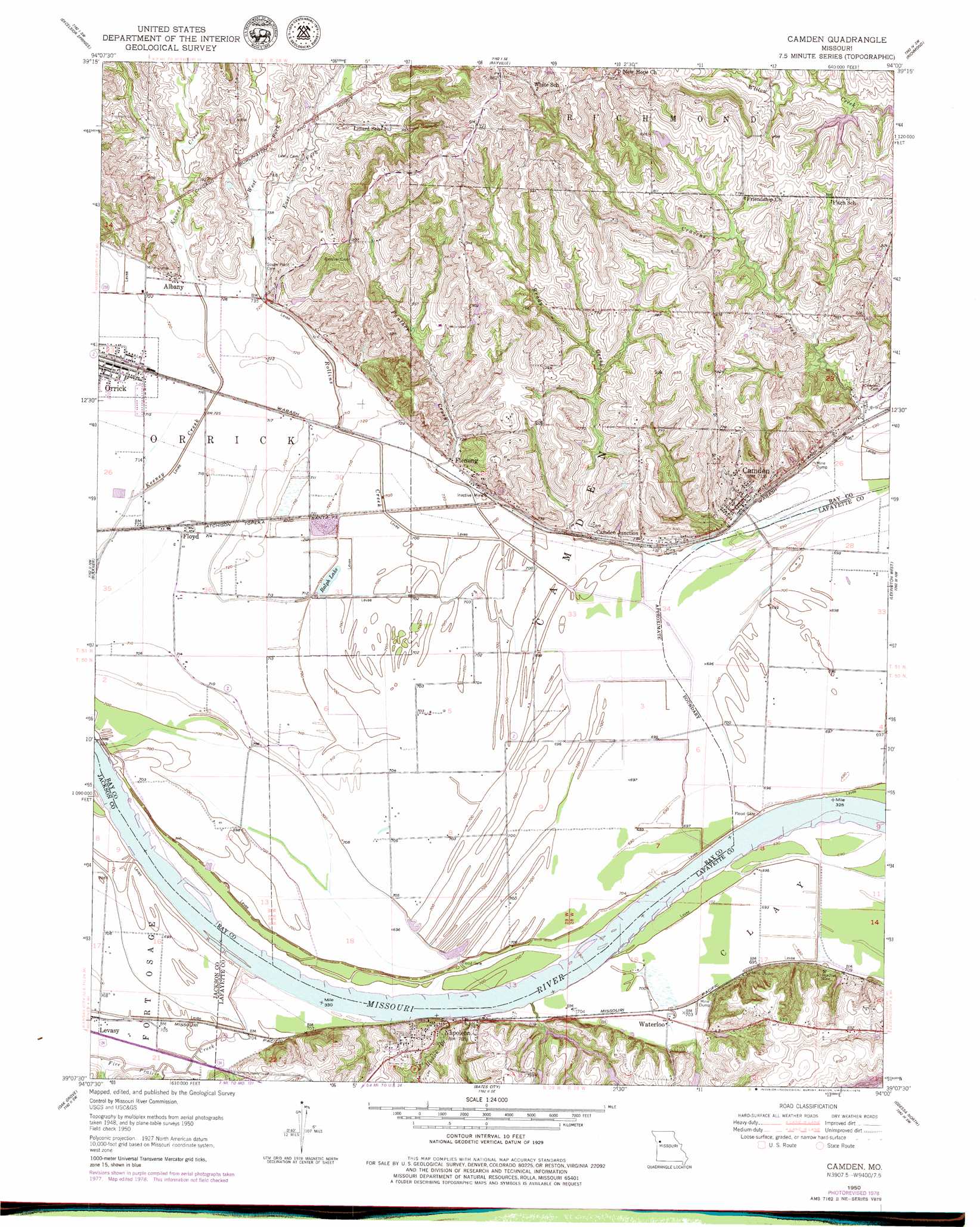
Camden Topo Map Missouri
To zoom in, hover over the map of Camden
USGS Topo Quad 39094b1 - 1:24,000 scale
| Topo Map Name: | Camden |
| USGS Topo Quad ID: | 39094b1 |
| Print Size: | ca. 21 1/4" wide x 27" high |
| Southeast Coordinates: | 39.125° N latitude / 94° W longitude |
| Map Center Coordinates: | 39.1875° N latitude / 94.0625° W longitude |
| U.S. State: | MO |
| Filename: | o39094b1.jpg |
| Download Map JPG Image: | Camden topo map 1:24,000 scale |
| Map Type: | Topographic |
| Topo Series: | 7.5´ |
| Map Scale: | 1:24,000 |
| Source of Map Images: | United States Geological Survey (USGS) |
| Alternate Map Versions: |
Camden MO 1950, updated 1955 Download PDF Buy paper map Camden MO 1950, updated 1964 Download PDF Buy paper map Camden MO 1950, updated 1969 Download PDF Buy paper map Camden MO 1950, updated 1979 Download PDF Buy paper map Camden MO 1951 Download PDF Buy paper map Camden MO 2012 Download PDF Buy paper map Camden MO 2015 Download PDF Buy paper map |
1:24,000 Topo Quads surrounding Camden
Holt |
Lawson |
Knoxville |
Millville |
Stet |
Kearney |
Excelsior Springs |
Rayville |
Richmond |
Hardin |
Missouri City |
Buckner |
Camden |
Lexington West |
Lexington East |
Blue Springs |
Oak Grove |
Bates City |
Odessa North |
Mayview |
Lake Jacomo |
Tarsney Lakes |
Chapel Hill |
Odessa South |
Fayetteville |
> Back to 39094a1 at 1:100,000 scale
> Back to 39094a1 at 1:250,000 scale
> Back to U.S. Topo Maps home
Camden topo map: Gazetteer
Camden: Bends
Camden Bend elevation 209m 685′Napolean Bend elevation 211m 692′
Camden: Dams
Bates City Quad Number 2 Dam elevation 230m 754′Lorelei Subdivision Lake Dam elevation 236m 774′
Ray County Dam Number A-27 elevation 223m 731′
Tanner Lake Dam elevation 251m 823′
Wellington-Naploeon Watershed Structure B-22 Dam elevation 220m 721′
Wellington-Napoleon Watershed Structure B-23 Dam elevation 232m 761′
Wellington-Napoleon Watershed Structure D-21b Dam elevation 216m 708′
Camden: Lakes
Big Lake (historical) elevation 213m 698′Ralph Lake elevation 213m 698′
Camden: Mines
Exchange Mine elevation 223m 731′Camden: Populated Places
Albany elevation 226m 741′Camden elevation 223m 731′
Camden Junction elevation 226m 741′
Fleming elevation 224m 734′
Floyd elevation 219m 718′
Napoleon elevation 225m 738′
Orrick elevation 219m 718′
Waterloo elevation 215m 705′
Camden: Reservoirs
Ray County Number A-27 Lake elevation 223m 731′Tanner Lake elevation 251m 823′
Camden: Streams
Brady Creek elevation 210m 688′East Fork Rollins Creek elevation 224m 734′
Fire Prairie Creek elevation 211m 692′
Hicklin Branch elevation 212m 695′
Panther Creek elevation 213m 698′
Rollins Creek elevation 212m 695′
Shumate Branch elevation 214m 702′
West Fork Rollins Creek elevation 224m 734′
Camden digital topo map on disk
Buy this Camden topo map showing relief, roads, GPS coordinates and other geographical features, as a high-resolution digital map file on DVD: