Basehor Topo Map Kansas
To zoom in, hover over the map of Basehor
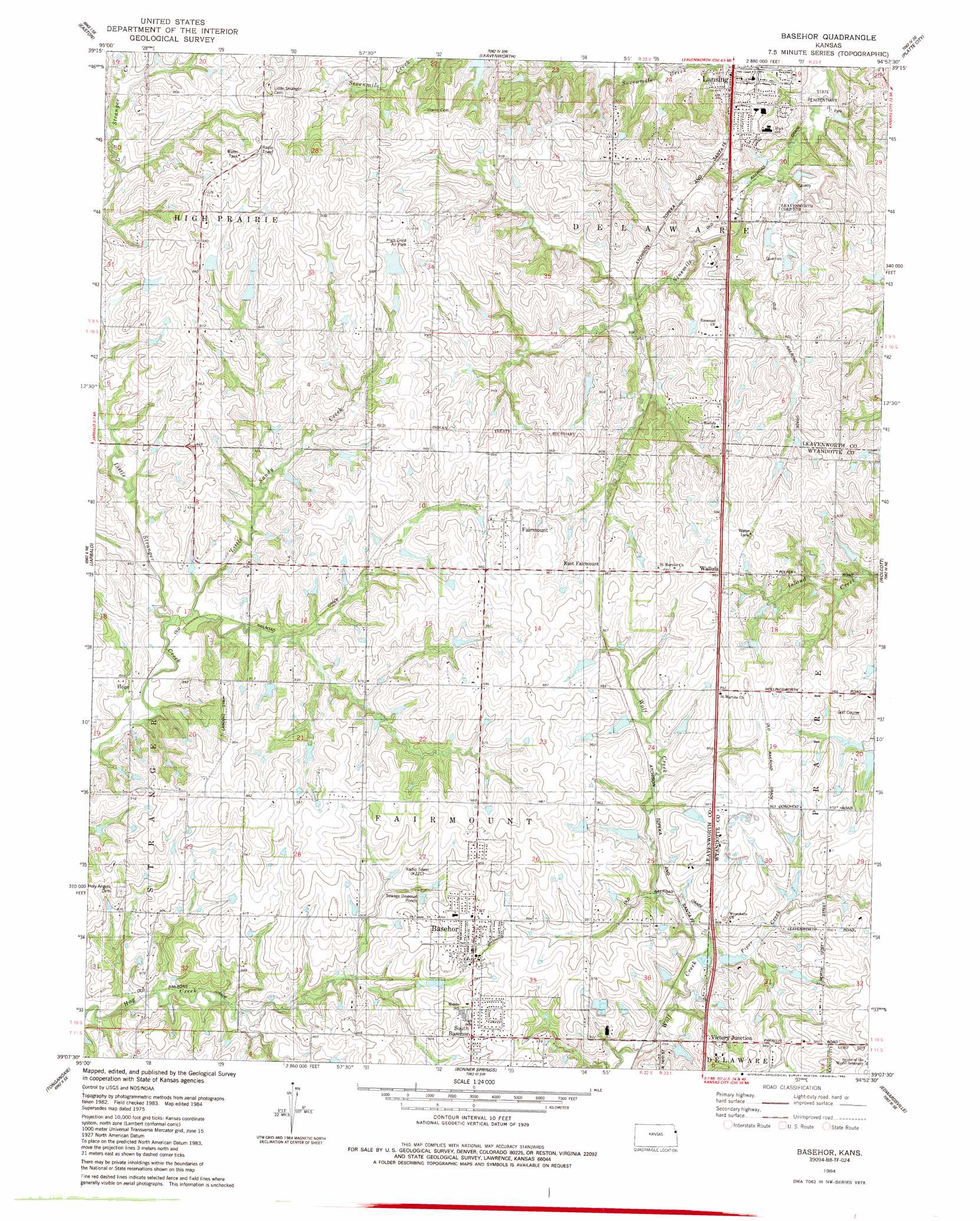
USGS Topo Quad 39094b8 - 1:24,000 scale
| Topo Map Name: | Basehor |
| USGS Topo Quad ID: | 39094b8 |
| Print Size: | ca. 21 1/4" wide x 27" high |
| Southeast Coordinates: | 39.125° N latitude / 94.875° W longitude |
| Map Center Coordinates: | 39.1875° N latitude / 94.9375° W longitude |
| U.S. State: | KS |
| Filename: | o39094b8.jpg |
| Download Map JPG Image: | Basehor topo map 1:24,000 scale |
| Map Type: | Topographic |
| Topo Series: | 7.5´ |
| Map Scale: | 1:24,000 |
| Source of Map Images: | United States Geological Survey (USGS) |
| Alternate Map Versions: |
Basehor KS 1949, updated 1976 Download PDF Buy paper map Basehor KS 1950 Download PDF Buy paper map Basehor KS 1950, updated 1971 Download PDF Buy paper map Basehor KS 1984, updated 1984 Download PDF Buy paper map Basehor KS 2009 Download PDF Buy paper map Basehor KS 2012 Download PDF Buy paper map Basehor KS 2015 Download PDF Buy paper map |
1:24,000 Topo Quads surrounding Basehor
Potter |
Oak Mills |
Weston |
Tracy |
Camden Point |
Easton Sw |
Easton |
Leavenworth |
Platte City |
Ferrelview |
Mclouth |
Jarbalo |
Basehor |
Wolcott |
Parkville |
Midland |
Tonganoxie |
Bonner Springs |
Edwardsville |
Shawnee |
Lawrence East |
Eudora |
De Soto |
Olathe |
Lenexa |
> Back to 39094a1 at 1:100,000 scale
> Back to 39094a1 at 1:250,000 scale
> Back to U.S. Topo Maps home
Basehor topo map: Gazetteer
Basehor: Airports
High Crest Air Park elevation 309m 1013′Neu Field elevation 286m 938′
Basehor: Crossings
Bonner Springs Interchange elevation 282m 925′Basehor: Populated Places
Basehor elevation 299m 980′East Fairmount elevation 296m 971′
Fairmount elevation 297m 974′
Hoge elevation 259m 849′
Lansing elevation 258m 846′
South Basehor elevation 295m 967′
Stone elevation 272m 892′
Victory Junction elevation 289m 948′
Wallula elevation 303m 994′
Wildwoods Mobile Home Park elevation 240m 787′
Basehor: Post Offices
Basehor Post Office elevation 296m 971′Basehor: Streams
Little Sandy Creek elevation 259m 849′Piper Creek elevation 263m 862′
Basehor digital topo map on disk
Buy this Basehor topo map showing relief, roads, GPS coordinates and other geographical features, as a high-resolution digital map file on DVD: