Ferrelview Topo Map Missouri
To zoom in, hover over the map of Ferrelview
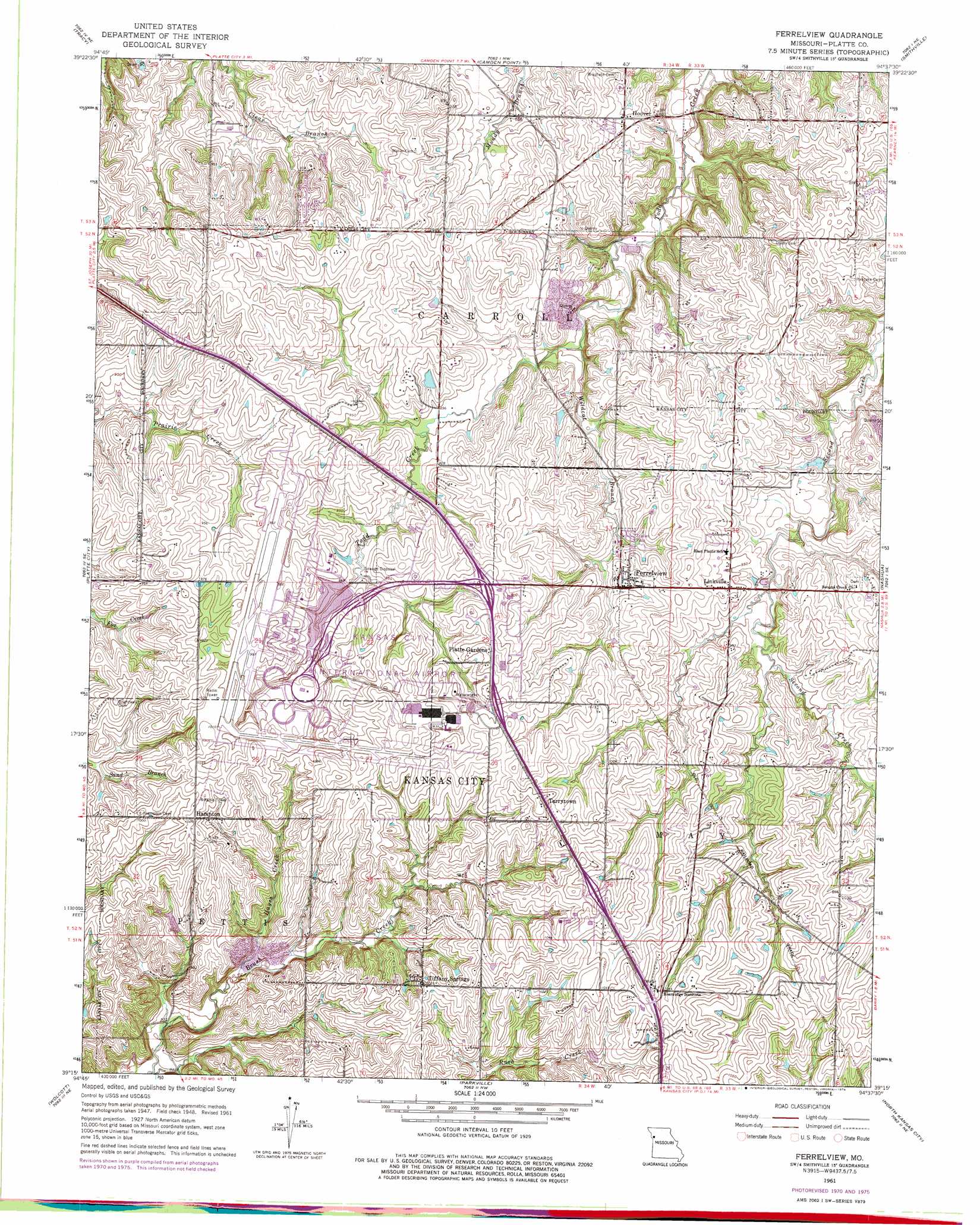
USGS Topo Quad 39094c6 - 1:24,000 scale
| Topo Map Name: | Ferrelview |
| USGS Topo Quad ID: | 39094c6 |
| Print Size: | ca. 21 1/4" wide x 27" high |
| Southeast Coordinates: | 39.25° N latitude / 94.625° W longitude |
| Map Center Coordinates: | 39.3125° N latitude / 94.6875° W longitude |
| U.S. State: | MO |
| Filename: | o39094c6.jpg |
| Download Map JPG Image: | Ferrelview topo map 1:24,000 scale |
| Map Type: | Topographic |
| Topo Series: | 7.5´ |
| Map Scale: | 1:24,000 |
| Source of Map Images: | United States Geological Survey (USGS) |
| Alternate Map Versions: |
Ferrelview MO 1950, updated 1950 Download PDF Buy paper map Ferrelview MO 1961, updated 1962 Download PDF Buy paper map Ferrelview MO 1961, updated 1971 Download PDF Buy paper map Ferrelview MO 1961, updated 1976 Download PDF Buy paper map Ferrelview MO 2012 Download PDF Buy paper map Ferrelview MO 2015 Download PDF Buy paper map |
1:24,000 Topo Quads surrounding Ferrelview
De Kalb |
Dearborn |
Edgerton |
Gower |
Plattsburg |
Weston |
Tracy |
Camden Point |
Smithville |
Arley |
Leavenworth |
Platte City |
Ferrelview |
Nashua |
Kearney Sw |
Basehor |
Wolcott |
Parkville |
North Kansas City |
Liberty |
Bonner Springs |
Edwardsville |
Shawnee |
Kansas City |
Independence |
> Back to 39094a1 at 1:100,000 scale
> Back to 39094a1 at 1:250,000 scale
> Back to U.S. Topo Maps home
Ferrelview topo map: Gazetteer
Ferrelview: Airports
Executive Hills Polo Club Heliport elevation 322m 1056′Kansas City International Airport elevation 294m 964′
Ferrelview: Crossings
Interchange 10 elevation 314m 1030′Interchange 12 elevation 305m 1000′
Interchange 13 elevation 304m 997′
Interchange 14 elevation 287m 941′
Interchange 15 elevation 286m 938′
Interchange 17 elevation 282m 925′
Interchange 31 elevation 282m 925′
Interchange 36 elevation 294m 964′
Interchange 37 elevation 287m 941′
Interchange 9A and 9B elevation 317m 1040′
Ferrelview: Dams
Basswood Dam elevation 275m 902′Gray Lake Dam elevation 284m 931′
Hanks Lake Dam elevation 280m 918′
International Airport Dam elevation 291m 954′
Sampson Lake Dam elevation 298m 977′
Ferrelview: Populated Places
Ferrelview elevation 290m 951′Hampton elevation 311m 1020′
Hoover elevation 272m 892′
Linkville elevation 293m 961′
Platte Gardens elevation 311m 1020′
Tarrytown elevation 324m 1062′
Tiffany Springs elevation 311m 1020′
Ferrelview: Reservoirs
Basswood Lake elevation 275m 902′Berlin Reservoir elevation 291m 954′
Gray Lake elevation 284m 931′
Hanks Lake elevation 280m 918′
Sampson Lake elevation 298m 977′
Ferrelview: Streams
Hayes Creek elevation 259m 849′Wildcat Branch elevation 255m 836′
Ferrelview digital topo map on disk
Buy this Ferrelview topo map showing relief, roads, GPS coordinates and other geographical features, as a high-resolution digital map file on DVD: