Agency Topo Map Missouri
To zoom in, hover over the map of Agency
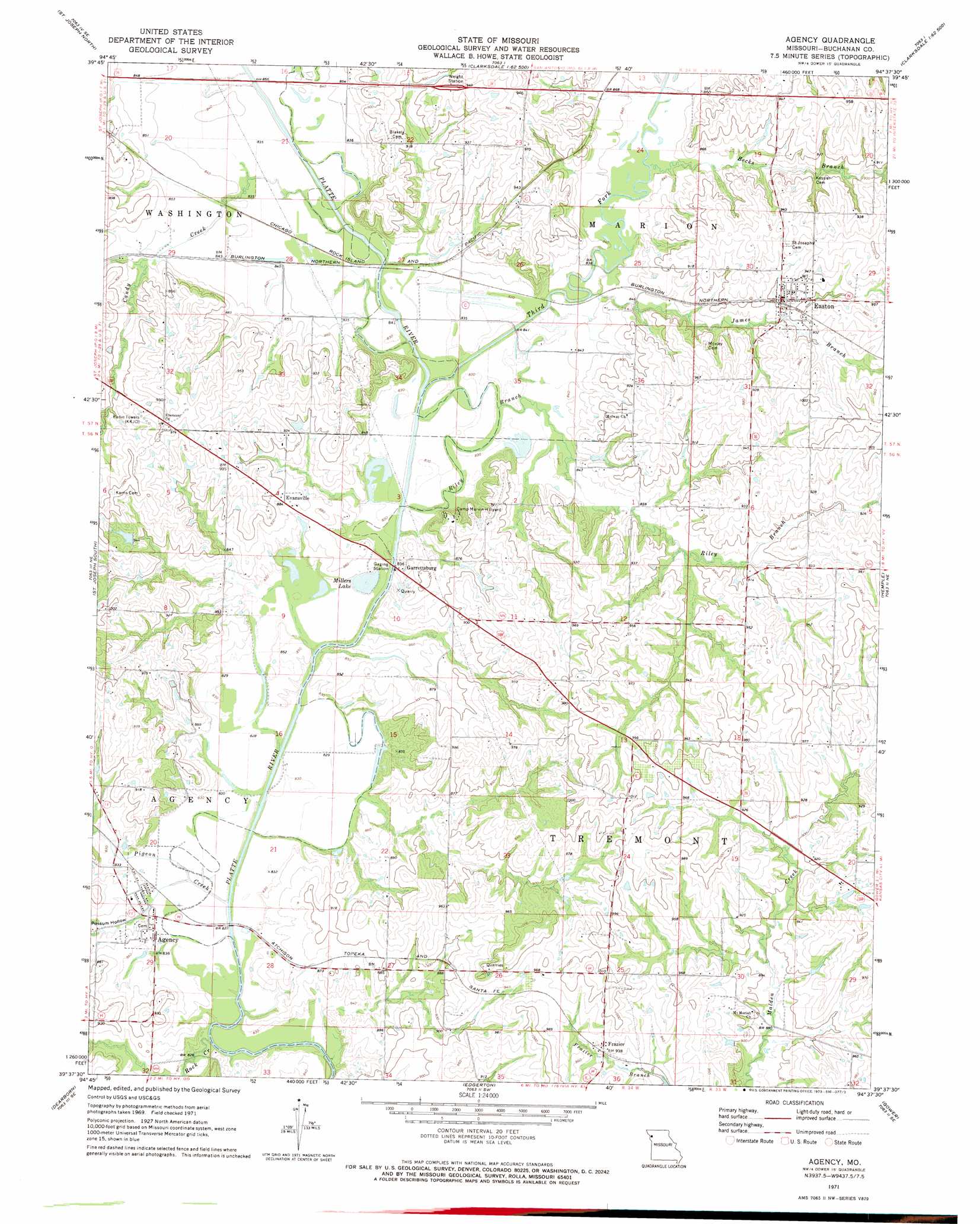
USGS Topo Quad 39094f6 - 1:24,000 scale
| Topo Map Name: | Agency |
| USGS Topo Quad ID: | 39094f6 |
| Print Size: | ca. 21 1/4" wide x 27" high |
| Southeast Coordinates: | 39.625° N latitude / 94.625° W longitude |
| Map Center Coordinates: | 39.6875° N latitude / 94.6875° W longitude |
| U.S. State: | MO |
| Filename: | o39094f6.jpg |
| Download Map JPG Image: | Agency topo map 1:24,000 scale |
| Map Type: | Topographic |
| Topo Series: | 7.5´ |
| Map Scale: | 1:24,000 |
| Source of Map Images: | United States Geological Survey (USGS) |
| Alternate Map Versions: |
Agency MO 1971, updated 1973 Download PDF Buy paper map Agency MO 2012 Download PDF Buy paper map Agency MO 2014 Download PDF Buy paper map |
1:24,000 Topo Quads surrounding Agency
Amazonia |
Savannah |
Helena |
Union Star |
Wood |
Wathena |
Saint Joseph North |
Cosby |
Clarksdale |
Amity |
Halls |
Saint Joseph South |
Agency |
Hemple |
Perrin |
De Kalb |
Dearborn |
Edgerton |
Gower |
Plattsburg |
Weston |
Tracy |
Camden Point |
Smithville |
Arley |
> Back to 39094e1 at 1:100,000 scale
> Back to 39094a1 at 1:250,000 scale
> Back to U.S. Topo Maps home
Agency topo map: Gazetteer
Agency: Dams
Ehlert Lake Dam elevation 285m 935′Woodbury Lake Dam elevation 274m 898′
Agency: Lakes
Millers Lake elevation 253m 830′Thompson Lake (historical) elevation 252m 826′
Agency: Populated Places
Agency elevation 252m 826′Easton elevation 281m 921′
Evansville elevation 269m 882′
Frazier elevation 282m 925′
Garrettsburg elevation 268m 879′
Agency: Reservoirs
Ehlert Lake elevation 285m 935′Woodbury Lake elevation 274m 898′
Agency: Streams
Becks Branch elevation 255m 836′Candy Creek elevation 249m 816′
James Branch elevation 250m 820′
One Hundred and Two River elevation 251m 823′
Pigeon Creek elevation 250m 820′
Riley Branch elevation 250m 820′
Rock Creek elevation 248m 813′
Third Fork elevation 250m 820′
Agency: Valleys
Possum Hollow elevation 251m 823′Agency digital topo map on disk
Buy this Agency topo map showing relief, roads, GPS coordinates and other geographical features, as a high-resolution digital map file on DVD: