Saint Joseph South Topo Map Missouri
To zoom in, hover over the map of Saint Joseph South
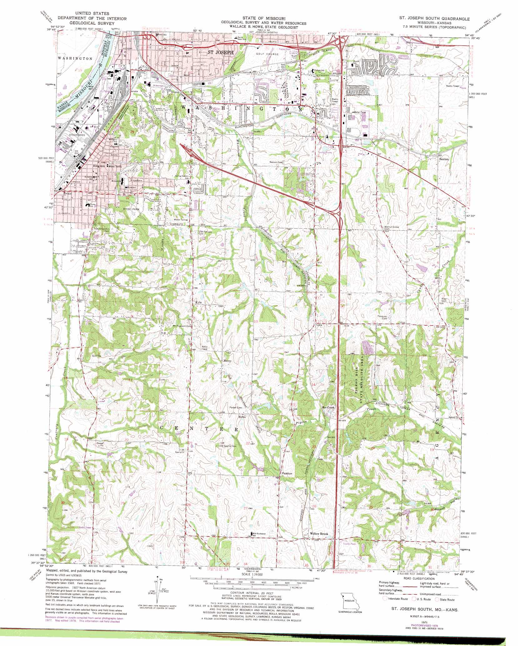
USGS Topo Quad 39094f7 - 1:24,000 scale
| Topo Map Name: | Saint Joseph South |
| USGS Topo Quad ID: | 39094f7 |
| Print Size: | ca. 21 1/4" wide x 27" high |
| Southeast Coordinates: | 39.625° N latitude / 94.75° W longitude |
| Map Center Coordinates: | 39.6875° N latitude / 94.8125° W longitude |
| U.S. States: | MO, KS |
| Filename: | o39094f7.jpg |
| Download Map JPG Image: | Saint Joseph South topo map 1:24,000 scale |
| Map Type: | Topographic |
| Topo Series: | 7.5´ |
| Map Scale: | 1:24,000 |
| Source of Map Images: | United States Geological Survey (USGS) |
| Alternate Map Versions: |
St. Joseph South MO 1971, updated 1973 Download PDF Buy paper map St. Joseph South MO 1971, updated 1978 Download PDF Buy paper map St. Joseph South MO 1971, updated 1978 Download PDF Buy paper map St. Joseph South MO 1980, updated 1981 Download PDF Buy paper map Saint Joseph South MO 2009 Download PDF Buy paper map Saint Joseph South MO 2012 Download PDF Buy paper map Saint Joseph South MO 2015 Download PDF Buy paper map |
1:24,000 Topo Quads surrounding Saint Joseph South
Forbes |
Amazonia |
Savannah |
Helena |
Union Star |
Troy |
Wathena |
Saint Joseph North |
Cosby |
Clarksdale |
Atchison Ne |
Halls |
Saint Joseph South |
Agency |
Hemple |
Atchison East |
De Kalb |
Dearborn |
Edgerton |
Gower |
Oak Mills |
Weston |
Tracy |
Camden Point |
Smithville |
> Back to 39094e1 at 1:100,000 scale
> Back to 39094a1 at 1:250,000 scale
> Back to U.S. Topo Maps home
Saint Joseph South topo map: Gazetteer
Saint Joseph South: Airports
Butchs Strip elevation 300m 984′Saint Joseph South: Dams
Komer Lake Dam elevation 296m 971′Lake Flamingo Dam elevation 276m 905′
Little Ozark Fishing Lake Dam elevation 285m 935′
McPheeters Lake Dam elevation 274m 898′
Ralphs Lake Dam elevation 296m 971′
Swanson Lake Dam elevation 329m 1079′
Ussary Dam elevation 283m 928′
Saint Joseph South: Parks
Hyde Park elevation 283m 928′Pigeon Hill State Wildlife Area elevation 287m 941′
Saint Joseph South: Populated Places
Ashton (historical) elevation 303m 994′Kyle elevation 341m 1118′
Matney elevation 302m 990′
Maxey elevation 327m 1072′
Pinkston elevation 301m 987′
Richie elevation 339m 1112′
Saxton elevation 272m 892′
Sparta elevation 348m 1141′
Willow Brook elevation 310m 1017′
Saint Joseph South: Reservoirs
Komer Lake elevation 296m 971′Lake Flamingo elevation 276m 905′
Little Ozark Fishing Lake elevation 285m 935′
McPheeters Lake elevation 274m 898′
Ralphs Lake elevation 296m 971′
Swanson Lake elevation 329m 1079′
Ussary Lake elevation 283m 928′
Saint Joseph South: Streams
Lost Creek elevation 259m 849′Whitehead Creek elevation 245m 803′
Saint Joseph South: Summits
King Hill elevation 323m 1059′Saint Joseph South digital topo map on disk
Buy this Saint Joseph South topo map showing relief, roads, GPS coordinates and other geographical features, as a high-resolution digital map file on DVD: