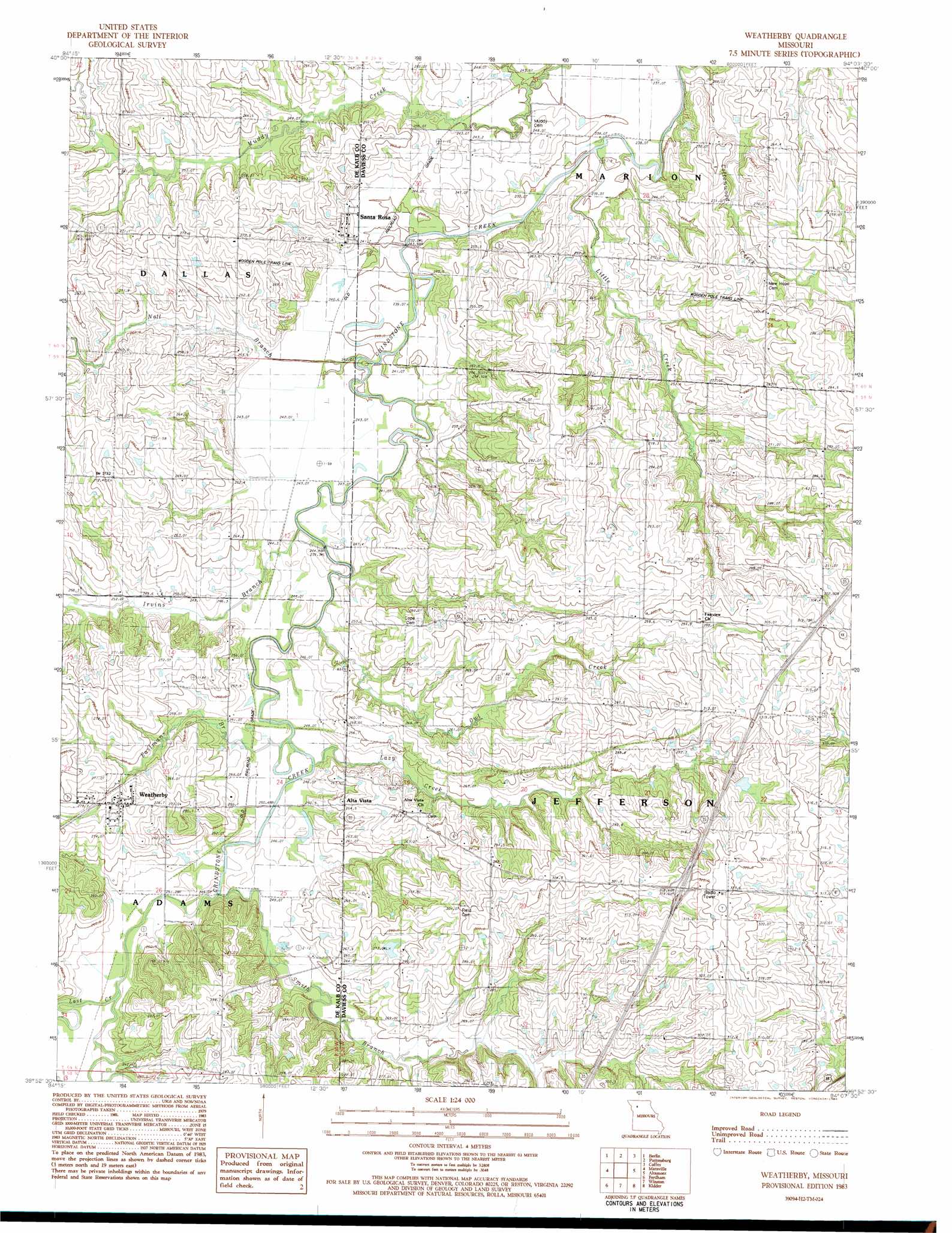
Weatherby Topo Map Missouri
To zoom in, hover over the map of Weatherby
USGS Topo Quad 39094h2 - 1:24,000 scale
| Topo Map Name: | Weatherby |
| USGS Topo Quad ID: | 39094h2 |
| Print Size: | ca. 21 1/4" wide x 27" high |
| Southeast Coordinates: | 39.875° N latitude / 94.125° W longitude |
| Map Center Coordinates: | 39.9375° N latitude / 94.1875° W longitude |
| U.S. State: | MO |
| Filename: | o39094h2.jpg |
| Download Map JPG Image: | Weatherby topo map 1:24,000 scale |
| Map Type: | Topographic |
| Topo Series: | 7.5´ |
| Map Scale: | 1:24,000 |
| Source of Map Images: | United States Geological Survey (USGS) |
| Alternate Map Versions: |
Weatherby MO 1983, updated 1984 Download PDF Buy paper map Weatherby MO 2012 Download PDF Buy paper map Weatherby MO 2014 Download PDF Buy paper map |
1:24,000 Topo Quads surrounding Weatherby
Darlington |
Albany South |
Matkin |
Mitchellville |
Gilman City West |
Ford City |
Berlin |
Pattonsburg |
Coffey |
Jameson |
Wood |
Maysville |
Weatherby |
Altamont |
Gallatin |
Amity |
Fordham |
Winston |
Kidder |
Nettleton |
Perrin |
Cameron West |
Cameron East |
Hamilton West |
Hamilton East |
> Back to 39094e1 at 1:100,000 scale
> Back to 39094a1 at 1:250,000 scale
> Back to U.S. Topo Maps home
Weatherby topo map: Gazetteer
Weatherby: Dams
Grindstone-Lost Muddy Creek Watershed Dam F-30 elevation 292m 958′Grindstone-Lost-Muddy Creek Watershed Dam F-20 elevation 273m 895′
Grindstone-Lost-Muddy Creek Watershed Dam F-32 elevation 284m 931′
Weatherby: Populated Places
Alta Vista elevation 265m 869′Santa Rosa elevation 247m 810′
Weatherby elevation 268m 879′
Weatherby: Post Offices
Brownsdale Post Office elevation 300m 984′Weatherby: Streams
Cottonwood Creek elevation 236m 774′Eastmans Branch elevation 244m 800′
Irvins Branch elevation 240m 787′
Lazy Creek elevation 248m 813′
Little Creek elevation 237m 777′
Lost Creek elevation 248m 813′
Noll Branch elevation 236m 774′
Owl Creek elevation 243m 797′
Smith Branch elevation 248m 813′
Weatherby digital topo map on disk
Buy this Weatherby topo map showing relief, roads, GPS coordinates and other geographical features, as a high-resolution digital map file on DVD: