Olsburg Nw Topo Map Kansas
To zoom in, hover over the map of Olsburg Nw
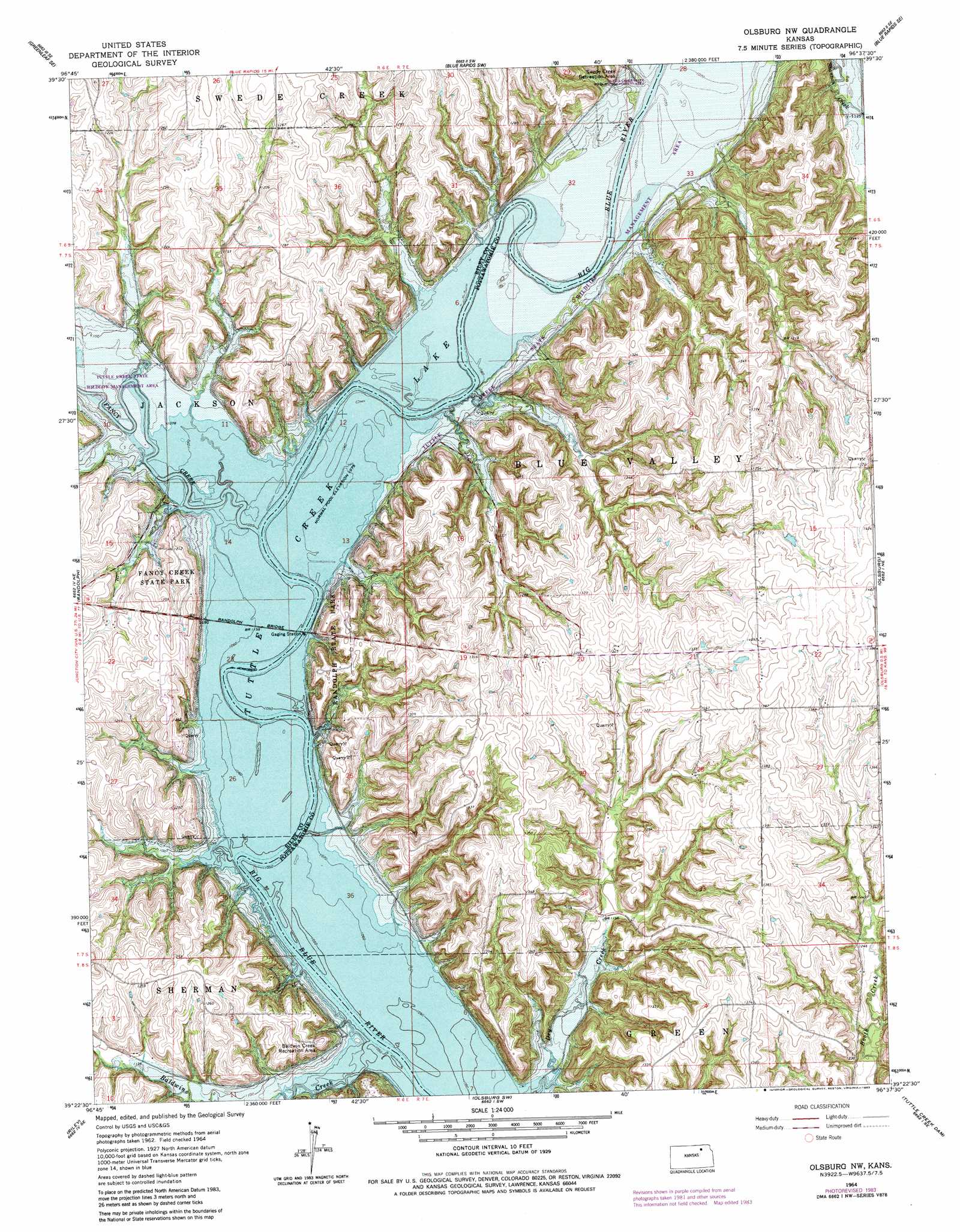
USGS Topo Quad 39096d6 - 1:24,000 scale
| Topo Map Name: | Olsburg Nw |
| USGS Topo Quad ID: | 39096d6 |
| Print Size: | ca. 21 1/4" wide x 27" high |
| Southeast Coordinates: | 39.375° N latitude / 96.625° W longitude |
| Map Center Coordinates: | 39.4375° N latitude / 96.6875° W longitude |
| U.S. State: | KS |
| Filename: | o39096d6.jpg |
| Download Map JPG Image: | Olsburg Nw topo map 1:24,000 scale |
| Map Type: | Topographic |
| Topo Series: | 7.5´ |
| Map Scale: | 1:24,000 |
| Source of Map Images: | United States Geological Survey (USGS) |
| Alternate Map Versions: |
Olsburg NW KS 1964, updated 1965 Download PDF Buy paper map Olsburg NW KS 1964, updated 1978 Download PDF Buy paper map Olsburg NW KS 1964, updated 1983 Download PDF Buy paper map Olsburg NW KS 2009 Download PDF Buy paper map Olsburg NW KS 2012 Download PDF Buy paper map Olsburg NW KS 2015 Download PDF Buy paper map |
1:24,000 Topo Quads surrounding Olsburg Nw
Greenleaf |
Barnes |
Blue Rapids |
Blue Rapids Ne |
Frankfort |
Kimeo |
Greenleaf Se |
Blue Rapids Sw |
Blue Rapids Se |
Frankfort Sw |
Lasita |
Randolph |
Olsburg Nw |
Olsburg |
Westmoreland |
Bala |
Riley |
Olsburg Sw |
Tuttle Creek Dam |
Flush |
Milford |
Fort Riley Ne |
Keats |
Manhattan |
Saint George |
> Back to 39096a1 at 1:100,000 scale
> Back to 39096a1 at 1:250,000 scale
> Back to U.S. Topo Maps home
Olsburg Nw topo map: Gazetteer
Olsburg Nw: Bridges
Randolph Bridge elevation 327m 1072′Olsburg Nw: Parks
Baldwin Creek Recreation Area elevation 373m 1223′Fancy Creek State Park elevation 364m 1194′
Randolph State Park elevation 352m 1154′
Tuttle Creek Wildlife Area elevation 327m 1072′
Olsburg Nw: Streams
Baldwin Creek elevation 327m 1072′Fancy Creek elevation 327m 1072′
Swede Creek elevation 324m 1062′
Olsburg Nw digital topo map on disk
Buy this Olsburg Nw topo map showing relief, roads, GPS coordinates and other geographical features, as a high-resolution digital map file on DVD: