Vesper Topo Map Kansas
To zoom in, hover over the map of Vesper
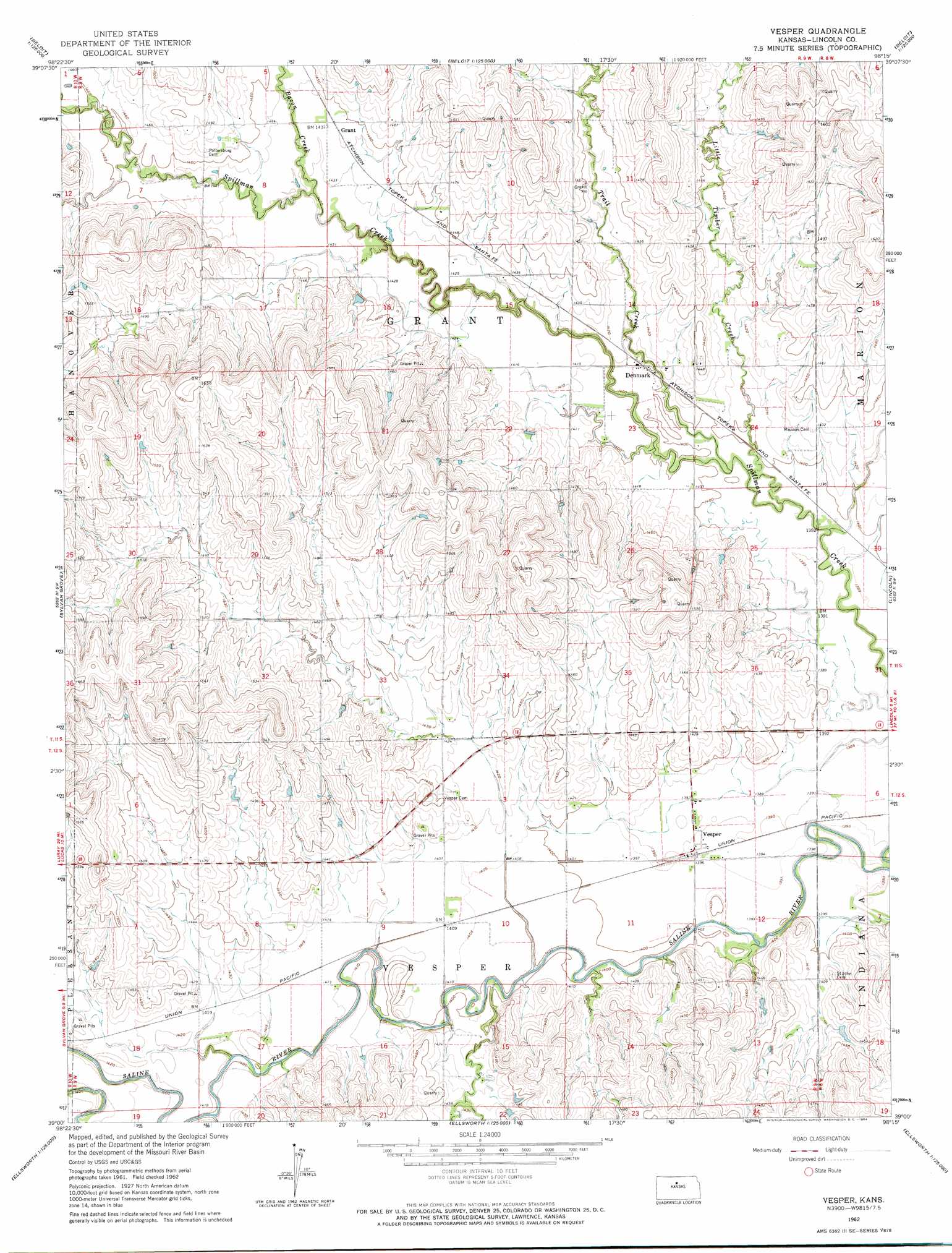
USGS Topo Quad 39098a3 - 1:24,000 scale
| Topo Map Name: | Vesper |
| USGS Topo Quad ID: | 39098a3 |
| Print Size: | ca. 21 1/4" wide x 27" high |
| Southeast Coordinates: | 39° N latitude / 98.25° W longitude |
| Map Center Coordinates: | 39.0625° N latitude / 98.3125° W longitude |
| U.S. State: | KS |
| Filename: | o39098a3.jpg |
| Download Map JPG Image: | Vesper topo map 1:24,000 scale |
| Map Type: | Topographic |
| Topo Series: | 7.5´ |
| Map Scale: | 1:24,000 |
| Source of Map Images: | United States Geological Survey (USGS) |
| Alternate Map Versions: |
Vesper KS 1962, updated 1964 Download PDF Buy paper map Vesper KS 2009 Download PDF Buy paper map Vesper KS 2012 Download PDF Buy paper map Vesper KS 2015 Download PDF Buy paper map |
1:24,000 Topo Quads surrounding Vesper
Osborne Se |
Tipton |
Blue Hill |
Beloit Sw |
Beloit Se |
Meades Ranch |
Hunter |
Ash Grove |
Lincoln Nw |
Barnard |
Lucas |
Sylvan Grove |
Vesper |
Lincoln |
Shady Bend |
Dorrance Ne |
Wilson Nw |
Wilson Ne |
Westfall Nw |
Westfall |
Dorrance |
Wilson |
Black Wolf |
Westfall Sw |
Westfall Se |
> Back to 39098a1 at 1:100,000 scale
> Back to 39098a1 at 1:250,000 scale
> Back to U.S. Topo Maps home
Vesper topo map: Gazetteer
Vesper: Populated Places
Denmark elevation 430m 1410′Grant elevation 440m 1443′
Vesper elevation 425m 1394′
Vesper: Streams
Bacon Creek elevation 429m 1407′Little Timber Creek elevation 421m 1381′
Trail Creek elevation 424m 1391′
Vesper digital topo map on disk
Buy this Vesper topo map showing relief, roads, GPS coordinates and other geographical features, as a high-resolution digital map file on DVD: