Dawson Butte Topo Map Colorado
To zoom in, hover over the map of Dawson Butte
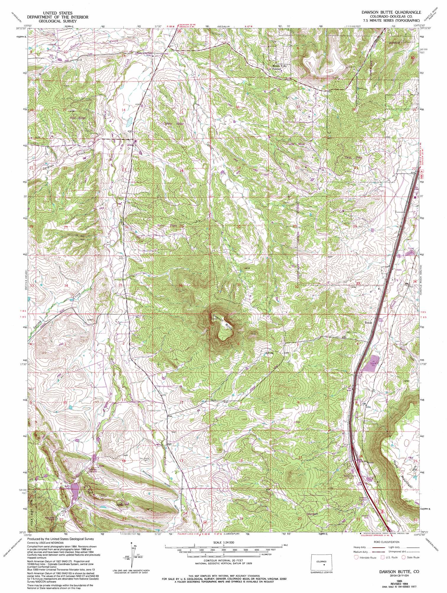
USGS Topo Quad 39104c8 - 1:24,000 scale
| Topo Map Name: | Dawson Butte |
| USGS Topo Quad ID: | 39104c8 |
| Print Size: | ca. 21 1/4" wide x 27" high |
| Southeast Coordinates: | 39.25° N latitude / 104.875° W longitude |
| Map Center Coordinates: | 39.3125° N latitude / 104.9375° W longitude |
| U.S. State: | CO |
| Filename: | o39104c8.jpg |
| Download Map JPG Image: | Dawson Butte topo map 1:24,000 scale |
| Map Type: | Topographic |
| Topo Series: | 7.5´ |
| Map Scale: | 1:24,000 |
| Source of Map Images: | United States Geological Survey (USGS) |
| Alternate Map Versions: |
Dawson Butte CO 1965, updated 1967 Download PDF Buy paper map Dawson Butte CO 1965, updated 1967 Download PDF Buy paper map Dawson Butte CO 1965, updated 1975 Download PDF Buy paper map Dawson Butte CO 1965, updated 1979 Download PDF Buy paper map Dawson Butte CO 1965, updated 1994 Download PDF Buy paper map Dawson Butte CO 1994, updated 1998 Download PDF Buy paper map Dawson Butte CO 2011 Download PDF Buy paper map Dawson Butte CO 2013 Download PDF Buy paper map Dawson Butte CO 2016 Download PDF Buy paper map |
| FStopo: | US Forest Service topo Dawson Butte is available: Download FStopo PDF Download FStopo TIF |
1:24,000 Topo Quads surrounding Dawson Butte
Indian Hills |
Littleton |
Highlands Ranch |
Parker |
Piney Creek |
Platte Canyon |
Kassler |
Sedalia |
Castle Rock North |
Ponderosa Park |
Deckers |
Devils Head |
Dawson Butte |
Castle Rock South |
Russellville Gulch |
Westcreek |
Dakan Mountain |
Larkspur |
Greenland |
Cherry Valley School |
Signal Butte |
Mount Deception |
Palmer Lake |
Monument |
Black Forest |
> Back to 39104a1 at 1:100,000 scale
> Back to 39104a1 at 1:250,000 scale
> Back to U.S. Topo Maps home
Dawson Butte topo map: Gazetteer
Dawson Butte: Canals
Benjamin Quick Ditch elevation 1945m 6381′Dawson Butte: Dams
Stevens Number 2 and 3 Dam elevation 1846m 6056′Waucondah Dam elevation 1948m 6391′
Dawson Butte: Flats
Perry Park elevation 1958m 6423′Dawson Butte: Mines
Perry Park Mine elevation 1953m 6407′Dawson Butte: Populated Places
Monte Vista Estates elevation 1940m 6364′Perry Park elevation 1971m 6466′
Tomah elevation 1961m 6433′
Dawson Butte: Reservoirs
Stevens Reservoir Number 2 and 3 elevation 1846m 6056′Waucondah Reservoir elevation 1948m 6391′
Dawson Butte: Streams
Bear Creek elevation 1891m 6204′Garber Creek elevation 1809m 5935′
Jackson Creek elevation 1855m 6085′
Spring Creek elevation 1867m 6125′
Dawson Butte: Summits
Dawson Butte elevation 2278m 7473′Hunt Mountain elevation 2215m 7267′
Dawson Butte: Valleys
Dry Gulch elevation 1899m 6230′Glade Gulch elevation 1964m 6443′
Hog John Gulch elevation 1946m 6384′
Dawson Butte digital topo map on disk
Buy this Dawson Butte topo map showing relief, roads, GPS coordinates and other geographical features, as a high-resolution digital map file on DVD: