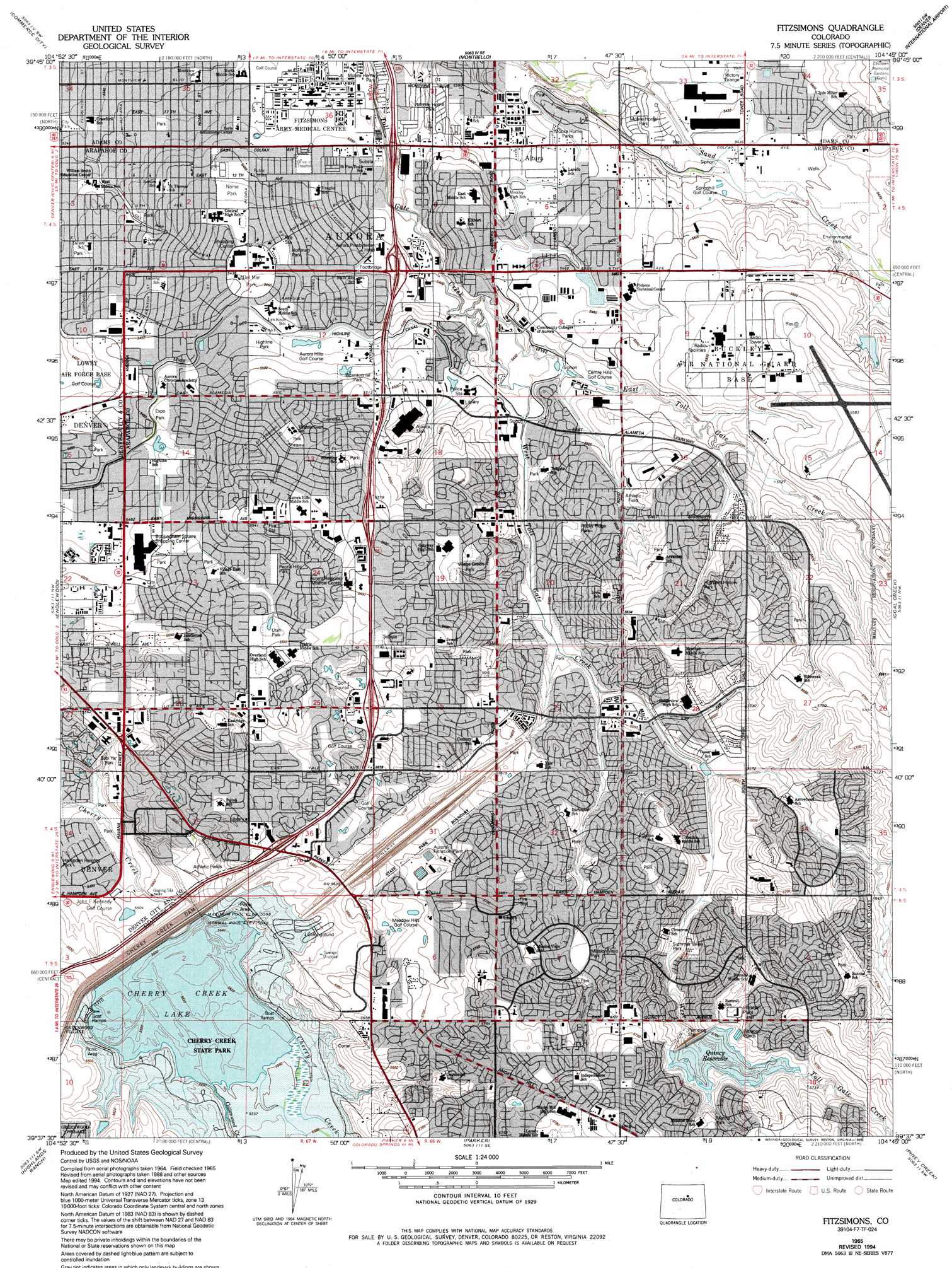
Fitzsimons Topo Map Colorado
To zoom in, hover over the map of Fitzsimons
USGS Topo Quad 39104f7 - 1:24,000 scale
| Topo Map Name: | Fitzsimons |
| USGS Topo Quad ID: | 39104f7 |
| Print Size: | ca. 21 1/4" wide x 27" high |
| Southeast Coordinates: | 39.625° N latitude / 104.75° W longitude |
| Map Center Coordinates: | 39.6875° N latitude / 104.8125° W longitude |
| U.S. State: | CO |
| Filename: | o39104f7.jpg |
| Download Map JPG Image: | Fitzsimons topo map 1:24,000 scale |
| Map Type: | Topographic |
| Topo Series: | 7.5´ |
| Map Scale: | 1:24,000 |
| Source of Map Images: | United States Geological Survey (USGS) |
| Alternate Map Versions: |
Fitzsimons CO 1948 Download PDF Buy paper map Fitzsimons CO 1957, updated 1958 Download PDF Buy paper map Fitzsimons CO 1957, updated 1962 Download PDF Buy paper map Fitzsimons CO 1965, updated 1966 Download PDF Buy paper map Fitzsimons CO 1965, updated 1966 Download PDF Buy paper map Fitzsimons CO 1965, updated 1973 Download PDF Buy paper map Fitzsimons CO 1965, updated 1973 Download PDF Buy paper map Fitzsimons CO 1965, updated 1980 Download PDF Buy paper map Fitzsimons CO 1965, updated 1985 Download PDF Buy paper map Fitzsimons CO 1965, updated 1994 Download PDF Buy paper map Fitzsimons CO 1965, updated 1994 Download PDF Buy paper map Fitzsimons CO 2010 Download PDF Buy paper map Fitzsimons CO 2013 Download PDF Buy paper map Fitzsimons CO 2016 Download PDF Buy paper map |
1:24,000 Topo Quads surrounding Fitzsimons
Lafayette |
Eastlake |
Brighton |
Mile High Lakes |
Horse Creek |
Arvada |
Commerce City |
Sable |
Box Elder School |
Manila |
Fort Logan |
Englewood |
Fitzsimons |
Coal Creek |
Watkins |
Littleton |
Highlands Ranch |
Parker |
Piney Creek |
Watkins Se |
Kassler |
Sedalia |
Castle Rock North |
Ponderosa Park |
Cabin Gulch |
> Back to 39104e1 at 1:100,000 scale
> Back to 39104a1 at 1:250,000 scale
> Back to U.S. Topo Maps home
Fitzsimons topo map: Gazetteer
Fitzsimons: Airports
Buckley Air National Guard Base elevation 1702m 5583′Cherry Creek Airport elevation 1714m 5623′
Humana Hospital Aurora Heliport elevation 1701m 5580′
Medical Center of Aurora North Campus Heliport elevation 1651m 5416′
Fitzsimons: Crossings
Exit 10 elevation 1639m 5377′Exit 4 elevation 1717m 5633′
Exit 5 elevation 1716m 5629′
Exit 7 elevation 1697m 5567′
Exit 8 elevation 1684m 5524′
Exit 9 elevation 1651m 5416′
Fitzsimons: Dams
Buckley Air National Guard Base Dam elevation 1691m 5547′Cherry Creek Dam elevation 1714m 5623′
Quincy Dam elevation 1733m 5685′
Fitzsimons: Mines
Cherry Creek Placers elevation 1724m 5656′H W Siddle Incorporated Pit elevation 1651m 5416′
Fitzsimons: Parks
Apache Mesa Park elevation 1661m 5449′Aurora Sports Park elevation 1662m 5452′
Babi Yar Park elevation 1682m 5518′
Ben Bezoff Park elevation 1662m 5452′
Bicentennial Park elevation 1677m 5501′
Canterbury Park elevation 1678m 5505′
Carson Park elevation 1732m 5682′
Centre Point Park elevation 1679m 5508′
Cherry Creek State Park elevation 1692m 5551′
City Center Park elevation 1665m 5462′
Del Mar Park elevation 1659m 5442′
Eagle Park elevation 1735m 5692′
Eastridge Park elevation 1714m 5623′
Eldorado Park elevation 1726m 5662′
Environmental Park elevation 1663m 5456′
Expo Park elevation 1666m 5465′
Flanders Park elevation 1713m 5620′
Freedom Park elevation 1643m 5390′
Freedom Park elevation 1643m 5390′
Fulton Park elevation 1642m 5387′
Generals Park elevation 1642m 5387′
Grandview Park elevation 1742m 5715′
Great Plains Park elevation 1730m 5675′
Hampden Run Park elevation 1710m 5610′
Havana And Cornell Park elevation 1670m 5479′
Havana Heights Park elevation 1702m 5583′
Havana Park elevation 1641m 5383′
Highland Hollow Park elevation 1700m 5577′
Highline Park elevation 1670m 5479′
Hill Top Park elevation 1734m 5688′
Hoffman Park elevation 1657m 5436′
Horizon Park elevation 1729m 5672′
Horseshoe Park elevation 1681m 5515′
J F Kennedy Park elevation 1692m 5551′
Kalispell Park elevation 1761m 5777′
La Parquita Park elevation 1736m 5695′
Marina Park elevation 1756m 5761′
McMullen Park elevation 1656m 5433′
Meadowood Park elevation 1714m 5623′
Mission Viejo Park elevation 1730m 5675′
Mountain View Park elevation 1690m 5544′
Nome Park elevation 1651m 5416′
Norfolk Glen Park elevation 1659m 5442′
Olympic Park elevation 1698m 5570′
Pagosa Park elevation 1717m 5633′
Panorama Park elevation 1704m 5590′
Peoria Hills Park elevation 1688m 5538′
Pheasant Run Park elevation 1759m 5770′
Rocky Ridge Park elevation 1681m 5515′
Sagebrush Park elevation 1738m 5702′
Seven Hills Park elevation 1714m 5623′
Side Creek Park elevation 1716m 5629′
Spencer Garrett Park elevation 1635m 5364′
Summer Valley Park elevation 1725m 5659′
Sunburst Park elevation 1745m 5725′
Sunrise Park elevation 1753m 5751′
Tierra Park elevation 1701m 5580′
Tollgate Park elevation 1667m 5469′
Triangle Park elevation 1667m 5469′
Utah Park elevation 1689m 5541′
Village East Park elevation 1682m 5518′
Village Green Park elevation 1697m 5567′
Virginia Court Park elevation 1692m 5551′
Wagon Trail Park elevation 1759m 5770′
Wheeling Park elevation 1705m 5593′
Fitzsimons: Populated Places
Altura elevation 1655m 5429′Apache Mesa elevation 1666m 5465′
Aurora elevation 1648m 5406′
Aurora Heights elevation 1649m 5410′
Aurora Highlands elevation 1701m 5580′
Aurora Hills elevation 1682m 5518′
Aurora Knolls elevation 1727m 5666′
Boston Heights elevation 1638m 5374′
Brookvale elevation 1677m 5501′
Centrepoint elevation 1681m 5515′
Chadsford elevation 1715m 5626′
Chambers Heights elevation 1658m 5439′
Colfax Village elevation 1644m 5393′
Del Mar elevation 1649m 5410′
Eastridge elevation 1717m 5633′
Fountain Side elevation 1683m 5521′
Friendly Village elevation 1651m 5416′
Gateway Park elevation 1635m 5364′
Hallcrafts Village East elevation 1693m 5554′
Harbor Pointe elevation 1735m 5692′
Havana Village elevation 1672m 5485′
Heather Ridge elevation 1702m 5583′
Highland Park elevation 1656m 5433′
Highpoint elevation 1750m 5741′
Hillcrest elevation 1648m 5406′
Hillcrest Village elevation 1635m 5364′
Hillside elevation 1639m 5377′
Hoffman Heights (subdivision) elevation 1652m 5419′
Hutchinson Heights elevation 1721m 5646′
Kingsborough elevation 1706m 5597′
Kirkgaard Acres elevation 1670m 5479′
La Vista elevation 1661m 5449′
Meadow Hills elevation 1742m 5715′
Meadowood elevation 1732m 5682′
Mission Viejo elevation 1729m 5672′
Nantucket elevation 1664m 5459′
Norfolk Glen elevation 1663m 5456′
Old Towne elevation 1675m 5495′
Park East elevation 1660m 5446′
Park View Estates elevation 1661m 5449′
Peoria Park elevation 1700m 5577′
Pheasant Run elevation 1758m 5767′
Queensborough elevation 1680m 5511′
Sableridge elevation 1708m 5603′
Settlers Village elevation 1689m 5541′
Seven Hills elevation 1716m 5629′
Shenandoah elevation 1763m 5784′
Side Creek elevation 1708m 5603′
Somerset Village elevation 1693m 5554′
Stone Ridge Park elevation 1692m 5551′
Summer Lake elevation 1755m 5757′
Summer Valley elevation 1727m 5666′
Sundown elevation 1727m 5666′
Sunnyvale elevation 1646m 5400′
Tollgate elevation 1685m 5528′
Village East elevation 1696m 5564′
Village Green elevation 1696m 5564′
Willow Park elevation 1693m 5554′
Woodgate elevation 1743m 5718′
Woodrim elevation 1708m 5603′
Fitzsimons: Post Offices
Altura Station Aurora Post Office elevation 1655m 5429′Aurora Post Office elevation 1678m 5505′
Fitzsimons Station Aurora Post Office elevation 1640m 5380′
Fletcher Station Aurora Post Office elevation 1629m 5344′
Gateway Station Aurora Post Office elevation 1724m 5656′
Hoffman Heights Station Aurora Post Office elevation 1657m 5436′
Fitzsimons: Reservoirs
Cherry Creek Lake elevation 1714m 5623′Quincy Reservoir elevation 1733m 5685′
Fitzsimons: Streams
Cottonwood Creek elevation 1692m 5551′East Toll Gate Creek elevation 1665m 5462′
West Toll Gate Creek elevation 1647m 5403′
Fitzsimons digital topo map on disk
Buy this Fitzsimons topo map showing relief, roads, GPS coordinates and other geographical features, as a high-resolution digital map file on DVD: