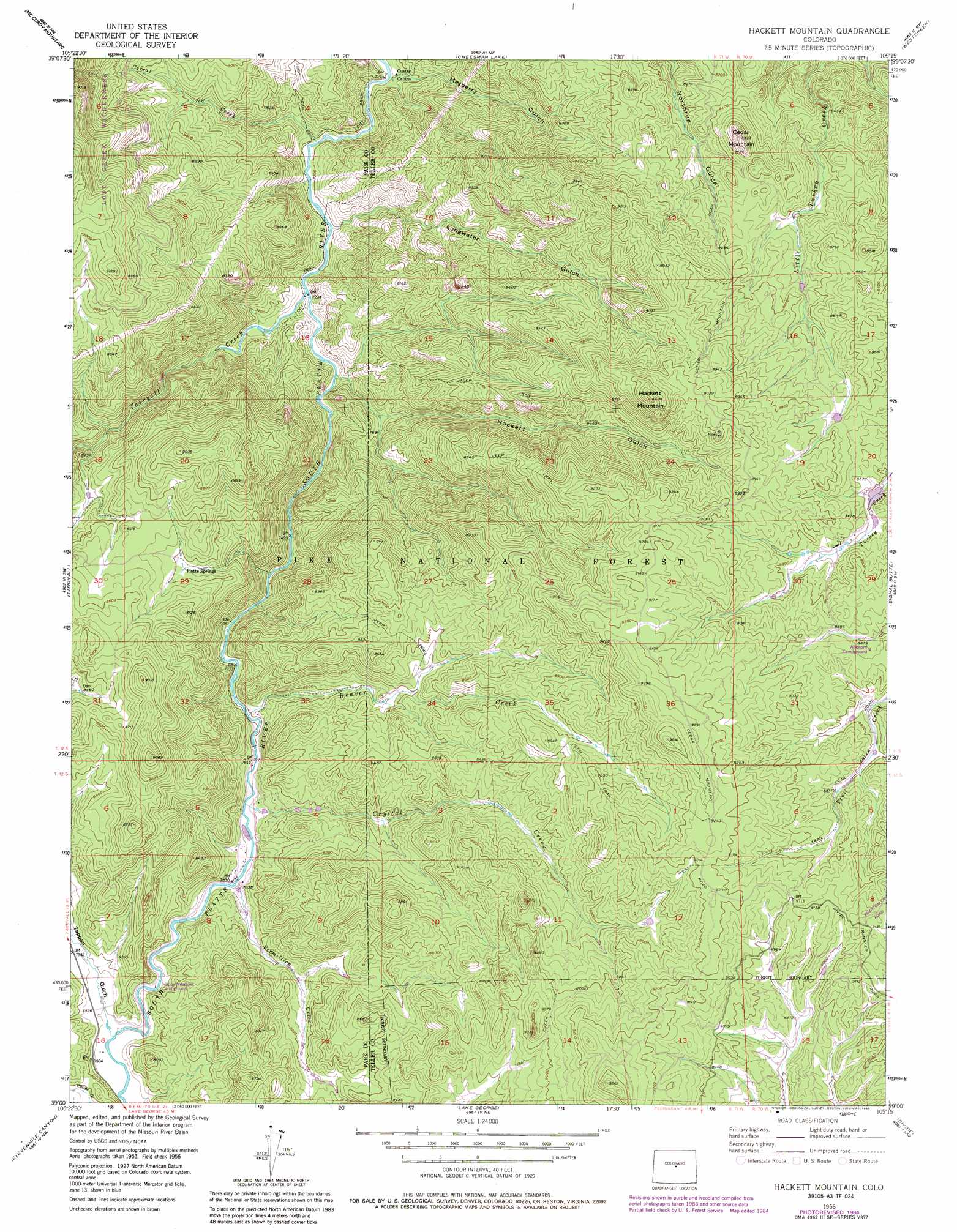
Hackett Mountain Topo Map Colorado
To zoom in, hover over the map of Hackett Mountain
USGS Topo Quad 39105a3 - 1:24,000 scale
| Topo Map Name: | Hackett Mountain |
| USGS Topo Quad ID: | 39105a3 |
| Print Size: | ca. 21 1/4" wide x 27" high |
| Southeast Coordinates: | 39° N latitude / 105.25° W longitude |
| Map Center Coordinates: | 39.0625° N latitude / 105.3125° W longitude |
| U.S. State: | CO |
| Filename: | o39105a3.jpg |
| Download Map JPG Image: | Hackett Mountain topo map 1:24,000 scale |
| Map Type: | Topographic |
| Topo Series: | 7.5´ |
| Map Scale: | 1:24,000 |
| Source of Map Images: | United States Geological Survey (USGS) |
| Alternate Map Versions: |
Hackett Mountain CO 1956, updated 1957 Download PDF Buy paper map Hackett Mountain CO 1956, updated 1960 Download PDF Buy paper map Hackett Mountain CO 1956, updated 1960 Download PDF Buy paper map Hackett Mountain CO 1956, updated 1971 Download PDF Buy paper map Hackett Mountain CO 1956, updated 1971 Download PDF Buy paper map Hackett Mountain CO 1956, updated 1977 Download PDF Buy paper map Hackett Mountain CO 1956, updated 1977 Download PDF Buy paper map Hackett Mountain CO 1956, updated 1980 Download PDF Buy paper map Hackett Mountain CO 1956, updated 1985 Download PDF Buy paper map Hackett Mountain CO 1994, updated 1998 Download PDF Buy paper map Hackett Mountain CO 1994, updated 1998 Download PDF Buy paper map Hackett Mountain CO 2011 Download PDF Buy paper map Hackett Mountain CO 2013 Download PDF Buy paper map Hackett Mountain CO 2016 Download PDF Buy paper map |
| FStopo: | US Forest Service topo Hackett Mountain is available: Download FStopo PDF Download FStopo TIF |
1:24,000 Topo Quads surrounding Hackett Mountain
Topaz Mountain |
Windy Peak |
Green Mountain |
Deckers |
Devils Head |
Farnum Peak |
Mccurdy Mountain |
Cheesman Lake |
Westcreek |
Dakan Mountain |
Glentivar |
Tarryall |
Hackett Mountain |
Signal Butte |
Mount Deception |
Spinney Mountain |
Elevenmile Canyon |
Lake George |
Divide |
Woodland Park |
Thirtynine Mile Mountain |
Witcher Mountain |
Wrights Reservoir |
Cripple Creek North |
Pikes Peak |
> Back to 39105a1 at 1:100,000 scale
> Back to 39104a1 at 1:250,000 scale
> Back to U.S. Topo Maps home
Hackett Mountain topo map: Gazetteer
Hackett Mountain: Dams
Hoder Recreation Dam elevation 2621m 8599′Hackett Mountain: Mines
Air Line Mine elevation 2750m 9022′Hilda May Number One Claim Mine elevation 2628m 8622′
Lake George Mine elevation 2410m 7906′
Tappan Mountain Prospect Pit elevation 2498m 8195′
Two Bit Claims Mine elevation 2447m 8028′
Hackett Mountain: Populated Places
Platte Springs elevation 2553m 8375′Hackett Mountain: Reservoirs
Hoder Recreation Reservoir elevation 2621m 8599′Hackett Mountain: Streams
Beaver Creek elevation 2384m 7821′Corral Creek elevation 2184m 7165′
Crystal Creek elevation 2383m 7818′
Tarryall Creek elevation 2202m 7224′
Vermillion Creek elevation 2388m 7834′
Hackett Mountain: Summits
Cedar Mountain elevation 2517m 8257′Hackett Mountain elevation 2873m 9425′
Hackett Mountain: Trails
Longwater Trail elevation 2601m 8533′Hackett Mountain: Valleys
Hackett Gulch elevation 2226m 7303′Longwater Gulch elevation 2195m 7201′
Metberry Gulch elevation 2178m 7145′
Tappan Gulch elevation 2412m 7913′
Hackett Mountain digital topo map on disk
Buy this Hackett Mountain topo map showing relief, roads, GPS coordinates and other geographical features, as a high-resolution digital map file on DVD: