Sulphur Mountain Topo Map Colorado
To zoom in, hover over the map of Sulphur Mountain
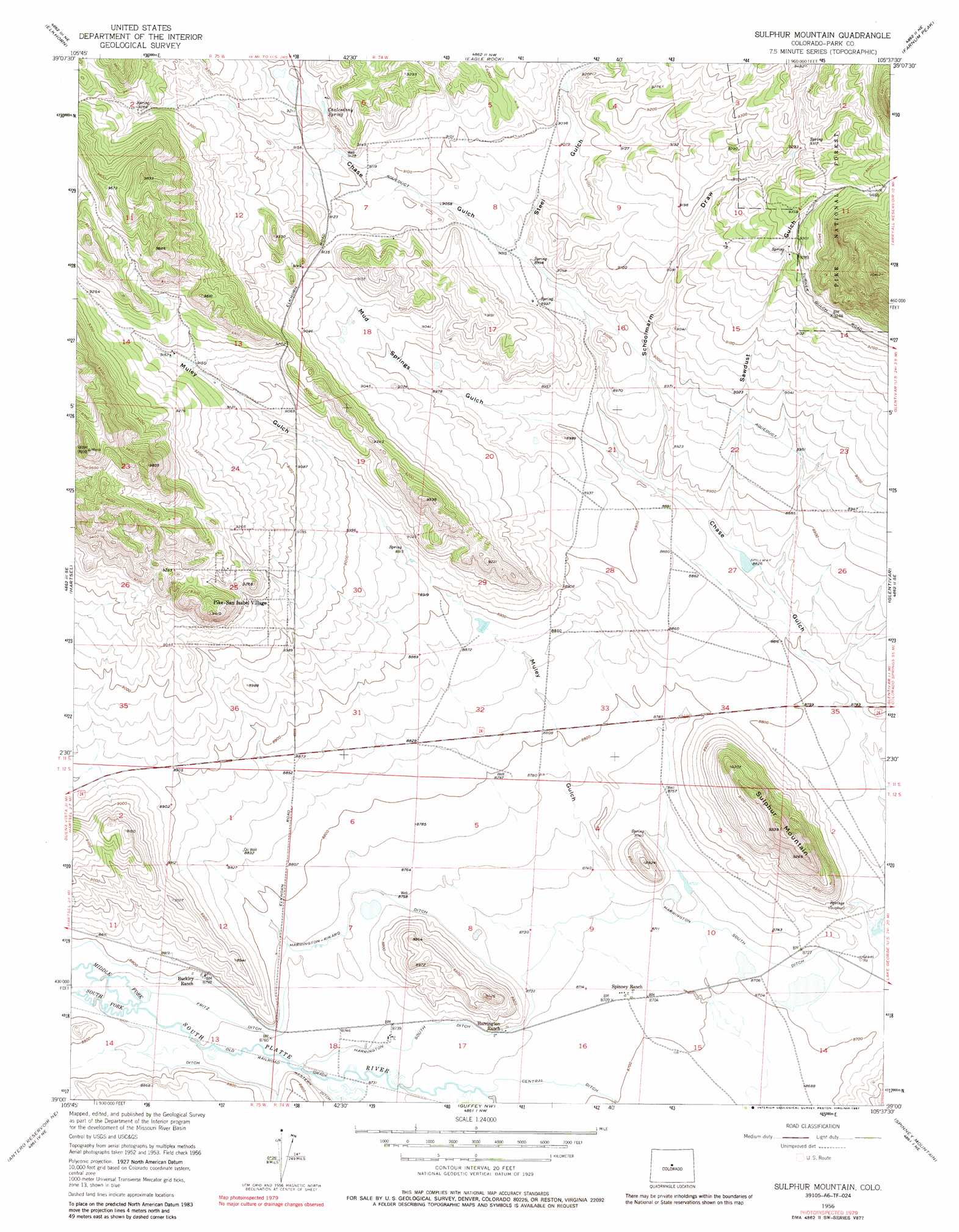
USGS Topo Quad 39105a6 - 1:24,000 scale
| Topo Map Name: | Sulphur Mountain |
| USGS Topo Quad ID: | 39105a6 |
| Print Size: | ca. 21 1/4" wide x 27" high |
| Southeast Coordinates: | 39° N latitude / 105.625° W longitude |
| Map Center Coordinates: | 39.0625° N latitude / 105.6875° W longitude |
| U.S. State: | CO |
| Filename: | o39105a6.jpg |
| Download Map JPG Image: | Sulphur Mountain topo map 1:24,000 scale |
| Map Type: | Topographic |
| Topo Series: | 7.5´ |
| Map Scale: | 1:24,000 |
| Source of Map Images: | United States Geological Survey (USGS) |
| Alternate Map Versions: |
Sulphur Mountain CO 1956, updated 1957 Download PDF Buy paper map Sulphur Mountain CO 1956, updated 1970 Download PDF Buy paper map Sulphur Mountain CO 1956, updated 1987 Download PDF Buy paper map Sulphur Mountain CO 1994, updated 1998 Download PDF Buy paper map Sulphur Mountain CO 2011 Download PDF Buy paper map Sulphur Mountain CO 2013 Download PDF Buy paper map Sulphur Mountain CO 2016 Download PDF Buy paper map |
| FStopo: | US Forest Service topo Sulphur Mountain is available: Download FStopo PDF Download FStopo TIF |
1:24,000 Topo Quads surrounding Sulphur Mountain
Como |
Milligan Lakes |
Observatory Rock |
Topaz Mountain |
Windy Peak |
Fairplay East |
Elkhorn |
Eagle Rock |
Farnum Peak |
Mccurdy Mountain |
Garo |
Hartsel |
Sulphur Mountain |
Glentivar |
Tarryall |
Antero Reservoir |
Antero Reservoir Ne |
Guffey Nw |
Spinney Mountain |
Elevenmile Canyon |
Castle Rock Gulch |
Agate Mountain |
Dicks Peak |
Thirtynine Mile Mountain |
Witcher Mountain |
> Back to 39105a1 at 1:100,000 scale
> Back to 39104a1 at 1:250,000 scale
> Back to U.S. Topo Maps home
Sulphur Mountain topo map: Gazetteer
Sulphur Mountain: Canals
Central Ditch elevation 2653m 8704′Fritz Ditch elevation 2672m 8766′
Harrington South Ditch elevation 2659m 8723′
Harrington-Rikard Ditch elevation 2678m 8786′
Sulphur Mountain: Populated Places
Pike-San Isabel Village elevation 2738m 8982′Sulphur Mountain: Springs
Chalcedony Spring elevation 2797m 9176′Sulphur Mountain: Streams
Middle Fork South Platte River elevation 2675m 8776′South Fork South Platte River elevation 2675m 8776′
Sulphur Mountain: Summits
Sulphur Mountain elevation 2844m 9330′Sulphur Mountain: Valleys
Mud Springs Gulch elevation 2708m 8884′Muley Gulch elevation 2659m 8723′
Rishaberger Gulch elevation 2670m 8759′
Sawdust Gulch elevation 2696m 8845′
Schoolmarm Draw elevation 2702m 8864′
Steel Gulch elevation 2748m 9015′
Sulphur Mountain digital topo map on disk
Buy this Sulphur Mountain topo map showing relief, roads, GPS coordinates and other geographical features, as a high-resolution digital map file on DVD: