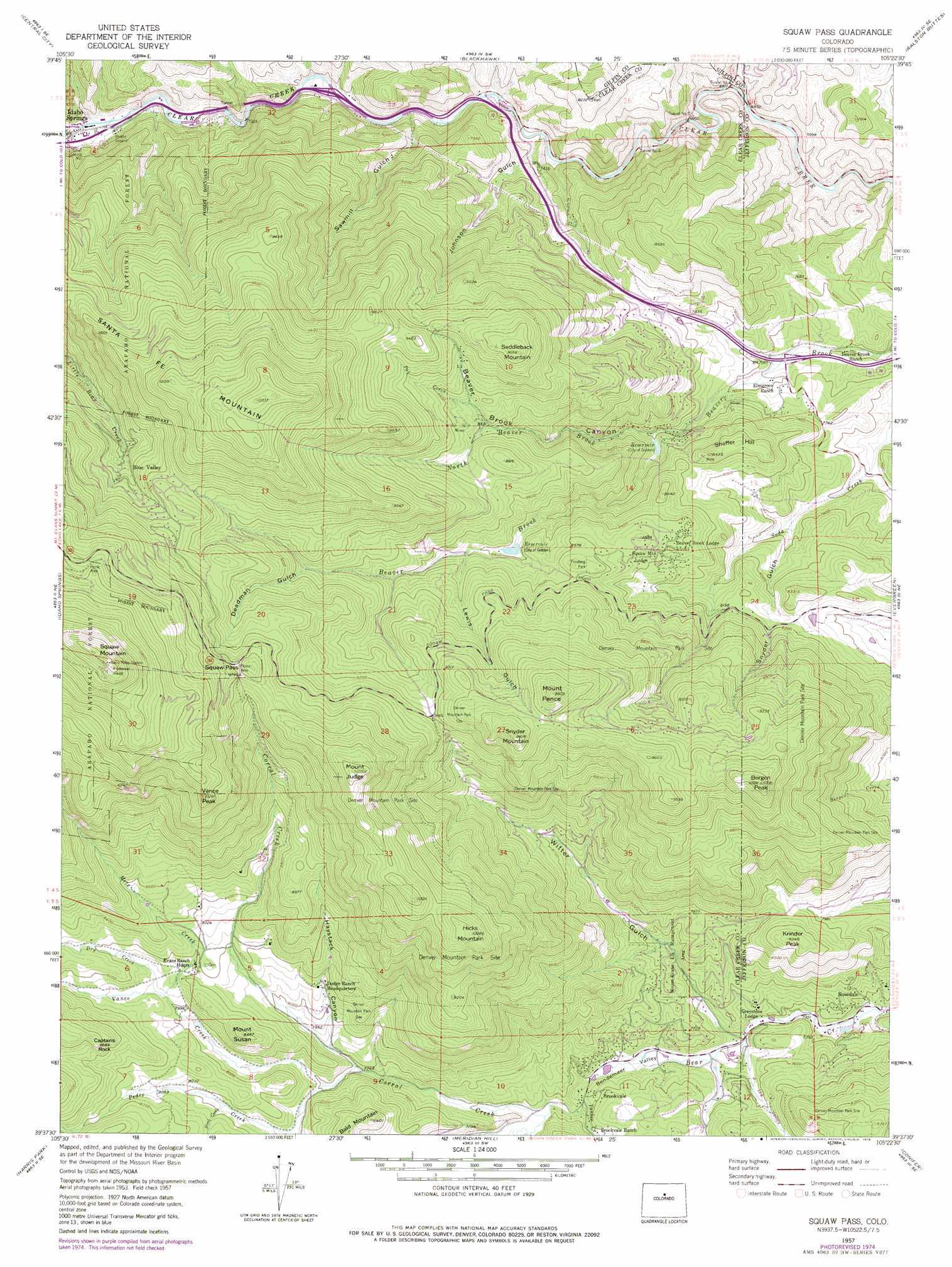
Squaw Pass Topo Map Colorado
To zoom in, hover over the map of Squaw Pass
USGS Topo Quad 39105f4 - 1:24,000 scale
| Topo Map Name: | Squaw Pass |
| USGS Topo Quad ID: | 39105f4 |
| Print Size: | ca. 21 1/4" wide x 27" high |
| Southeast Coordinates: | 39.625° N latitude / 105.375° W longitude |
| Map Center Coordinates: | 39.6875° N latitude / 105.4375° W longitude |
| U.S. State: | CO |
| Filename: | o39105f4.jpg |
| Download Map JPG Image: | Squaw Pass topo map 1:24,000 scale |
| Map Type: | Topographic |
| Topo Series: | 7.5´ |
| Map Scale: | 1:24,000 |
| Source of Map Images: | United States Geological Survey (USGS) |
| Alternate Map Versions: |
Squaw Pass CO 1957, updated 1959 Download PDF Buy paper map Squaw Pass CO 1957, updated 1963 Download PDF Buy paper map Squaw Pass CO 1957, updated 1971 Download PDF Buy paper map Squaw Pass CO 1957, updated 1976 Download PDF Buy paper map Squaw Pass CO 2011 Download PDF Buy paper map Squaw Pass CO 2013 Download PDF Buy paper map Squaw Pass CO 2016 Download PDF Buy paper map |
| FStopo: | US Forest Service topo Squaw Pass is available: Download FStopo PDF Download FStopo TIF |
1:24,000 Topo Quads surrounding Squaw Pass
East Portal |
Nederland |
Tunsgten |
Eldorado Springs |
Louisville |
Empire |
Central City |
Black Hawk |
Ralston Buttes |
Golden |
Georgetown |
Idaho Springs |
Squaw Pass |
Evergreen |
Morrison |
Mount Evans |
Harris Park |
Meridian Hill |
Conifer |
Indian Hills |
Mount Logan |
Shawnee |
Bailey |
Pine |
Platte Canyon |
> Back to 39105e1 at 1:100,000 scale
> Back to 39104a1 at 1:250,000 scale
> Back to U.S. Topo Maps home
Squaw Pass topo map: Gazetteer
Squaw Pass: Airports
Greystone Heliport elevation 2308m 7572′Ptarmigan Heliport elevation 2489m 8166′
Squaw Pass: Dams
Barker Meadow Dam elevation 2399m 7870′Beaver Brook Number 2 Dam elevation 2422m 7946′
Beaver Brook Number 3A Dam elevation 2561m 8402′
Hiwan Number 4 Dam elevation 2459m 8067′
Squaw Pass: Gaps
Squaw Pass elevation 2990m 9809′Squaw Pass: Mines
Beaver Brook Mica Lode elevation 2408m 7900′Beaver Brook Mine elevation 2598m 8523′
Brandt Mine elevation 2327m 7634′
Edwards Quarry elevation 2635m 8645′
Grover Mine elevation 2662m 8733′
Jacobson Ranch Mine elevation 2356m 7729′
Lone Star Placer Mine elevation 2192m 7191′
Lucky Strike Mine elevation 2520m 8267′
Mount Judge Mine elevation 3068m 10065′
Nabob Mine elevation 2598m 8523′
Old Soda Creek School Pegmatite Mine elevation 2732m 8963′
Quickie Iron Mine elevation 2447m 8028′
Santa Fe Mountain Mine elevation 2812m 9225′
Shaffer Hill Mine elevation 2363m 7752′
Snyder Beryl Claim Mine elevation 2866m 9402′
Tall Timber Number One Mine elevation 2468m 8097′
Tall Timber Number Two Mine elevation 2605m 8546′
Texaco Mine elevation 2393m 7851′
Squaw Pass: Parks
Frosberg Park elevation 2651m 8697′Mount Evans Elk Management Area elevation 2352m 7716′
Squaw Pass: Pillars
Captains Rock elevation 2649m 8690′Squaw Pass: Populated Places
Blue Valley elevation 2826m 9271′Brookvale elevation 2318m 7604′
Rosedale elevation 2282m 7486′
Squaw Pass: Reservoirs
Barker Meadow Reservoir elevation 2399m 7870′Beaver Brook Number 2 Reservoir elevation 2422m 7946′
Beaver Brook Number 3A Reservoir elevation 2561m 8402′
Hiwan Number 4 Reservoir elevation 2459m 8067′
Squaw Pass: Springs
Koser Spring elevation 2345m 7693′Squaw Pass: Streams
Corral Creek elevation 2299m 7542′Dry Creek elevation 2449m 8034′
Horse Creek elevation 2118m 6948′
Metz Creek elevation 2447m 8028′
North Beaver Brook elevation 2381m 7811′
North Clear Creek elevation 2105m 6906′
Pat Creek elevation 2605m 8546′
Pedee Creek elevation 2360m 7742′
Steel Creek elevation 2425m 7956′
Vance Creek elevation 2299m 7542′
Yankee Creek elevation 2286m 7500′
Squaw Pass: Summits
Bald Mountain elevation 2562m 8405′Bergen Peak elevation 2957m 9701′
Hicks Mountain elevation 3073m 10082′
Krinder Peak elevation 2544m 8346′
Mount Judge elevation 3132m 10275′
Mount Pence elevation 3014m 9888′
Mount Susan elevation 2577m 8454′
Saddleback Mountain elevation 2906m 9534′
Santa Fe Mountain elevation 3209m 10528′
Shaffer Hill elevation 2564m 8412′
Snyder Mountain elevation 2996m 9829′
Squaw Mountain elevation 3484m 11430′
Vance Peak elevation 3126m 10255′
Squaw Pass: Valleys
Beaver Brook Canyon elevation 2338m 7670′Bendemeer Valley elevation 2262m 7421′
Deadman Gulch elevation 2707m 8881′
Haystack Canyon elevation 2390m 7841′
J Ira Valley elevation 2282m 7486′
Johnson Gulch elevation 2191m 7188′
Lewis Gulch elevation 2571m 8435′
Sawmill Gulch elevation 2213m 7260′
Snyder Gulch elevation 2350m 7709′
Witter Gulch elevation 2270m 7447′
Squaw Pass digital topo map on disk
Buy this Squaw Pass topo map showing relief, roads, GPS coordinates and other geographical features, as a high-resolution digital map file on DVD: